
קובץ:Am-map he.svg

גודל התצוגה המקדימה הזאת מסוג PNG של קובץ ה־SVG הזה: 585 × 600 פיקסלים. רזולוציות אחרות: 234 × 240 פיקסלים | 468 × 480 פיקסלים | 749 × 768 פיקסלים | 999 × 1,024 פיקסלים | 1,998 × 2,048 פיקסלים | 1,169 × 1,198 פיקסלים.
לקובץ המקורי (קובץ SVG, הגודל המקורי: 1,169 × 1,198 פיקסלים, גודל הקובץ: 314 ק"ב)
| זהו קובץ שמקורו במיזם ויקישיתוף. תיאורו בדף תיאור הקובץ המקורי (בעברית) מוצג למטה. |
תקציר
| תיאור |
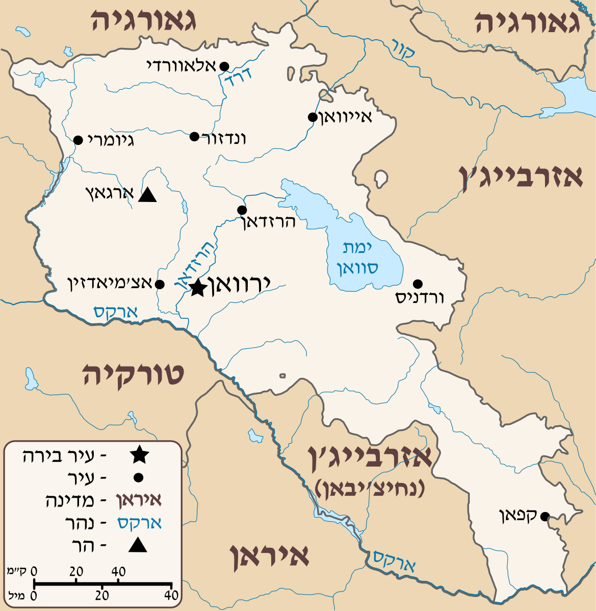
Deutsch: Positionskarte von Armenien. Quadratische Plattkarte, N-S-Streckung 130 %. Geographische Begrenzung der Karte: * N: 41.4° N * S: 38.8° N * W: 43.4° O * O: 46.7° O English: Location map of Armenia. Equirectangular projection, N/S stretching 130 %. Geographic limits of the map: * N: 41.4° N * S: 38.8° N * W: 43.4° E * E: 46.7° E Français : Carte administrative muette de l'Arménie. Projection cylindrique équidistante, avec étirement nord-sud de 130%. Limites de la carte : * N: 41,4° * O: 43,4° * S: 38,8° * E: 46,7° |
| תאריך יצירה | (UTC) |
| מקור |
קובץ זה הוא יצירה נגזרת של: Armenia location map.svg:  |
| יוצר |
|
| גרסאות אחרות |
[]
|


| זוהי תמונה מרוטשת, זאת אומרת שהתמונה שונתה בצורה דיגיטלית מהמקור. Modifications: HEBREW. את התמונה המקורית ניתן לראות ב: Armenia location map.svg.
|
רישיון
אני, בעל זכויות היוצרים על עבודה זו, מפרסם בזאת את העבודה תחת הרישיון הבא:
הקובץ הזה מתפרסם לפי תנאי רישיון קריאייטיב קומונז ייחוס-שיתוף זהה 3.0 לא מותאם.
- הנכם רשאים:
- לשתף – להעתיק, להפיץ ולהעביר את העבודה
- לערבב בין עבודות – להתאים את העבודה
- תחת התנאים הבאים:
- ייחוס – יש לתת ייחוס הולם, לתת קישור לרישיון, ולציין אם נעשו שינויים. אפשר לעשות את זה בכל צורה סבירה, אבל לא בשום צורה שמשתמע ממנה שמעניק הרישיון תומך בך או בשימוש שלך.
- שיתוף זהה – אם תיצרו רמיקס, תשנו, או תבנו על החומר, חובה עליכם להפיץ את התרומות שלך לפי תנאי רישיון זהה או תואם למקור.
יומן העלאה מקורי
This image is a derivative work of the following images:
- File:Armenia_location_map.svg licensed with Cc-by-sa-3.0
- 2012-04-05T19:55:11Z Sémhur 1169x1198 (213892 Bytes) ...with the former size
- 2012-04-05T19:47:53Z Sémhur 1000x1024 (213274 Bytes) Adding few rivers : Dzoraget, Aghstafa, Azat, Vedi and Megri
- 2011-01-15T11:52:05Z NordNordWest 1169x1198 (277162 Bytes) according to http://commons.wikimedia.org/w/index.php?title=User_talk%3AVarmin&action=historysubmit&diff=48288330&oldid=40674250
- 2011-01-14T17:54:35Z Varmin 1160x1190 (292375 Bytes) concordance avec les autres cartes vectorisée.
- 2010-08-28T16:58:09Z NordNordWest 1169x1198 (277162 Bytes) Barxudarlı, Yuxarı Əskipara and Karki stay officially non-Armenian (see [[:en:List of enclaves and exclaves]]), no changes without discussion
- 2010-08-28T16:34:29Z 6AND5 1160x1190 (292375 Bytes) (Exclaves deleted according to official map at http://www.gov.am/en/regions/)
- 2009-10-21T09:11:52Z NordNordWest 1169x1198 (277162 Bytes) '
- 2009-10-19T13:24:33Z NordNordWest 1169x1198 (275878 Bytes) '
- 2009-08-11T14:36:27Z NordNordWest 1169x1198 (275144 Bytes) {{int:filedesc}} {{Information |Description= {{de|Positionskarte von [[:de:Armenien|Armenien]]}} Quadratische Plattkarte, N-S-Streckung 130 %. Geographische Begrenzung der Karte: * N: 41.4° N * S: 38.8° N * W: 43.4° O * O:
Uploaded with derivativeFX
היסטוריית הקובץ
ניתן ללחוץ על תאריך/שעה כדי לראות את הקובץ כפי שנראה באותו זמן.
| תאריך/שעה | תמונה ממוזערת | ממדים | משתמש | הערה | |
|---|---|---|---|---|---|
| נוכחית | 16:44, 29 ביולי 2012 | | 1,198 × 1,169 (314 ק"ב) | Amirki | הוספת מקרא |
| 16:13, 29 ביולי 2012 |  | 1,198 × 1,169 (281 ק"ב) | Amirki | object to path | |
| 16:11, 29 ביולי 2012 |  | 1,198 × 1,169 (203 ק"ב) | Amirki | == {{int:filedesc}} == {{Information |Description={{Multilingual description |de= Positionskarte von Armenien.<br> Quadratische Plattkarte, N-S-Streckung 130 %. Geographische Begrenzung der Karte: * N: 41.4° N * S: 38.8° N * W: 43.4... |
שימוש בקובץ
הדף הבא משתמש בקובץ הזה: