
קובץ:Bass Strait infrastructure.png
אין גרסה ברזולוציה גבוהה יותר.
Bass_Strait_infrastructure.png (500 × 467 פיקסלים, גודל הקובץ: 191 ק"ב, סוג MIME: image/png)
| זהו קובץ שמקורו במיזם ויקישיתוף. תיאורו בדף תיאור הקובץ המקורי (בעברית) מוצג למטה. |
| תיאור |
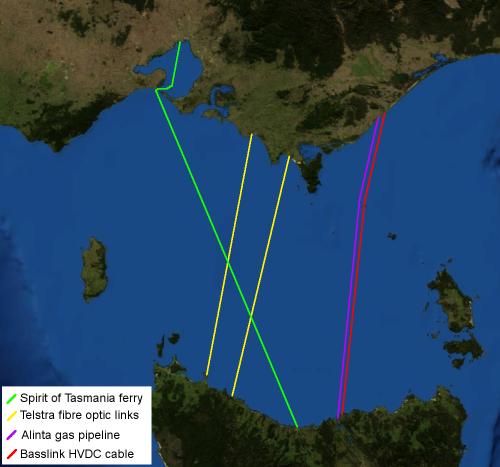
English: Map of Bass Strait including electrical, gas, communications and transport infrastructure.
Background imagery derived from NASA World Wind.
עברית: חיבורי תשתית עיקריים בין טסמניה ומדינת ויקטוריה |
| תאריך יצירה | 15 באפריל 2006 (תאריך העלאה מקורי) |
| מקור | הועבר מ- en.wikipedia לוויקישיתוףעל ידי Yuval Y באמצעות CommonsHelper. |
| יוצר | Chuq מוויקיפדיה האנגלית |
רישיון
| קובץ זה בנחלת הכלל כי הוא צילום מסך מתוכנת תוכנת הגלובוס של נאס"א, שעושה שימוש במרכיבים שנמצאים ברשות הציבור כמו: The Blue Marble, MODIS, Landsat, SRTM, USGS או GLOBE.
|
 |
| היצירה הזאת שוחררה לנחלת הכלל על־ידי היוצר שלה, Chuq מוויקיפדיה האנגלית. זה תקף בכל העולם. יש מדינות שבהן הדבר אינו אפשרי על פי חוק, אם כך: Chuq מעניק לכל אחד את הזכות להשתמש ביצירה הזאת לכל מטרה, ללא שום תנאי, אלא אם כן תנאים כאלה נדרשים לפי החוק. |
יומן העלאה מקורי
תיאור הקובץ המקורי נמצא כאן. כל שמות המשתמשים הבאים מתייחסים ל-en.wikipedia.
- 2006-04-15 06:46 Chuq 500×467× (195974 bytes) Map of [[Bass Strait]] including electrical, gas, communications and transport infrastructure. Background imagery derived from [[NASA World Wind]].
היסטוריית הקובץ
ניתן ללחוץ על תאריך/שעה כדי לראות את הקובץ כפי שנראה באותו זמן.
| תאריך/שעה | תמונה ממוזערת | ממדים | משתמש | הערה | |
|---|---|---|---|---|---|
| נוכחית | 15:49, 8 ביולי 2009 | | 467 × 500 (191 ק"ב) | File Upload Bot (Magnus Manske) | {{BotMoveToCommons|en.wikipedia|year={{subst:CURRENTYEAR}}|month={{subst:CURRENTMONTHNAME}}|day={{subst:CURRENTDAY}}}} {{Information |Description={{en|Map of en:Bass Strait including electrical, gas, communications and transport infrastructure. Ba |
שימוש בקובץ
הדף הבא משתמש בקובץ הזה:
שימוש גלובלי בקובץ
אתרי הוויקי השונים הבאים משתמשים בקובץ זה:
- שימוש באתר en.wikipedia.org
- שימוש באתר hy.wikipedia.org
- שימוש באתר ru.wikipedia.org