
קובץ:Battle of Hampton Roads Map.png
גודל התצוגה המקדימה הזאת: 603 × 600 פיקסלים. רזולוציות אחרות: 241 × 240 פיקסלים | 483 × 480 פיקסלים | 939 × 934 פיקסלים.
לקובץ המקורי (939 × 934 פיקסלים, גודל הקובץ: 397 ק"ב, סוג MIME: image/png)
| זהו קובץ שמקורו במיזם ויקישיתוף. תיאורו בדף תיאור הקובץ המקורי (בעברית) מוצג למטה. |
תקציר
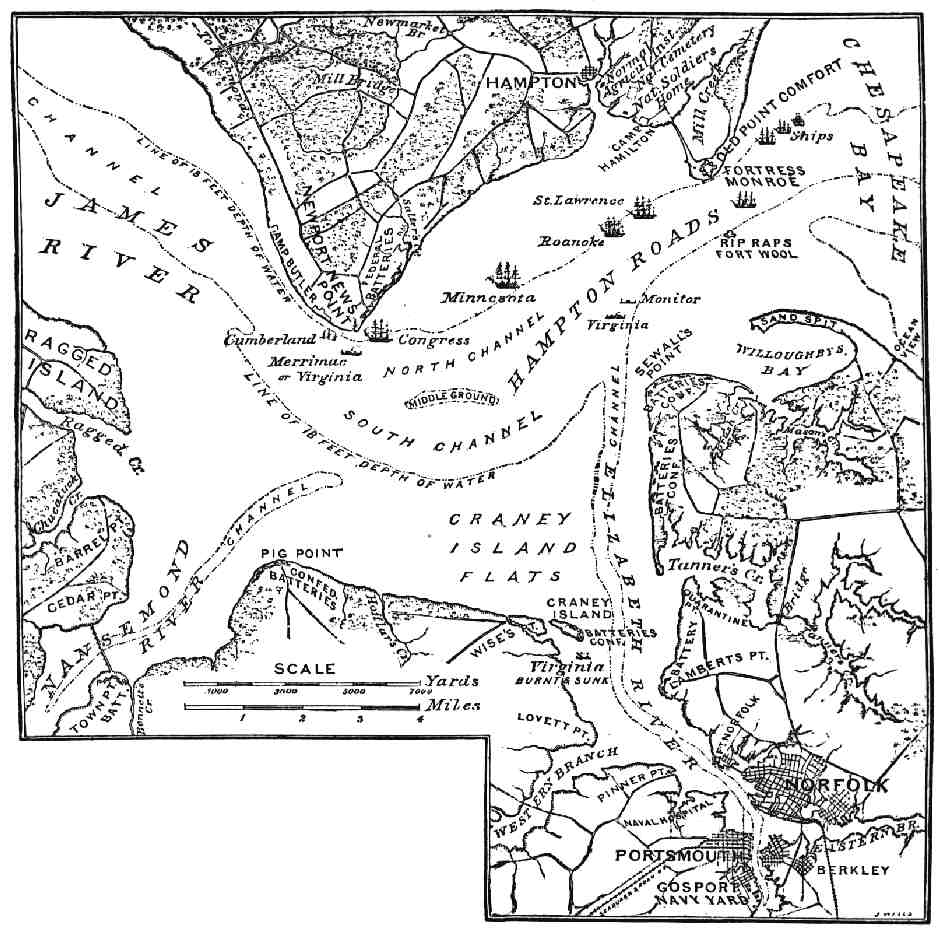
| תיאור | "Map of Hampton Roads and Vicinity." The First Fight of Iron-clads. |
| תאריך יצירה | |
| מקור | The Century Magazine, Vol. XXIX, March 1885. |
| יוצר | John Taylor Wood. |
| אישורים והיתרים (שימוש חוזר בקובץ זה) |
public domain |
Source.
A higher-resolution, more detailed, color map of the Battle of Hampton Roads is available at the Library of Congress website.
Taken via Wikipedia-En, originally uploaded by en:User:Brian0918
רישיון
This work is in the public domain in the United States because it was published (or registered with the U.S. Copyright Office) before January 1, 1929.
Public domain works must be out of copyright in both the United States and in the source country of the work in order to be hosted on the Commons. If the work is not a U.S. work, the file must have an additional copyright tag indicating the copyright status in the source country.
Note: This tag should not be used for sound recordings. |
היסטוריית הקובץ
ניתן ללחוץ על תאריך/שעה כדי לראות את הקובץ כפי שנראה באותו זמן.
| תאריך/שעה | תמונה ממוזערת | ממדים | משתמש | הערה | |
|---|---|---|---|---|---|
| נוכחית | 22:09, 3 באוקטובר 2005 | | 934 × 939 (397 ק"ב) | Pibwl |
שימוש בקובץ
הדף הבא משתמש בקובץ הזה:
שימוש גלובלי בקובץ
אתרי הוויקי השונים הבאים משתמשים בקובץ זה:
- שימוש באתר da.wikipedia.org
- שימוש באתר de.wikipedia.org
- שימוש באתר en.wikipedia.org
- שימוש באתר fr.wikipedia.org
- שימוש באתר it.wikipedia.org
- שימוש באתר ja.wikipedia.org
- שימוש באתר nl.wikipedia.org
- שימוש באתר pl.wikipedia.org
- שימוש באתר ru.wikipedia.org
- שימוש באתר sr.wikipedia.org
- שימוש באתר sv.wikipedia.org
- שימוש באתר uk.wikipedia.org