
קובץ:Breakwater break1 new(USGS).jpg

לקובץ המקורי (1,493 × 984 פיקסלים, גודל הקובץ: 812 ק"ב, סוג MIME: image/jpeg)
| זהו קובץ שמקורו במיזם ויקישיתוף. תיאורו בדף תיאור הקובץ המקורי (בעברית) מוצג למטה. |
.jpg)
.jpg?uselang=he)
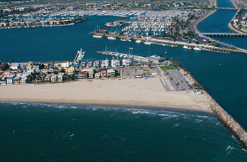
Breakwater.
Breakwaters create safe harbors but can also trap sediment moving along the coast. Long Beach Harbor, April, 1998
From: USGS
A more accurate description: The sand buildup shown is on the southeast end of the Long Beach Peninsula, with the jetty blocking the southward movement of sand being the west side of the entrance to Alamitos Bay. In the background, to the right of the center, is the Alamitos Bay Landing commercial area of the Long Beach Marina. To the far right in the back is the w:San Gabriel River. In the back top left is the sotheast end of w:Naples, a residential island in Alamitos Bay. The ocean shown in the foreground is the very southeast end of the Long Beach Outer Harbor.
This work is in the public domain in the United States because it is a work prepared by an officer or employee of the United States Government as part of that person’s official duties under the terms of Title 17, Chapter 1, Section 105 of the US Code.
Note: This only applies to original works of the Federal Government and not to the work of any individual U.S. state, territory, commonwealth, county, municipality, or any other subdivision. This template also does not apply to postage stamp designs published by the United States Postal Service since 1978. (See § 313.6(C)(1) of Compendium of U.S. Copyright Office Practices). It also does not apply to certain US coins; see The US Mint Terms of Use.
|
 | |
| הקובץ הזה זוהה כקובץ חופשי מכל מגבלה ידועה תחת חוק זכויות היוצרים, כולל כל הזכויות הקשורות והסמוכות. | ||
היסטוריית הקובץ
ניתן ללחוץ על תאריך/שעה כדי לראות את הקובץ כפי שנראה באותו זמן.
| תאריך/שעה | תמונה ממוזערת | ממדים | משתמש | הערה | |
|---|---|---|---|---|---|
| נוכחית | 12:31, 10 ביוני 2010 | | 984 × 1,493 (812 ק"ב) | Quibik | cropped away 3 px from right edge and cloned the bottom edge a bit to remove black background |
| 12:28, 10 ביוני 2010 |  | 984 × 1,496 (814 ק"ב) | Quibik | removed the timestamp | |
| 21:05, 11 בדצמבר 2009 |  | 984 × 1,496 (841 ק"ב) | Foobaz | Larger version from http://coastal.er.usgs.gov/cgi-bin/response.pl?site=sc&loc=25 . | |
| 12:02, 21 באפריל 2005 |  | 193 × 295 (9 ק"ב) | Feydey | Breakwater. Breakwaters create safe harbors but can also trap sediment moving along the coast. Long Beach Harbor, April, 1998 From: [http://walrus.wr.usgs.gov/cabrillo/playa/breakwater.html USGS] {{PD-USGov}} |
שימוש בקובץ
הדף הבא משתמש בקובץ הזה:
שימוש גלובלי בקובץ
אתרי הוויקי השונים הבאים משתמשים בקובץ זה:
- שימוש באתר az.wikipedia.org
- שימוש באתר da.wikipedia.org
- שימוש באתר el.wikipedia.org
- שימוש באתר en.wikipedia.org
- שימוש באתר fi.wikipedia.org
- שימוש באתר id.wikipedia.org
- שימוש באתר kn.wikipedia.org
- שימוש באתר ml.wikipedia.org
- שימוש באתר sco.wikipedia.org
- שימוש באתר simple.wikipedia.org
- שימוש באתר vi.wikipedia.org
.jpg)