
קובץ:Connecticut River Map.png
גודל התצוגה המקדימה הזאת: 448 × 600 פיקסלים. רזולוציות אחרות: 179 × 240 פיקסלים | 578 × 774 פיקסלים.
לקובץ המקורי (578 × 774 פיקסלים, גודל הקובץ: 58 ק"ב, סוג MIME: image/png)
| זהו קובץ שמקורו במיזם ויקישיתוף. תיאורו בדף תיאור הקובץ המקורי (בעברית) מוצג למטה. |
תקציר
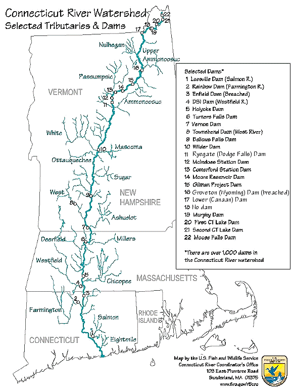
| תיאור | Map of the Connecticut River, New England, USA. This map was prepared by the United States Fish and Wildlife Service, and as a product of the United States Government is in the public domain and not subject to copyright restrictions. | |||
| מקור | Originally from en.wikipedia; description page is/was here. Original uploader was Daderot מוויקיפדיה האנגלית | |||
| יוצר | USGov | |||
| אישורים והיתרים (שימוש חוזר בקובץ זה) |
|


|
יש ליצור מחדש את התמונה transport map הזו באמצעות גרפיקה וקטורית כדוגמת קובץ SVG. לפעולה זו מספר יתרונות, כפי שניתן לקרוא (באנגלית) בדף Commons:Media for cleanup. אם ברשותכם קובץ SVG, אנא העלו אותו. לאחר מכן, החליפו תבנית זו בתבנית
{{vector version available|שם הקובץ.svg}} |
יומן העלאה מקורי
| תאריך/שעה | ממדים | משתמש | הערה |
|---|---|---|---|
| 6 בינואר 2008, 16:02:00 | 580 × 778 (61343 bytes) | Gridge (שיחה · תרומות) | {{Information |Description=Map of the Connecticut River, New England, USA. This map was prepared by the United States Fish and Wildlife Service, and as a product of the United States Government is in the public domain and not subject to copyright restrict |
היסטוריית הקובץ
ניתן ללחוץ על תאריך/שעה כדי לראות את הקובץ כפי שנראה באותו זמן.
| תאריך/שעה | תמונה ממוזערת | ממדים | משתמש | הערה | |
|---|---|---|---|---|---|
| נוכחית | 11:26, 10 במרץ 2024 | | 774 × 578 (58 ק"ב) | Lojwe | Cropped < 1 % horizontally, 1 % vertically using CropTool with precise mode. |
| 07:45, 25 בנובמבר 2014 |  | 778 × 580 (74 ק"ב) | GifTagger | Bot: Converting file to superior PNG file. (Source: Connecticut_River_Map.gif). This GIF was problematic due to non-greyscale color table. |
שימוש בקובץ
הדף הבא משתמש בקובץ הזה:
שימוש גלובלי בקובץ
אתרי הוויקי השונים הבאים משתמשים בקובץ זה:
- שימוש באתר bg.wikipedia.org
- שימוש באתר cs.wikipedia.org
- שימוש באתר da.wikipedia.org
- שימוש באתר de.wikipedia.org
- שימוש באתר en.wikipedia.org
- שימוש באתר es.wikipedia.org
- שימוש באתר fi.wikipedia.org
- שימוש באתר fr.wikipedia.org
- שימוש באתר fy.wikipedia.org
- שימוש באתר incubator.wikimedia.org
- שימוש באתר it.wikipedia.org
- שימוש באתר ja.wikipedia.org
- שימוש באתר nl.wikipedia.org
- שימוש באתר pt.wikipedia.org
- שימוש באתר ru.wikipedia.org
- שימוש באתר simple.wikipedia.org
- שימוש באתר sv.wikipedia.org
- שימוש באתר sw.wikipedia.org
- שימוש באתר ta.wikipedia.org
- שימוש באתר th.wikipedia.org
- שימוש באתר www.wikidata.org
- שימוש באתר zh.wikipedia.org