
קובץ:Gelre1477.png
גודל התצוגה המקדימה הזאת: 688 × 600 פיקסלים. רזולוציות אחרות: 275 × 240 פיקסלים | 551 × 480 פיקסלים | 772 × 673 פיקסלים.
לקובץ המקורי (772 × 673 פיקסלים, גודל הקובץ: 937 ק"ב, סוג MIME: image/png)
| זהו קובץ שמקורו במיזם ויקישיתוף. תיאורו בדף תיאור הקובץ המקורי (בעברית) מוצג למטה. |
תקציר
| תיאור |
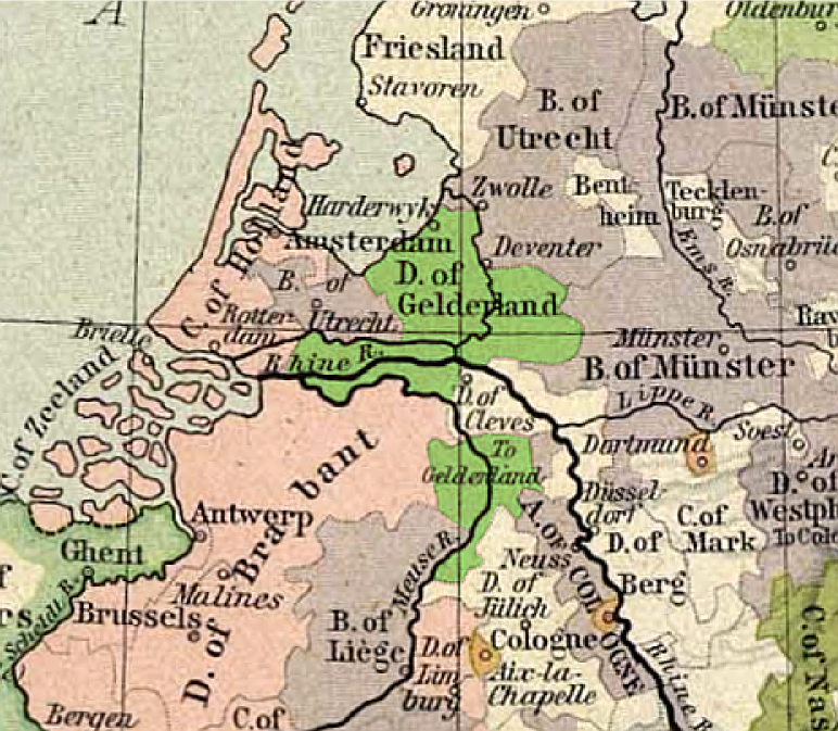
Français : Carte du duché de Gueldre, en 1477
English: Map of duchy of Guelders, in 1477 |
| תאריך יצירה | |
| מקור | from Historical Atlas by William R. Shepherd, 1926. |
| יוצר | original map: de:Velhagen & Klasing |
רישיון
היוצר נפטר בשנת 1934, לכן יצירה זו נמצאת בנחלת הכלל במדינת המקור ובמדינות אחרות בהם תקופת זכויות היוצרים היא משך חיי היוצר ו-80 שנה (או פחות) מפטירתו.
| |
| הקובץ הזה זוהה כקובץ חופשי מכל מגבלה ידועה תחת חוק זכויות היוצרים, כולל כל הזכויות הקשורות והסמוכות. | |
This work is in the public domain because it was published in the United States between 1929 and 1963, and although there may or may not have been a copyright notice, the copyright was not renewed. For further explanation, see Commons:Hirtle chart and the copyright renewal logs. Note that it may still be copyrighted in jurisdictions that do not apply the rule of the shorter term for US works (depending on the date of the author's death), such as Canada (70 years p.m.a.), Mainland China (50 years p.m.a., not Hong Kong or Macao), Germany (70 years p.m.a.), Mexico (100 years p.m.a.), Switzerland (70 years p.m.a.), and other countries with individual treaties.
|
 |
יומן העלאה מקורי
- uploadé sur Wikipédia NL par User:Känsterle le 17 décembre 2005.
- Highlighting of Guelders: User:Eugene van der Pijll.
היסטוריית הקובץ
ניתן ללחוץ על תאריך/שעה כדי לראות את הקובץ כפי שנראה באותו זמן.
| תאריך/שעה | תמונה ממוזערת | ממדים | משתמש | הערה | |
|---|---|---|---|---|---|
| נוכחית | 23:13, 13 במאי 2011 | | 673 × 772 (937 ק"ב) | Hans Erren | corrected southern boundary to include ambt montfort. Reloaded original perry castaneda map, Rotated to true north, adjusted gamma, sharpened, fill coloured area in more pastel tone. |
| 22:02, 25 בפברואר 2006 |  | 277 × 334 (183 ק"ב) | Eugene van der Pijll | ||
| 21:20, 25 בפברואר 2006 |  | 277 × 334 (165 ק"ב) | Odejea | == Description == Carte du duché de Gueldre, en 1477 Origine : * collection de cartes de l'Université du Texas (http://www.lib.utexas.edu/maps/). Ces cartes sont dans le domaine public (http://www.lib.utexas.edu/maps/faq.html#3.html). * uploadé sur W |
שימוש בקובץ
הדף הבא משתמש בקובץ הזה:
שימוש גלובלי בקובץ
אתרי הוויקי השונים הבאים משתמשים בקובץ זה:
- שימוש באתר af.wikipedia.org
- שימוש באתר ar.wikipedia.org
- שימוש באתר br.wikipedia.org
- שימוש באתר ca.wikipedia.org
- שימוש באתר da.wikipedia.org
- שימוש באתר de.wikipedia.org
- שימוש באתר en.wikipedia.org
- שימוש באתר et.wikipedia.org
- שימוש באתר fr.wikipedia.org
- שימוש באתר hu.wikibooks.org
- שימוש באתר it.wikipedia.org
- שימוש באתר li.wikipedia.org
- שימוש באתר nds-nl.wikipedia.org
- שימוש באתר nl.wikipedia.org
- שימוש באתר nn.wikipedia.org
- שימוש באתר no.wikipedia.org
- שימוש באתר pl.wikipedia.org
- שימוש באתר pt.wikipedia.org
- שימוש באתר ru.wikipedia.org
- שימוש באתר th.wikipedia.org