
קובץ:Geological mapping1.gif
אין גרסה ברזולוציה גבוהה יותר.
Geological_mapping1.gif (223 × 158 פיקסלים, גודל הקובץ: 9 ק"ב, סוג MIME: image/gif)
| זהו קובץ שמקורו במיזם ויקישיתוף. תיאורו בדף תיאור הקובץ המקורי (בעברית) מוצג למטה. |
תקציר
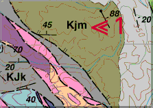
| תיאור | Each geologic unit on a geological map is assigned a set of letters to symbolize it on the map (for example, to the left of the red arrows at location 1). Usually the symbol is the combination of an initial capital letter followed by one or more small letters. The capital letter represents the age of the geologic unit. |
| תאריך יצירה | לפני 2000-09-26 |
| מקור | http://www.nature.nps.gov/geology/usgsnps/gmap/gmap2.html |
| יוצר | National Park Service and Russell W. Graymer of Western Region Mapping Team, U.S. Geological Survey |
רישיון
This image is in the public domain in the United States because it only contains materials that originally came from the United States Geological Survey, an agency of the United States Department of the Interior. For more information, see the official USGS copyright policy.
|
היסטוריית הקובץ
ניתן ללחוץ על תאריך/שעה כדי לראות את הקובץ כפי שנראה באותו זמן.
| תאריך/שעה | תמונה ממוזערת | ממדים | משתמש | הערה | |
|---|---|---|---|---|---|
| נוכחית | 16:17, 26 בינואר 2011 | | 158 × 223 (9 ק"ב) | דקי |
שימוש בקובץ
הדפים הבאים משתמשים בקובץ הזה: