
קובץ:Habsburg Map 1547.jpg
לקובץ המקורי (1,654 × 1,029 פיקסלים, גודל הקובץ: 534 ק"ב, סוג MIME: image/jpeg)
| זהו קובץ שמקורו במיזם ויקישיתוף. תיאורו בדף תיאור הקובץ המקורי (בעברית) מוצג למטה. |
תקציר
| תיאור |
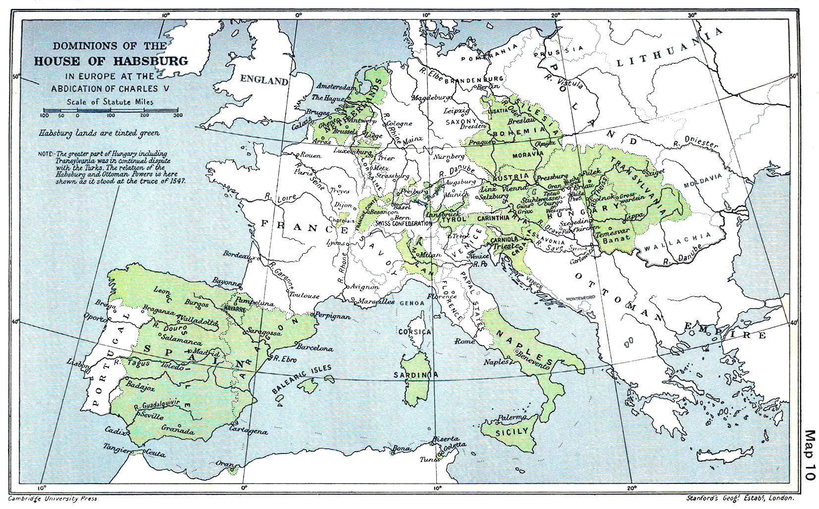
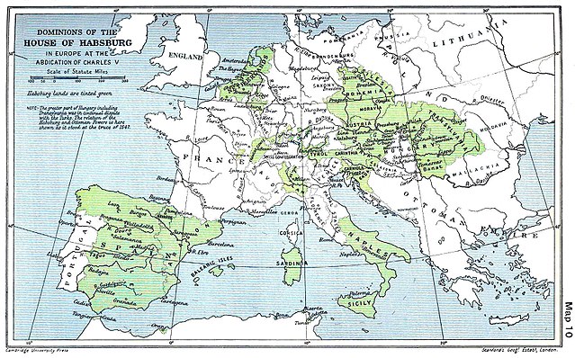
English: A map of the dominion of the Habsburgs following the Battle of Mühlberg (1547) |
| תאריך יצירה | |
| מקור |
The Cambridge Modern History Atlas, edited by Sir Adolphus William Ward, G.W. Prothero, Sir Stanley Mordaunt Leathes, and E.A. Benians. Cambridge University Press: London, 1912. Editors were Sir Adolphus William Ward (†1924), G.W. Prothero (†1922), and Sir Stanley Mordaunt Leathes (†1938). Individual authors of works making up the atlas are not identified, nor are the likely to be, after reasonable research. |
| יוצר | edited by Sir Adolphus William Ward, G.W. Prothero, Sir Stanley Mordaunt Leathes |
| גרסאות אחרות |
|

רישיון
This work is in the public domain in the United States because it was published (or registered with the U.S. Copyright Office) before January 1, 1929.
Public domain works must be out of copyright in both the United States and in the source country of the work in order to be hosted on the Commons. If the work is not a U.S. work, the file must have an additional copyright tag indicating the copyright status in the source country.
Note: This tag should not be used for sound recordings. |
This UK artistic or literary work, of which the author is unknown and cannot be ascertained by reasonable enquiry, is in the public domain because it is one of the following:
|
 |
היסטוריית הקובץ
ניתן ללחוץ על תאריך/שעה כדי לראות את הקובץ כפי שנראה באותו זמן.
| תאריך/שעה | תמונה ממוזערת | ממדים | משתמש | הערה | |
|---|---|---|---|---|---|
| נוכחית | 12:20, 29 במרץ 2018 | | 1,029 × 1,654 (534 ק"ב) | Trecătorul răcit | Little add: borders of the time |
| 14:01, 3 בספטמבר 2015 |  | 1,029 × 1,654 (518 ק"ב) | Kurzon | Reverted to version as of 17:22, 9 August 2010 | |
| 14:01, 3 בספטמבר 2015 |  | 1,029 × 1,654 (518 ק"ב) | Kurzon | Reverted to version as of 17:22, 9 August 2010 | |
| 00:33, 30 ביוני 2013 |  | 1,029 × 1,654 (546 ק"ב) | CSvBibra | add more contrast per request by another user | |
| 20:22, 9 באוגוסט 2010 |  | 1,029 × 1,654 (518 ק"ב) | CSvBibra | Previously put cleaned up version in new file with "b" after name. Now updating original file with "b" version. Both files uses throughout Wikipedias | |
| 12:07, 28 באוגוסט 2008 |  | 1,029 × 1,654 (649 ק"ב) | F l a n k e r | Wrap, shadows and minor improvements | |
| 17:42, 28 ביוני 2005 |  | 1,029 × 1,654 (421 ק"ב) | Rythin~commonswiki | A map of the dominion of the Habsburgs following the Battle of Mühlberg (1547). Taken from ''The Cambridge Modern History Atlas,'' edited by Sir Adolphus William Ward, G.W. Prothero, Sir Stanley Mordaunt Leathes, and E.A. Benians. Cambridge University Pr |
שימוש בקובץ
הדפים הבאים משתמשים בקובץ הזה:
שימוש גלובלי בקובץ
אתרי הוויקי השונים הבאים משתמשים בקובץ זה:
- שימוש באתר af.wikipedia.org
- שימוש באתר an.wikipedia.org
- שימוש באתר ar.wikipedia.org
- שימוש באתר arz.wikipedia.org
- שימוש באתר ast.wikipedia.org
- שימוש באתר azb.wikipedia.org
- שימוש באתר ba.wikipedia.org
- שימוש באתר be.wikipedia.org
- שימוש באתר bg.wikipedia.org
- שימוש באתר br.wikipedia.org
- שימוש באתר bs.wikipedia.org
- שימוש באתר ca.wikipedia.org
- שימוש באתר cs.wikipedia.org
- שימוש באתר da.wikipedia.org
- שימוש באתר de.wikipedia.org
- שימוש באתר el.wikipedia.org