
קובץ:Karte Aut Ooe SE.png
אין גרסה ברזולוציה גבוהה יותר.
Karte_Aut_Ooe_SE.png (300 × 265 פיקסלים, גודל הקובץ: 4 ק"ב, סוג MIME: image/png)
| זהו קובץ שמקורו במיזם ויקישיתוף. תיאורו בדף תיאור הקובץ המקורי (בעברית) מוצג למטה. |
תקציר
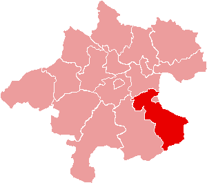
| תיאור | Location of Bezirk Steyr-Land within the Land of Upper Austria |
| תאריך יצירה | |
| מקור | de:Bild:Karte Aut Ooe SE.png |
| יוצר | de:Benutzer:Plp |
| אישורים והיתרים (שימוש חוזר בקובץ זה) |
GFDL-author (licence from German Wikipedia) |
| גרסאות אחרות | de:Bild:Karte Aut Ooe SE.png |
רישיון

|
מוענקת בכך הרשות להעתיק, להפיץ או לשנות את המסמך הזה, לפי תנאי הרישיון לשימוש חופשי במסמכים של גנו, גרסה 1.2 או כל גרסה מאוחרת יותר שתפורסם על־ידי המוסד לתוכנה חופשית; ללא פרקים קבועים, ללא טקסט עטיפה קדמית וללא טקסט עטיפה אחורית. עותק של הרישיון כלול בפרק שכותרתו הרישיון לשימוש חופשי במסמכים של גנו. |
| הקובץ הזה מתפרסם לפי תנאי רישיון קריאייטיב קומונז ייחוס-שיתוף זהה 3.0 לא מותאם. | ||
| ||
| תבנית רישוי זו הוספה לקובץ כחלק מעדכון רישיון GFDL. |
היסטוריית הקובץ
ניתן ללחוץ על תאריך/שעה כדי לראות את הקובץ כפי שנראה באותו זמן.
| תאריך/שעה | תמונה ממוזערת | ממדים | משתמש | הערה | |
|---|---|---|---|---|---|
| נוכחית | 18:17, 23 ביוני 2006 | | 265 × 300 (4 ק"ב) | Physchim62 | {{Information |Description=Location of Bezirk Steyr-Land within the Land of Upper Austria |Source=de:Bild:Karte Aut Ooe SE.png |Date=2004 |Author=de:Benutzer:Plp |Permission=GFDL-autho |
שימוש בקובץ
הדף הבא משתמש בקובץ הזה:
שימוש גלובלי בקובץ
אתרי הוויקי השונים הבאים משתמשים בקובץ זה:
- שימוש באתר bs.wikipedia.org
- שימוש באתר ce.wikipedia.org
- שימוש באתר cs.wikipedia.org
- שימוש באתר de.wikipedia.org
- שימוש באתר es.wikipedia.org
- שימוש באתר fa.wikipedia.org
- שימוש באתר fr.wikipedia.org
- District de Steyr-Land
- Gaflenz
- Modèle:Palette District de Steyr-Land
- Adlwang
- Aschach an der Steyr
- Bad Hall
- Dietach
- Garsten
- Laussa
- Losenstein
- Maria Neustift
- Pfarrkirchen bei Bad Hall
- Reichraming
- Großraming
- Rohr im Kremstal
- Schiedlberg
- Sierning
- Sankt Ulrich bei Steyr
- Ternberg
- Waldneukirchen
- Wolfern
- Weyer (Autriche)
- שימוש באתר fur.wikipedia.org
- שימוש באתר hu.wikipedia.org