
קובץ:Map Kingdom of Westphalia.jpg
אין גרסה ברזולוציה גבוהה יותר.
Map_Kingdom_of_Westphalia.jpg (348 × 409 פיקסלים, גודל הקובץ: 68 ק"ב, סוג MIME: image/jpeg)
| זהו קובץ שמקורו במיזם ויקישיתוף. תיאורו בדף תיאור הקובץ המקורי (בעברית) מוצג למטה. |
תקציר
| תיאור |
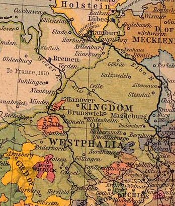
Nederlands: Koninkrijk Westfalen |
||||||||||||||||||||||
| תאריך יצירה | |||||||||||||||||||||||
| מקור | From The Historical Atlas by William R. Shepherd, 1926. | ||||||||||||||||||||||
| יוצר |
|
||||||||||||||||||||||
| אישורים והיתרים (שימוש חוזר בקובץ זה) |
PCL states map is PD | ||||||||||||||||||||||
רישיון
היוצר נפטר בשנת 1934, לכן יצירה זו נמצאת בנחלת הכלל במדינת המקור ובמדינות אחרות בהם תקופת זכויות היוצרים היא משך חיי היוצר ו-80 שנה (או פחות) מפטירתו.
| |
| הקובץ הזה זוהה כקובץ חופשי מכל מגבלה ידועה תחת חוק זכויות היוצרים, כולל כל הזכויות הקשורות והסמוכות. | |
This work is in the public domain because it was published in the United States between 1929 and 1963, and although there may or may not have been a copyright notice, the copyright was not renewed. For further explanation, see Commons:Hirtle chart and the copyright renewal logs. Note that it may still be copyrighted in jurisdictions that do not apply the rule of the shorter term for US works (depending on the date of the author's death), such as Canada (70 years p.m.a.), Mainland China (50 years p.m.a., not Hong Kong or Macao), Germany (70 years p.m.a.), Mexico (100 years p.m.a.), Switzerland (70 years p.m.a.), and other countries with individual treaties.
|
 |
יומן העלאה מקורי
- Originally from nl.wikipedia; description page is/was here.
(All user names refer to nl.wikipedia)
- 2004-08-16 09:49 Känsterle 348×409×8 (69732 bytes) Koninkrijk Westfalen - vrij te gebruiken voor educatieve doeleinden - http://www.lib.utexas.edu/maps/historical/
Map of the principality (later free state) of Lippe 1815–1945. From German Wikipedia and according to information there "Gemeinfrei" = public domain. {{PD-user|Störfix}}
היסטוריית הקובץ
ניתן ללחוץ על תאריך/שעה כדי לראות את הקובץ כפי שנראה באותו זמן.
| תאריך/שעה | תמונה ממוזערת | ממדים | משתמש | הערה | |
|---|---|---|---|---|---|
| נוכחית | 12:38, 4 במרץ 2007 | | 409 × 348 (68 ק"ב) | SieBot | {{Information |Description=Koninkrijk Westfalen {{PD-PCL|central_europe_1812.jpg|historical/shepherd/}} |Source=Originally from [http://nl.wikipedia.org nl.wikipedia]; description page is/was [http://nl.wikipedia.org/w/index.php?title=Image%3AKWestfale |
שימוש בקובץ
הדף הבא משתמש בקובץ הזה:
שימוש גלובלי בקובץ
אתרי הוויקי השונים הבאים משתמשים בקובץ זה:
- שימוש באתר ca.wikipedia.org
- שימוש באתר el.wikipedia.org
- שימוש באתר eo.wikipedia.org
- שימוש באתר et.wikipedia.org
- שימוש באתר fa.wikipedia.org
- שימוש באתר id.wikipedia.org
- שימוש באתר it.wikipedia.org
- שימוש באתר ro.wikipedia.org
- שימוש באתר sr.wikipedia.org
- שימוש באתר zh.wikipedia.org