
קובץ:Map and sketches of Easter Island, in 1772-5.jpg
גודל התצוגה המקדימה הזאת: 368 × 600 פיקסלים. רזולוציות אחרות: 147 × 240 פיקסלים | 294 × 480 פיקסלים | 700 × 1,141 פיקסלים.
לקובץ המקורי (700 × 1,141 פיקסלים, גודל הקובץ: 546 ק"ב, סוג MIME: image/jpeg)
| זהו קובץ שמקורו במיזם ויקישיתוף. תיאורו בדף תיאור הקובץ המקורי (בעברית) מוצג למטה. |
תקציר
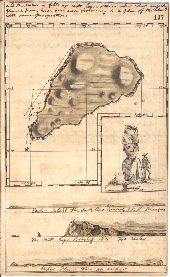
| תיאור | Map and sketches of Easter Island from J Gilbert's log of the voyage of HMS Resolution through the Pacific from 1772-5. This image is from the collections of The National Archives.Image no.3755157 . |
| תאריך יצירה | UTC |
| מקור | Easter Island |
| יוצר | The National Archives UK |
רישיון
This image was taken from Flickr's The Commons. The uploading organization may have various reasons for determining that no known copyright restrictions exist, such as:
More information can be found at https://flickr.com/commons/usage/. Please add additional copyright tags to this image if more specific information about copyright status can be determined. See Commons:Licensing for more information. |
| This image was originally posted to Flickr by The National Archives UK at https://www.flickr.com/photos/31575009@N05/3362174249. It was reviewed on 15:15, 16 October 2010 (UTC) by FlickreviewR, who found it to be licensed under the terms of the No known copyright restrictions, which is compatible with the Commons. It is, however, not the same license as given above, and it is unknown whether that license ever was valid. |
file information
- Date: c.1773
- Catalogue Reference: ADM 55/107 f.137
- URL visited:Image library.
היסטוריית הקובץ
ניתן ללחוץ על תאריך/שעה כדי לראות את הקובץ כפי שנראה באותו זמן.
| תאריך/שעה | תמונה ממוזערת | ממדים | משתמש | הערה | |
|---|---|---|---|---|---|
| נוכחית | 17:25, 16 באוקטובר 2010 | | 1,141 × 700 (546 ק"ב) | Alpha30 | {{Information |Description= '''Map and sketches of Easter Island''' from J Gilbert's log of the voyage of HMS Resolution through the Pacific from '''1772-5'''. This image is from the collections of The National Archives.Image no.3755157 . |Source=[http:// |
שימוש בקובץ
הדף הבא משתמש בקובץ הזה:
שימוש גלובלי בקובץ
אתרי הוויקי השונים הבאים משתמשים בקובץ זה:
- שימוש באתר www.mediawiki.org