
קובץ:Princes Islands.png

גודל התצוגה המקדימה הזאת: 741 × 600 פיקסלים. רזולוציות אחרות: 297 × 240 פיקסלים | 593 × 480 פיקסלים | 777 × 629 פיקסלים.
לקובץ המקורי (777 × 629 פיקסלים, גודל הקובץ: 1.01 מ"ב, סוג MIME: image/png)
| זהו קובץ שמקורו במיזם ויקישיתוף. תיאורו בדף תיאור הקובץ המקורי (בעברית) מוצג למטה. |
תקציר
| תיאור |
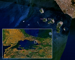
Ελληνικά: Δορυφορική φωτογραφία των Πριγκηπονησίων, Θάλασσα του Μαρμαρά |
| מקור | נוצר על־ידי מעלה היצירה |
| יוצר | Duja |
Source
Own work, based on public-domain en:Landsat imagery using en:NASA WorldWind.
Author
רישיון
אני, בעל זכויות היוצרים על היצירה הזאת, מפרסם אותה בזאת תחת הרישיונות הבאים:

|
מוענקת בכך הרשות להעתיק, להפיץ או לשנות את המסמך הזה, לפי תנאי הרישיון לשימוש חופשי במסמכים של גנו, גרסה 1.2 או כל גרסה מאוחרת יותר שתפורסם על־ידי המוסד לתוכנה חופשית; ללא פרקים קבועים, ללא טקסט עטיפה קדמית וללא טקסט עטיפה אחורית. עותק של הרישיון כלול בפרק שכותרתו הרישיון לשימוש חופשי במסמכים של גנו. |
| הקובץ הזה מתפרסם לפי תנאי רישיון קריאייטיב קומונז ייחוס-שיתוף זהה 3.0 לא מותאם. | ||
| ||
| תבנית רישוי זו הוספה לקובץ כחלק מעדכון רישיון GFDL. |
הנכם מוזמנים לבחור את הרישיון הרצוי בעיניכם.
| קובץ זה בנחלת הכלל כי הוא צילום מסך מתוכנת תוכנת הגלובוס של נאס"א, שעושה שימוש במרכיבים שנמצאים ברשות הציבור כמו: The Blue Marble, MODIS, Landsat, SRTM, USGS או GLOBE.
|
 |
היסטוריית הקובץ
ניתן ללחוץ על תאריך/שעה כדי לראות את הקובץ כפי שנראה באותו זמן.
| תאריך/שעה | תמונה ממוזערת | ממדים | משתמש | הערה | |
|---|---|---|---|---|---|
| נוכחית | 12:38, 19 בפברואר 2007 | | 629 × 777 (1.01 מ"ב) | Duja | |
| 12:29, 19 בפברואר 2007 |  | 629 × 777 (1.02 מ"ב) | Duja | ==Description== Satellite map of en:Princes' Islands, with a wider map of en:Sea of Marmara ==Source== Own work, based on public-domain Landsat imagery using NASA WorldWind. ==Author== User:Duja ==License== {{GFDL-self}} [[Catego |
שימוש בקובץ
הדף הבא משתמש בקובץ הזה:
שימוש גלובלי בקובץ
אתרי הוויקי השונים הבאים משתמשים בקובץ זה:
- שימוש באתר az.wikipedia.org
- שימוש באתר bg.wikipedia.org
- שימוש באתר ca.wikipedia.org
- שימוש באתר ceb.wikipedia.org
- שימוש באתר ce.wikipedia.org
- שימוש באתר cs.wikipedia.org
- שימוש באתר de.wikivoyage.org
- שימוש באתר diq.wikipedia.org
- שימוש באתר el.wikipedia.org
- שימוש באתר en.wikipedia.org
- שימוש באתר eo.wikipedia.org
- שימוש באתר es.wikipedia.org
- שימוש באתר fi.wikipedia.org
- שימוש באתר fr.wikipedia.org
- שימוש באתר gl.wikipedia.org
- שימוש באתר he.wikivoyage.org
- שימוש באתר hy.wikipedia.org
- שימוש באתר id.wikipedia.org
- שימוש באתר it.wikipedia.org
- שימוש באתר ka.wikipedia.org
- שימוש באתר ko.wikipedia.org
- שימוש באתר mk.wikipedia.org
- שימוש באתר mrj.wikipedia.org
- שימוש באתר nn.wikipedia.org
- שימוש באתר pl.wikipedia.org
- שימוש באתר ro.wikipedia.org