
קובץ:Sunda strait map v4.png
אין גרסה ברזולוציה גבוהה יותר.
Sunda_strait_map_v4.png (487 × 351 פיקסלים, גודל הקובץ: 176 ק"ב, סוג MIME: image/png)
| זהו קובץ שמקורו במיזם ויקישיתוף. תיאורו בדף תיאור הקובץ המקורי (בעברית) מוצג למטה. |
תקציר
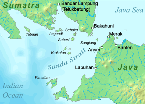
| תיאור |
Deutsch: Karte der Sundastraße, Indonesien
English: Map of the Sunda Strait, Indonesia |
||||
| תאריך יצירה | |||||
| מקור | נוצר על־ידי מעלה היצירה | ||||
| יוצר | Telim tor | ||||
| אישורים והיתרים (שימוש חוזר בקובץ זה) |
|
||||
| גרסאות אחרות |

היסטוריית הקובץ
ניתן ללחוץ על תאריך/שעה כדי לראות את הקובץ כפי שנראה באותו זמן.
| תאריך/שעה | תמונה ממוזערת | ממדים | משתמש | הערה | |
|---|---|---|---|---|---|
| נוכחית | 14:37, 23 בינואר 2011 | | 351 × 487 (176 ק"ב) | Telim tor | == {{int:filedesc}} == {{Information |Description={{en|Map of the Sunda Strait, Indonesia}} |Source={{own}} |Date=2011-01-23 |Author=Telim tor |Permission={{PD-Demis}} |other_versions=={{Extracted from|Sunda_strait_map_v3.png}} }} [[Ca |
שימוש בקובץ
![]() אין בוויקיפדיה דפים המשתמשים בקובץ זה.
אין בוויקיפדיה דפים המשתמשים בקובץ זה.
שימוש גלובלי בקובץ
אתרי הוויקי השונים הבאים משתמשים בקובץ זה:
- שימוש באתר ar.wikipedia.org
- שימוש באתר de.wikipedia.org
- שימוש באתר en.wikipedia.org
- שימוש באתר id.wikipedia.org
- שימוש באתר it.wikipedia.org
- שימוש באתר ka.wikipedia.org
- שימוש באתר nl.wikipedia.org
- שימוש באתר no.wikipedia.org
- שימוש באתר sh.wikipedia.org
- שימוש באתר uk.wikipedia.org
- שימוש באתר zh-yue.wikipedia.org