
קובץ:Waldseemuller map, complete.jpg

גודל התצוגה המקדימה הזאת: 800 × 444 פיקסלים. רזולוציות אחרות: 320 × 178 פיקסלים | 640 × 356 פיקסלים | 1,024 × 569 פיקסלים | 1,280 × 711 פיקסלים | 2,560 × 1,422 פיקסלים | 29,700 × 16,500 פיקסלים.
לקובץ המקורי (29,700 × 16,500 פיקסלים, גודל הקובץ: 97.97 מ"ב, סוג MIME: image/jpeg)
| זהו קובץ שמקורו במיזם ויקישיתוף. תיאורו בדף תיאור הקובץ המקורי (בעברית) מוצג למטה. |
| Warning | The original file is very high-resolution. It might not load properly or could cause your browser to freeze when opened at full size. |
|---|
תקציר
| תיאור |
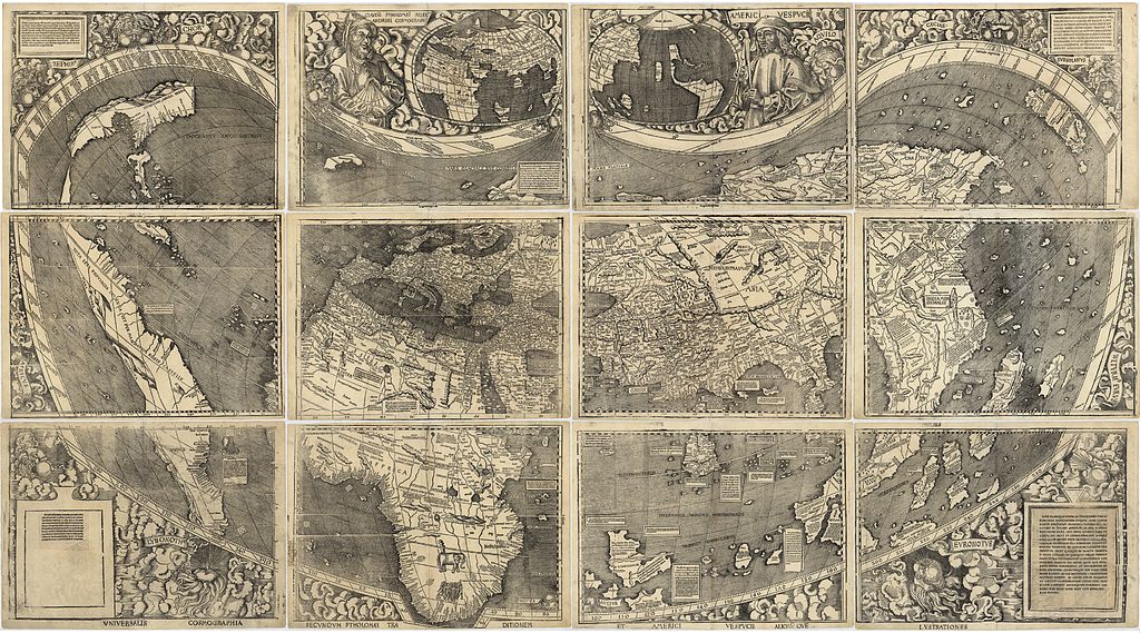
The Waldseemüller map, the first map to include the name "America" and the first to depict the Americas as separate from Asia. The map comprises 12 separate sheets, shown here into a single image. There is only one surviving copy of the map, which was purchased by the Library of Congress in 2001 for $10 million. Its Latin title is "Universalis cosmographia secundum Ptholomaei traditionem et Americi Vespucii alioru[m]que lustrationes". Converted from the LoC's JPEG2000 file to JPEG using ImageMagick with 81% quality (to fit under the current 100MB upload limit on Wikimedia Commons). |
|||||||||||||||||||||||
| תאריך יצירה | ||||||||||||||||||||||||
| מקור | file, description. | |||||||||||||||||||||||
| יוצר |
|
|||||||||||||||||||||||
| גרסאות אחרות |
|
|||||||||||||||||||||||


רישיון
|
יצירה זו נמצאת בנחלת הכלל במדינת המקור ובמדינות אחרות בהם תקופת זכויות היוצרים היא משך חיי היוצר ו-100 שנה (או פחות) מפטירתו.
| |
| הקובץ הזה זוהה כקובץ חופשי מכל מגבלה ידועה תחת חוק זכויות היוצרים, כולל כל הזכויות הקשורות והסמוכות. | |
היסטוריית הקובץ
ניתן ללחוץ על תאריך/שעה כדי לראות את הקובץ כפי שנראה באותו זמן.
| תאריך/שעה | תמונה ממוזערת | ממדים | משתמש | הערה | |
|---|---|---|---|---|---|
| נוכחית | 03:06, 26 במאי 2011 | | 16,500 × 29,700 (97.97 מ"ב) | Avenue | {{LargeImage}} == {{int:filedesc}} == {{Information |Description=The Waldseemüller map, the first map to include the name "America" and the first to depict the Americas as separate from Asia. The map comprises 12 separate she |
שימוש בקובץ
![]() אין בוויקיפדיה דפים המשתמשים בקובץ זה.
אין בוויקיפדיה דפים המשתמשים בקובץ זה.