
קובץ:1820 Виленская Губерния.jpg

לקובץ המקורי (4,908 × 4,739 פיקסלים, גודל הקובץ: 20.13 מ"ב, סוג MIME: image/jpeg)
| זהו קובץ שמקורו במיזם ויקישיתוף. תיאורו בדף תיאור הקובץ המקורי (בעברית) מוצג למטה. |
תקציר
| תיאור |
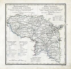
English: Geographic atlas of the Russian Empire, Kingdom of Poland and Grand Duchy of Finland is located in governorates in the Russian and French. 1821.
Русский: Географический атлас Российской империи, Царства Польского и Великого княжества Финляндского расположенный по губерниям на русском и французском языках. 1821 год. Виленская Губерния. Генеральная карта.
Français : Atlas Geografique de L Empire de Russie, du Royaume de Pologne et du Grand Duche de Finlande divise en Gouvernemens. Mappa Generalna Gubernii Wilenskiey. 1821. |
| תאריך יצירה | |
| מקור | http://rutracker.org/forum/viewtopic.php?t=600838 |
| יוצר | Пядышев, Военно-Картографическое Депо |
רישיון
|
יצירה זו נמצאת בנחלת הכלל במדינת המקור ובמדינות אחרות בהם תקופת זכויות היוצרים היא משך חיי היוצר ו-70 שנה (או פחות) מפטירתו.
| |
| הקובץ הזה זוהה כקובץ חופשי מכל מגבלה ידועה תחת חוק זכויות היוצרים, כולל כל הזכויות הקשורות והסמוכות. | |
היסטוריית הקובץ
ניתן ללחוץ על תאריך/שעה כדי לראות את הקובץ כפי שנראה באותו זמן.
| תאריך/שעה | תמונה ממוזערת | ממדים | משתמש | הערה | |
|---|---|---|---|---|---|
| נוכחית | 12:53, 28 במרץ 2009 | | 4,739 × 4,908 (20.13 מ"ב) | Berillium | {{Information |Description={{en|1=Geographic atlas of the Russian Empire, Kingdom of Poland and Grand Duchy of Finland is located in governorates in the Russian and French. 1821.}} {{ru|1=Географический атлас Российской имп |
שימוש בקובץ
הדף הבא משתמש בקובץ הזה:
שימוש גלובלי בקובץ
אתרי הוויקי השונים הבאים משתמשים בקובץ זה:
- שימוש באתר be.wikipedia.org
- שימוש באתר et.wikipedia.org
- שימוש באתר fi.wikipedia.org
- שימוש באתר lt.wikipedia.org
- שימוש באתר lt.wikibooks.org
- שימוש באתר lv.wikipedia.org
- שימוש באתר pl.wikipedia.org
- שימוש באתר ru.wikipedia.org