
קובץ:1846 Mitchell's Map of Texas Oregon and California - Geographicus - TXORCA-mitchell-1846.jpg
גודל התצוגה המקדימה הזאת: 553 × 599 פיקסלים. רזולוציות אחרות: 221 × 240 פיקסלים | 443 × 480 פיקסלים | 708 × 768 פיקסלים | 945 × 1,024 פיקסלים | 1,889 × 2,048 פיקסלים | 5,000 × 5,420 פיקסלים.
לקובץ המקורי (5,000 × 5,420 פיקסלים, גודל הקובץ: 5.64 מ"ב, סוג MIME: image/jpeg)
| זהו קובץ שמקורו במיזם ויקישיתוף. תיאורו בדף תיאור הקובץ המקורי (בעברית) מוצג למטה. |
| Samuel Augustus Mitchell: A New Map of Texas, Oregon and California with the Regions Adjoining.
( |
||||||||||||||||||||
|---|---|---|---|---|---|---|---|---|---|---|---|---|---|---|---|---|---|---|---|---|
| אומן |
|
|||||||||||||||||||
| כותרת |
A New Map of Texas, Oregon and California with the Regions Adjoining. |
|||||||||||||||||||
| תיאור |
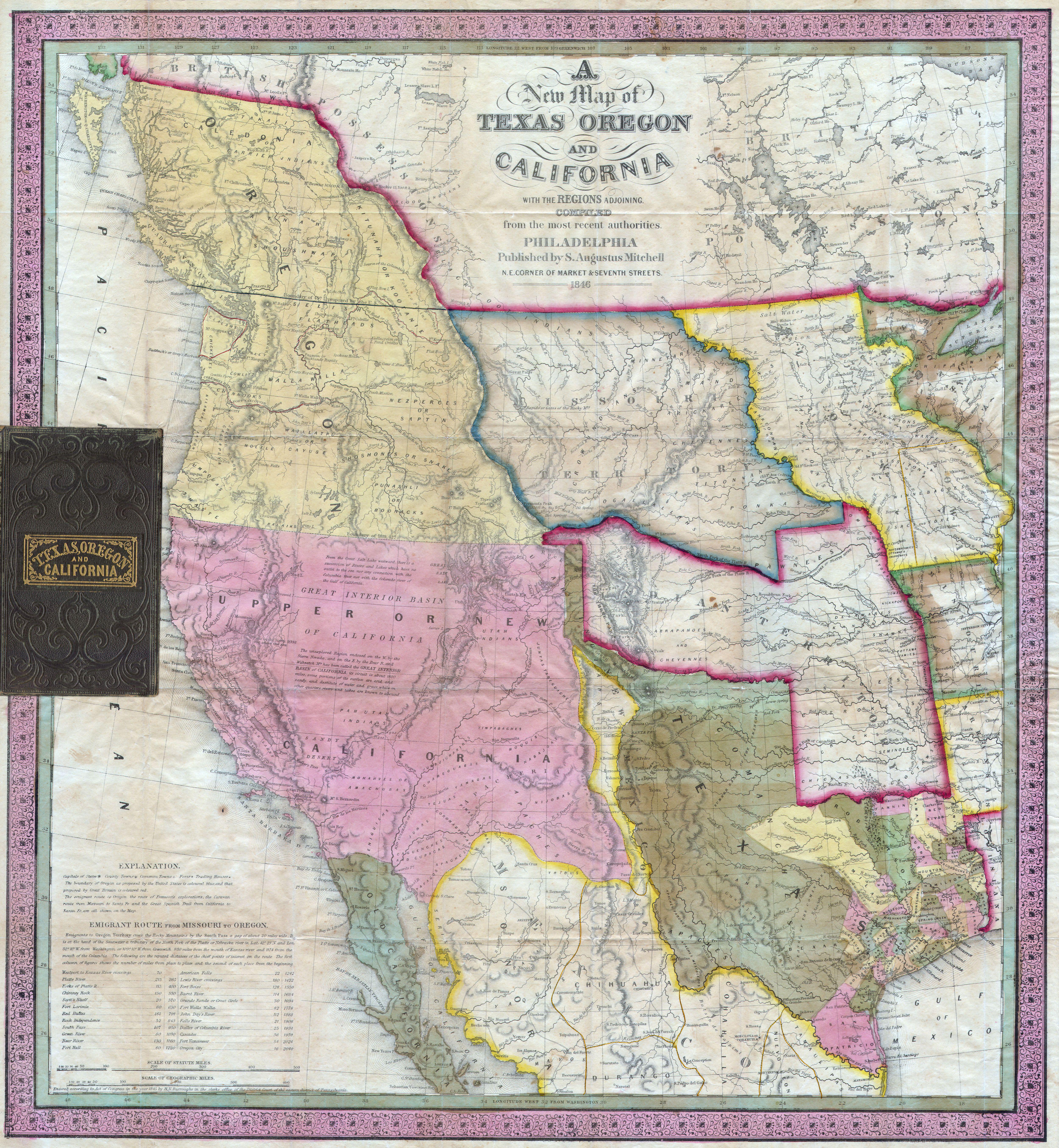
English: A stunning example of Mitchell’s seminal 1846 pocket map of Texas, Oregon, Upper California, Missouri Territory, the Indian Territory (Oklahoma, though in this example including most of Kansas and Colorado). This important map of Texas is one of the first widely-circulated maps of the early statehood period. This map shows the borders of Texas extending to Santa Fe. Also includes Texas’ claim to the Upper Rio Grande in present day New Mexico. These claims were eventually given up in the 1850 “Great Compromise”, wherein the U.S. Federal Government assumed Texas’ public debt. To make this map Mitchell compiled the mappings of Arrowsmith (1841), Fremont, Emory, Wilkes, and Nicollet, as well as making use of data from the Louis & Clark expedition. This map was very popular when issued due to general interest in the new state of Texas as well as the Mexican-American war, which started the same year the map was issued. Brigham Young, the Mormon Moses, famously ordered six copies of this map when planning the 1847 Mormon migration west. One of the most important maps in American history. Accompanied by a 46 page text entitled Accompaniment to Mitchell’s New Map of Texas, Oregon and California, includes among the best contemporary descriptions of Oregon and California . Removed from but accompanied by the original 16mo gilt-lettered roan folder. |
|||||||||||||||||||
| תאריך יצירה | 1846 (dated) | |||||||||||||||||||
| ממדים | גובה: 22.5 in (57.1 ס"מ); רוחב: 21 in (53.3 ס"מ) | |||||||||||||||||||
| מספר גישה |
Geographicus link: TXORCA-mitchell-1846 |
|||||||||||||||||||
| מקור/צלם |
|
|||||||||||||||||||
| אישורים והיתרים (שימוש חוזר בקובץ זה) |
|
|||||||||||||||||||
היסטוריית הקובץ
ניתן ללחוץ על תאריך/שעה כדי לראות את הקובץ כפי שנראה באותו זמן.
| תאריך/שעה | תמונה ממוזערת | ממדים | משתמש | הערה | |
|---|---|---|---|---|---|
| נוכחית | 09:23, 24 במרץ 2011 | | 5,420 × 5,000 (5.64 מ"ב) | BotMultichillT | {{subst:User:Multichill/Geographicus |link=http://www.geographicus.com/P/AntiqueMap/TXORCA-mitchell-1846 |product_name=1846 Mitchell's Map of Texas Oregon and California |map_title=A New Map of Texas, Oregon and California with the Regions Adjoining. |des |
שימוש בקובץ
הדף הבא משתמש בקובץ הזה:
שימוש גלובלי בקובץ
אתרי הוויקי השונים הבאים משתמשים בקובץ זה:
- שימוש באתר en.wikipedia.org
- שימוש באתר ru.wikipedia.org
- שימוש באתר tr.wikipedia.org