
קובץ:Achaemenid Empire 500 BC.png

גודל התצוגה המקדימה הזאת: 800 × 427 פיקסלים. רזולוציות אחרות: 320 × 171 פיקסלים | 640 × 341 פיקסלים | 1,024 × 546 פיקסלים | 1,280 × 683 פיקסלים | 3,070 × 1,637 פיקסלים.
לקובץ המקורי (3,070 × 1,637 פיקסלים, גודל הקובץ: 811 ק"ב, סוג MIME: image/png)
| זהו קובץ שמקורו במיזם ויקישיתוף. תיאורו בדף תיאור הקובץ המקורי (בעברית) מוצג למטה. |
תקציר
| תיאור |
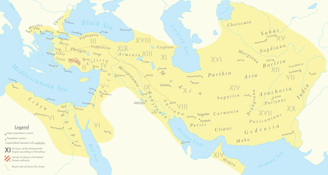
English: A map of the Achaemenid Empire around 500 BC featuring ancient regions, settlements and Satrapies. This map assembles information from the Historischer Schul-Atlas zur alten, mittleren und neueren Geschichte by Heinrich Kiepert and Carl Wolff from 1879 as accessed from GEI Digital, the 1923 edition of Historical Atlas by William R. Shepherd as accessed from the Perry-Castañeda Library's online map collection and Livius.org's article on the Satrapies of the Achaemenid Empire according to Herodotus. |
| תאריך יצירה | |
| מקור | נוצר על־ידי מעלה היצירה |
| יוצר | Cattette |
רישיון
אני, בעל זכויות היוצרים על עבודה זו, מפרסם בזאת את העבודה תחת הרישיון הבא:
קובץ זה מופיע תחת רישיון Creative Commons ייחוס 4.0 בינלאומי.
- הנכם רשאים:
- לשתף – להעתיק, להפיץ ולהעביר את העבודה
- לערבב בין עבודות – להתאים את העבודה
- תחת התנאים הבאים:
- ייחוס – יש לתת ייחוס הולם, לתת קישור לרישיון, ולציין אם נעשו שינויים. אפשר לעשות את זה בכל צורה סבירה, אבל לא בשום צורה שמשתמע ממנה שמעניק הרישיון תומך בך או בשימוש שלך.
היסטוריית הקובץ
ניתן ללחוץ על תאריך/שעה כדי לראות את הקובץ כפי שנראה באותו זמן.
| תאריך/שעה | תמונה ממוזערת | ממדים | משתמש | הערה | |
|---|---|---|---|---|---|
| נוכחית | 10:01, 12 במרץ 2021 | | 1,637 × 3,070 (811 ק"ב) | Cattette | Changed terminology, added Cyropolis |
| 09:05, 9 במרץ 2021 |  | 1,637 × 3,070 (811 ק"ב) | Cattette | Added more cities | |
| 00:52, 9 במרץ 2021 |  | 1,637 × 3,070 (807 ק"ב) | Cattette | Removed anachronistic labels, removed Thrace and Macedonia as Satrapies | |
| 23:44, 8 במרץ 2021 |  | 1,637 × 3,070 (813 ק"ב) | Cattette | Fixed north eastern border, tweaked satrapies | |
| 21:55, 8 במרץ 2021 |  | 1,637 × 3,070 (794 ק"ב) | Cattette | Tweaked borders and satraps | |
| 18:20, 8 במרץ 2021 |  | 1,637 × 3,070 (789 ק"ב) | Cattette | Fixed Indian border again, added cities in Greece | |
| 10:02, 8 במרץ 2021 |  | 1,637 × 3,070 (785 ק"ב) | Cattette | Stronger color, capitals, more cities, added Indian territories beyond the Indus | |
| 17:26, 7 במרץ 2021 |  | 1,637 × 2,923 (729 ק"ב) | Cattette | Uploaded own work with UploadWizard |
שימוש בקובץ
הדפים הבאים משתמשים בקובץ הזה:
שימוש גלובלי בקובץ
אתרי הוויקי השונים הבאים משתמשים בקובץ זה:
- שימוש באתר arz.wikipedia.org
- שימוש באתר ast.wikipedia.org
- שימוש באתר ceb.wikipedia.org
- שימוש באתר cs.wikipedia.org
- שימוש באתר en.wikipedia.org
- שימוש באתר fa.wikipedia.org
- שימוש באתר ga.wikipedia.org
- שימוש באתר gl.wikipedia.org
- שימוש באתר ha.wikipedia.org
- שימוש באתר ko.wikipedia.org
- שימוש באתר ku.wikipedia.org
- שימוש באתר pl.wikipedia.org
- שימוש באתר tg.wikipedia.org
- שימוש באתר www.wikidata.org