
קובץ:Aegadian Islands map.png
אין גרסה ברזולוציה גבוהה יותר.
Aegadian_Islands_map.png (690 × 528 פיקסלים, גודל הקובץ: 112 ק"ב, סוג MIME: image/png)
| זהו קובץ שמקורו במיזם ויקישיתוף. תיאורו בדף תיאור הקובץ המקורי (בעברית) מוצג למטה. |
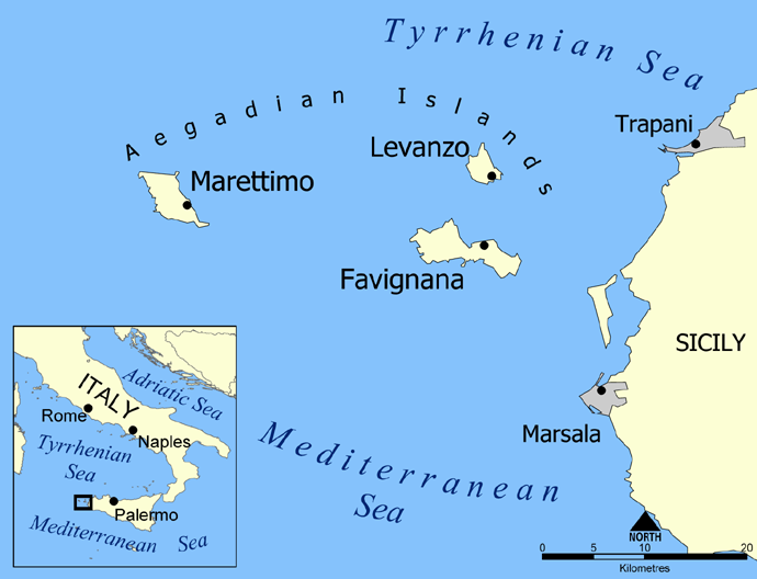
Map of the Aegadian Islands showing the islands of Favignana, Levanzo, and Marettimo, and the nearby port cities of Trapani and Marsala, Sicily.
Blank version available at Image:Aegadian Islands blank map.png.
Created by NormanEinstein, May 19, 2005.
| ברצוני, בעלי זכויות היוצרים על יצירה זו, לשחרר יצירה זו לנחלת הכלל. זה תקף בכל העולם. יש מדינות שבהן הדבר אינו אפשרי על פי חוק, אם כך: אני מעניק לכל אחד את הזכות להשתמש בעבודה זו לכל מטרה שהיא, ללא תנאים כלשהם, אלא אם כן תנאים כאלה נדרשים על פי חוק. |
היסטוריית הקובץ
ניתן ללחוץ על תאריך/שעה כדי לראות את הקובץ כפי שנראה באותו זמן.
| תאריך/שעה | תמונה ממוזערת | ממדים | משתמש | הערה | |
|---|---|---|---|---|---|
| נוכחית | 01:24, 27 בפברואר 2016 | | 528 × 690 (112 ק"ב) | Ras67 | black frame removed, opt. |
| 16:58, 19 במאי 2005 |  | 538 × 700 (150 ק"ב) | NormanEinstein | Map of the Aegadian Islands showing the islands of Favignana, Levanzo, and Marettimo, and the nearby port cities of Trapani and Marsala, Sicily. Created by NormanEinstein, May 19, 2005. {{PD-self}} |
שימוש בקובץ
הדף הבא משתמש בקובץ הזה:
שימוש גלובלי בקובץ
אתרי הוויקי השונים הבאים משתמשים בקובץ זה:
- שימוש באתר ar.wikipedia.org
- שימוש באתר be.wikipedia.org
- שימוש באתר bg.wikipedia.org
- שימוש באתר bs.wikipedia.org
- שימוש באתר ca.wikipedia.org
- שימוש באתר cs.wikipedia.org
- שימוש באתר da.wikipedia.org
- שימוש באתר de.wikipedia.org
- שימוש באתר el.wikipedia.org
- שימוש באתר en.wikipedia.org
- שימוש באתר en.wiktionary.org
- שימוש באתר eo.wikipedia.org
- שימוש באתר fa.wikipedia.org
- שימוש באתר fi.wikipedia.org
- שימוש באתר fr.wikipedia.org
- שימוש באתר fr.wiktionary.org
- שימוש באתר fy.wikipedia.org
- שימוש באתר gl.wikipedia.org
- שימוש באתר id.wikipedia.org