
קובץ:Anglo.Saxon.migration.5th.cen.jpg
לקובץ המקורי (1,800 × 1,703 פיקסלים, גודל הקובץ: 875 ק"ב, סוג MIME: image/jpeg)
| זהו קובץ שמקורו במיזם ויקישיתוף. תיאורו בדף תיאור הקובץ המקורי (בעברית) מוצג למטה. |

|
יש ליצור מחדש את התמונה historical map הזו באמצעות גרפיקה וקטורית כדוגמת קובץ SVG. לפעולה זו מספר יתרונות, כפי שניתן לקרוא (באנגלית) בדף Commons:Media for cleanup. אם ברשותכם קובץ SVG, אנא העלו אותו. לאחר מכן, החליפו תבנית זו בתבנית
{{vector version available|שם הקובץ.svg}} |


תקציר
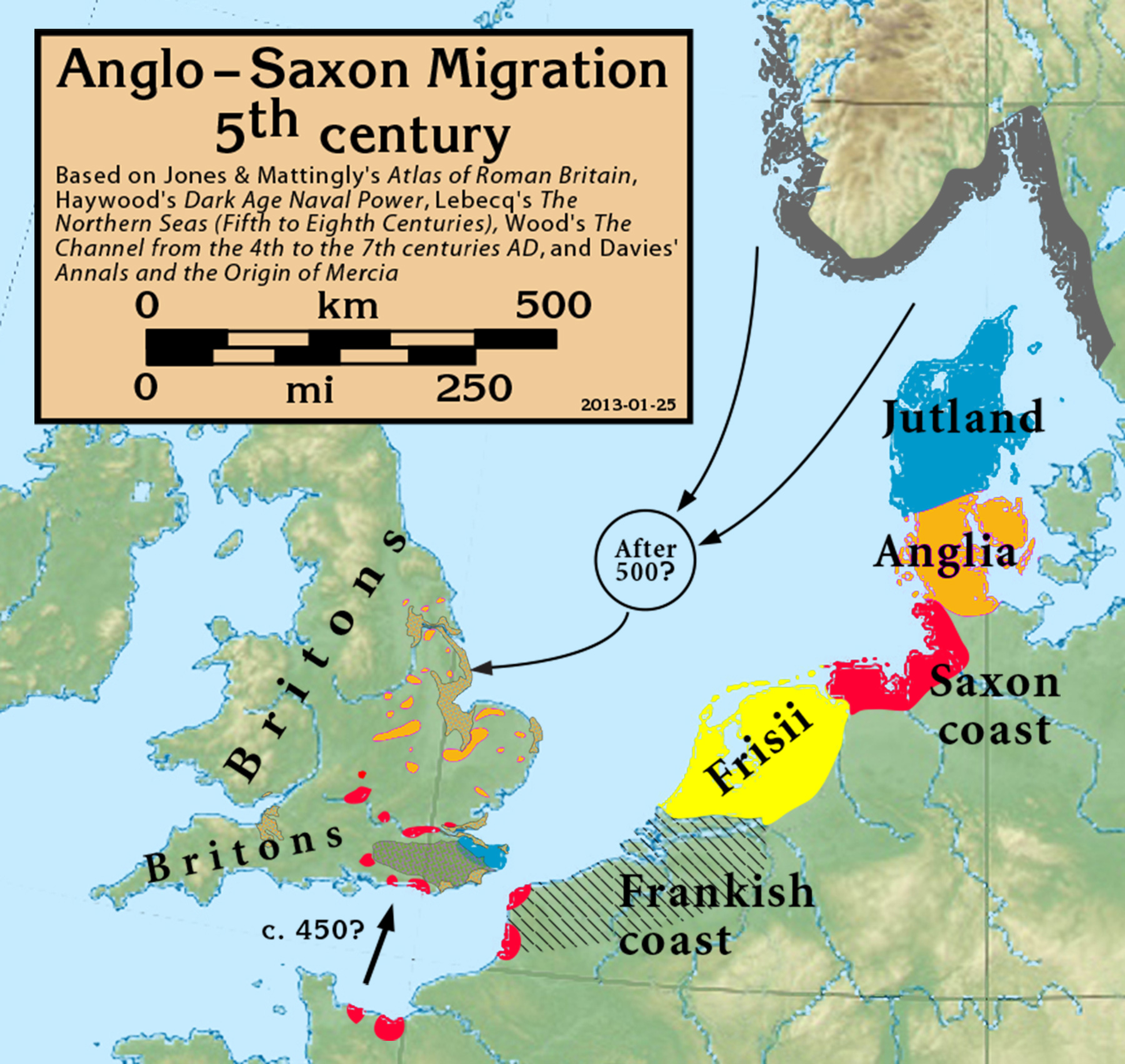
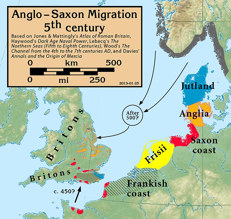
| תיאור | Anglo-Saxon Migration in the 5th century |
| תאריך יצירה | |
| מקור |
Based on Jones & Mattingly's Atlas of Roman Britain (ISBN 978-1-84217-06700, 1990, reprinted 2007, pp. 317, 318), Haywood's Dark Age Naval Power (ISBN 1-898281-43-2, 1999, cemeteries on pp. 84–86, 121, region of "Romanisation" on p. 151), Lebecq's The Northern Seas (fifth to eighth centuries) (in The New Cambridge Medieval History, Vol I c.500–c.700, ISBN 13-978-0-521-36291-7, 2005, p. 643), and Wood's The Channel from the 4th to the 7th centuries AD in Carver's Maritime Celts, Frisians and Saxons (ISBN 978-0906780930, pp 93–97). The suggestion that settlements in Britain were made from the Bessin is from Haywood (Vron, for example, was abandoned c. 450). Jones & Mattingly also show 5th century cemeteries in the central English Midlands south of the River Trent, based on the dating of excavated cemeteries, but this is disputed by historians arguing for a 6th century Anglo-Saxon expansion into that region (see, for example Annals and the Origin of Mercia, pp. 20–24, by Wendy Davies, in Mercian Studies, 1977, ISBN 0718511484).
|
| יוצר | my work |
רישיון
- הנכם רשאים:
- לשתף – להעתיק, להפיץ ולהעביר את העבודה
- לערבב בין עבודות – להתאים את העבודה
- תחת התנאים הבאים:
- ייחוס – יש לתת ייחוס הולם, לתת קישור לרישיון, ולציין אם נעשו שינויים. אפשר לעשות את זה בכל צורה סבירה, אבל לא בשום צורה שמשתמע ממנה שמעניק הרישיון תומך בך או בשימוש שלך.
- שיתוף זהה – אם תיצרו רמיקס, תשנו, או תבנו על החומר, חובה עליכם להפיץ את התרומות שלך לפי תנאי רישיון זהה או תואם למקור.
היסטוריית הקובץ
ניתן ללחוץ על תאריך/שעה כדי לראות את הקובץ כפי שנראה באותו זמן.
| תאריך/שעה | תמונה ממוזערת | ממדים | משתמש | הערה | |
|---|---|---|---|---|---|
| נוכחית | 20:05, 27 בספטמבר 2021 | | 1,703 × 1,800 (875 ק"ב) | GPinkerton | Reverted to version as of 16:39, 25 January 2013 (UTC) COM:CROP |
| 18:57, 19 במאי 2020 |  | 1,703 × 1,800 (885 ק"ב) | Claude Zygiel | Shoreline (high tide) of this time + Flevo lake (the british bank of North Sea was lower but in tectonic rise, the continental bank was upper but in subsidence) | |
| 19:39, 25 בינואר 2013 |  | 1,703 × 1,800 (875 ק"ב) | Notuncurious | minor cleanup and improvement | |
| 23:29, 24 בינואר 2013 |  | 2,451 × 2,635 (932 ק"ב) | Notuncurious | User created page with UploadWizard |
שימוש בקובץ
הדף הבא משתמש בקובץ הזה:
שימוש גלובלי בקובץ
אתרי הוויקי השונים הבאים משתמשים בקובץ זה:
- שימוש באתר ar.wikipedia.org
- שימוש באתר arz.wikipedia.org
- שימוש באתר azb.wikipedia.org
- שימוש באתר br.wikipedia.org
- שימוש באתר ca.wikipedia.org
- שימוש באתר cs.wikipedia.org
- שימוש באתר de.wikipedia.org
- שימוש באתר en.wikipedia.org
- שימוש באתר es.wikipedia.org
- שימוש באתר et.wikipedia.org
- שימוש באתר eu.wikipedia.org
- שימוש באתר fi.wikipedia.org
- שימוש באתר fr.wikipedia.org
- שימוש באתר fy.wikipedia.org
- שימוש באתר ga.wikipedia.org
- שימוש באתר hr.wikipedia.org
- שימוש באתר hu.wikipedia.org
- שימוש באתר hy.wikipedia.org
- שימוש באתר id.wikipedia.org
- שימוש באתר it.wikipedia.org
- שימוש באתר mk.wikipedia.org
- שימוש באתר ms.wikipedia.org
- שימוש באתר nl.wikipedia.org
- שימוש באתר pl.wikipedia.org
- שימוש באתר pt.wikipedia.org
- שימוש באתר ru.wikipedia.org
- שימוש באתר sh.wikipedia.org
- שימוש באתר simple.wikipedia.org
- שימוש באתר sk.wikipedia.org
- שימוש באתר sl.wikipedia.org
- שימוש באתר sr.wikipedia.org