
קובץ:Antarctica, Norway territorial claim.svg

גודל התצוגה המקדימה הזאת מסוג PNG של קובץ ה־SVG הזה: 600 × 600 פיקסלים. רזולוציות אחרות: 240 × 240 פיקסלים | 480 × 480 פיקסלים | 768 × 768 פיקסלים | 1,024 × 1,024 פיקסלים | 2,048 × 2,048 פיקסלים | 806 × 806 פיקסלים.
לקובץ המקורי (קובץ SVG, הגודל המקורי: 806 × 806 פיקסלים, גודל הקובץ: 65 ק"ב)
| זהו קובץ שמקורו במיזם ויקישיתוף. תיאורו בדף תיאור הקובץ המקורי (בעברית) מוצג למטה. |
| תיאור |
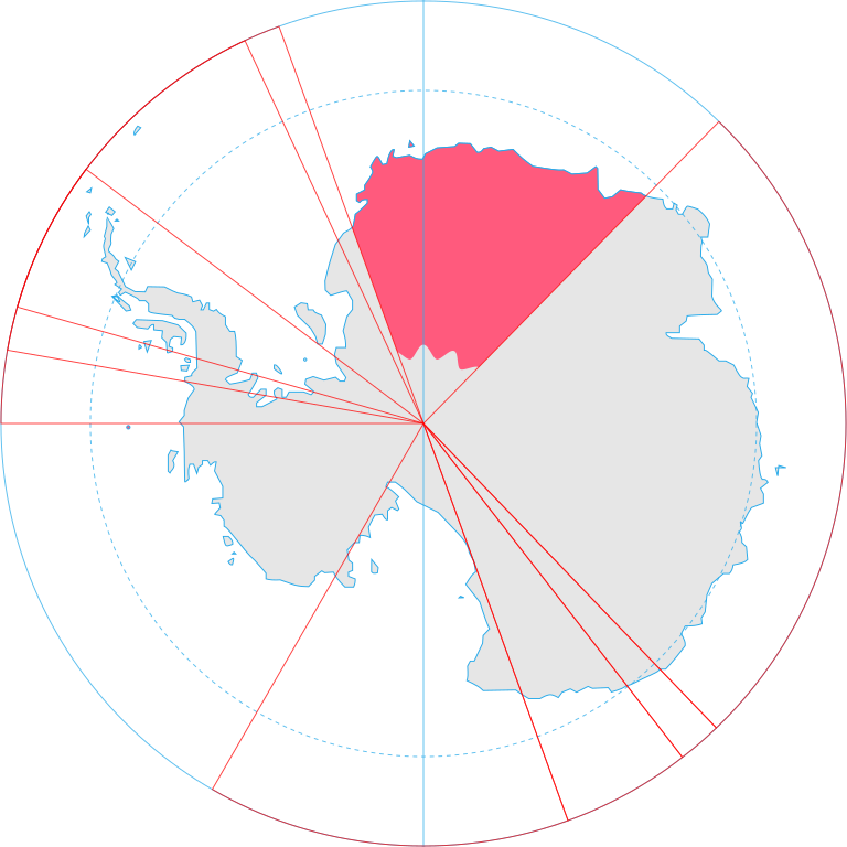
English: Map showing the territorial claim to Antarctica by the country in the filename. Also on the map are is the 60° S Parallel, Antarctic Circle, 0/180 latitude line and (in red) the borders of the claims by other states. |
| תאריך יצירה | |
| מקור | Generated from Antarctica by Lokal_Profil. |
| יוצר | Lokal_Profil |
| אישורים והיתרים (שימוש חוזר בקובץ זה) |
הקובץ הזה מתפרסם לפי תנאי רישיון קריאייטיב קומונז ייחוס-שיתוף זהה 2.5 כללי. ייחוס: Lokal_Profil
|
היסטוריית הקובץ
ניתן ללחוץ על תאריך/שעה כדי לראות את הקובץ כפי שנראה באותו זמן.
| תאריך/שעה | תמונה ממוזערת | ממדים | משתמש | הערה | |
|---|---|---|---|---|---|
| נוכחית | 23:55, 30 ביוני 2008 | | 806 × 806 (65 ק"ב) | Lokal Profil | {{Information |Description={{en|Map showing the territorial claim to Antarctica by the country in the filename. Also on the map are is the 60° S Parallel, Antarctic Circle, 0/180 latitude line and (in red) the borders of the claims by other states.}} |So |
שימוש בקובץ
![]() אין בוויקיפדיה דפים המשתמשים בקובץ זה.
אין בוויקיפדיה דפים המשתמשים בקובץ זה.
שימוש גלובלי בקובץ
אתרי הוויקי השונים הבאים משתמשים בקובץ זה:
- שימוש באתר af.wikipedia.org
- שימוש באתר ar.wikipedia.org
- שימוש באתר bn.wikipedia.org
- שימוש באתר br.wikipedia.org
- שימוש באתר ca.wikipedia.org
- שימוש באתר chr.wikipedia.org
- שימוש באתר da.wikipedia.org
- שימוש באתר diq.wikipedia.org
- שימוש באתר el.wikipedia.org
- שימוש באתר en.wikipedia.org
- שימוש באתר eo.wikipedia.org
- שימוש באתר et.wikipedia.org
- שימוש באתר eu.wikipedia.org
- שימוש באתר fa.wikipedia.org
- שימוש באתר fi.wikipedia.org
- שימוש באתר frr.wikipedia.org
- שימוש באתר fr.wikipedia.org
- שימוש באתר gl.wikipedia.org
- שימוש באתר gv.wikipedia.org
- שימוש באתר hu.wikipedia.org
- שימוש באתר id.wikipedia.org
- שימוש באתר ilo.wikipedia.org
- שימוש באתר it.wikipedia.org
- שימוש באתר ja.wikipedia.org
- שימוש באתר ka.wikipedia.org
- שימוש באתר kk.wikipedia.org
- שימוש באתר lt.wikipedia.org
- שימוש באתר lv.wikipedia.org
- שימוש באתר mi.wikipedia.org
- שימוש באתר nl.wikipedia.org
- שימוש באתר nn.wikipedia.org
- שימוש באתר no.wikipedia.org
- שימוש באתר pl.wikipedia.org