
קובץ:Bay Bridge collapse 2.jpg
אין גרסה ברזולוציה גבוהה יותר.
Bay_Bridge_collapse_2.jpg (341 × 276 פיקסלים, גודל הקובץ: 12 ק"ב, סוג MIME: image/jpeg)
| זהו קובץ שמקורו במיזם ויקישיתוף. תיאורו בדף תיאור הקובץ המקורי (בעברית) מוצג למטה. |
תקציר
| תיאור |
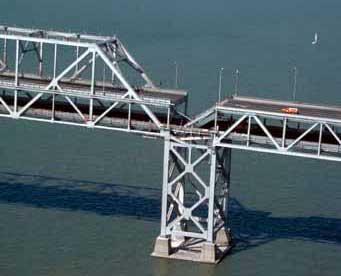
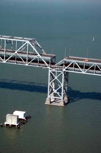
English: Aerial view of roadbed collapse near the interface of the cantil�T truss sections of the San Francisco-Oakland Bay Bridge. View northwestward. Cropped from original version to better fit en:San Francisco–Oakland Bay Bridge article. |
| תאריך יצירה | צולם ב־ אוקטובר 1989 |
| מקור |
USGS |
| יוצר | C.E. Meyer |
| אישורים והיתרים (שימוש חוזר בקובץ זה) |
PD-USGov-Interior-USGS |
| גרסאות אחרות |
|


רישיון
This image is in the public domain in the United States because it only contains materials that originally came from the United States Geological Survey, an agency of the United States Department of the Interior. For more information, see the official USGS copyright policy.
|
Wikipedia upload log
A Wikipedia description page is/was here. All following user names refer to en.wikipedia.
- 2007-09-04 19:13 Paul.h 341×276×8 (12116 bytes) [http://wrgis.wr.usgs.gov/dds/dds-29/ USGS photo] from 1989 Loma Prieta earthquake. '''Caption''': Aerial view of roadbed collapse near the interface of the cantil�T truss sections of the San Francisco-Oakland Bay Bridge. View northwestward. [C.E. Meyer
היסטוריית הקובץ
ניתן ללחוץ על תאריך/שעה כדי לראות את הקובץ כפי שנראה באותו זמן.
| תאריך/שעה | תמונה ממוזערת | ממדים | משתמש | הערה | |
|---|---|---|---|---|---|
| נוכחית | 09:06, 6 ביולי 2008 | | 276 × 341 (12 ק"ב) | Optigan13 | {{Information |Description={{en|Aerial view of roadbed collapse near the interface of the cantil�T truss sections of the San Francisco-Oakland Bay Bridge. View northwestward. Cropped from original version to better fit [[:en:San Francisco–Oakland Bay |
שימוש בקובץ
הדף הבא משתמש בקובץ הזה:
שימוש גלובלי בקובץ
אתרי הוויקי השונים הבאים משתמשים בקובץ זה:
- שימוש באתר en.wikipedia.org
- שימוש באתר pl.wikipedia.org
- שימוש באתר sl.wikipedia.org
- שימוש באתר th.wikipedia.org
- שימוש באתר tr.wikipedia.org
- שימוש באתר zh.wikipedia.org