
קובץ:Carte de la Guyane françoise et l'isle de Cayenne (Bellin, 1763).jpg

גודל התצוגה המקדימה הזאת: 800 × 595 פיקסלים. רזולוציות אחרות: 320 × 238 פיקסלים | 640 × 476 פיקסלים | 1,024 × 762 פיקסלים | 1,267 × 943 פיקסלים.
לקובץ המקורי (1,267 × 943 פיקסלים, גודל הקובץ: 1.08 מ"ב, סוג MIME: image/jpeg)
| זהו קובץ שמקורו במיזם ויקישיתוף. תיאורו בדף תיאור הקובץ המקורי (בעברית) מוצג למטה. |
.jpg)
.jpg?uselang=he)
תקציר
| תיאור |
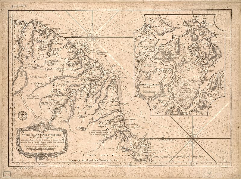
English: This map of French Guiana and the island of Cayenne was made in 1763 by Jacques Bellin (1703-72), a prolific cartographer assigned the Ministry of the French Navy.
Français : Carte de la Guyane françoise et l'isle de Cayenne
Cette carte de la Guyane française et l'île de Cayenne est due à Jacques Bellin (1703-72), un cartographe prolifique affecté au ministère de la Marine française. Elle reflète le soin apporté aux relevés topographiques des baies, des mers et des ports qui caractérisait la cartographie navale française du XVIIIe siècle. En plus d'informations détaillées sur la côte, la carte de Bellin inclut des notes sur l'intérieur de cette partie de l'Amérique du sud, dont l'essentiel restait encore largement inconnu des Européens. |
|||||||||||||||||||
| תאריך יצירה | , Versailles, France | |||||||||||||||||||
| מקור | Bibliothèque numérique mondiale | |||||||||||||||||||
| יוצר |
|
|||||||||||||||||||
רישיון
|
יצירה זו נמצאת בנחלת הכלל במדינת המקור ובמדינות אחרות בהם תקופת זכויות היוצרים היא משך חיי היוצר ו-100 שנה (או פחות) מפטירתו.
| |
| הקובץ הזה זוהה כקובץ חופשי מכל מגבלה ידועה תחת חוק זכויות היוצרים, כולל כל הזכויות הקשורות והסמוכות. | |
היסטוריית הקובץ
ניתן ללחוץ על תאריך/שעה כדי לראות את הקובץ כפי שנראה באותו זמן.
| תאריך/שעה | תמונה ממוזערת | ממדים | משתמש | הערה | |
|---|---|---|---|---|---|
| נוכחית | 02:51, 22 באפריל 2009 | | 943 × 1,267 (1.08 מ"ב) | Abalg | {{Information |Description={{en|1=This map of French Guiana and the island of Cayenne was made in 1763 by Jacques Bellin (1703-72), a prolific cartographer assigned the Ministry of the French Navy.}} {{fr|1=Carte de la Guyane françoise et l'isle de Cayen |
שימוש בקובץ
הדף הבא משתמש בקובץ הזה:
שימוש גלובלי בקובץ
אתרי הוויקי השונים הבאים משתמשים בקובץ זה:
- שימוש באתר af.wikipedia.org
- שימוש באתר ar.wikipedia.org
- שימוש באתר bn.wikipedia.org
- שימוש באתר br.wikipedia.org
- שימוש באתר en.wikipedia.org
- שימוש באתר es.wikipedia.org
- שימוש באתר fr.wikipedia.org
- שימוש באתר gcr.wikipedia.org
- שימוש באתר it.wikipedia.org
- שימוש באתר pt.wikipedia.org
- שימוש באתר ru.wikipedia.org
- שימוש באתר sr.wikipedia.org
- שימוש באתר vi.wikipedia.org
- שימוש באתר www.wikidata.org
.jpg)