
קובץ:CastelloPlanOriginal.jpg
גודל התצוגה המקדימה הזאת: 800 × 533 פיקסלים. רזולוציות אחרות: 320 × 213 פיקסלים | 640 × 426 פיקסלים | 1,024 × 682 פיקסלים | 1,280 × 852 פיקסלים | 2,100 × 1,398 פיקסלים.
לקובץ המקורי (2,100 × 1,398 פיקסלים, גודל הקובץ: 3.28 מ"ב, סוג MIME: image/jpeg)
| זהו קובץ שמקורו במיזם ויקישיתוף. תיאורו בדף תיאור הקובץ המקורי (בעברית) מוצג למטה. |
תקציר
| תיאור |
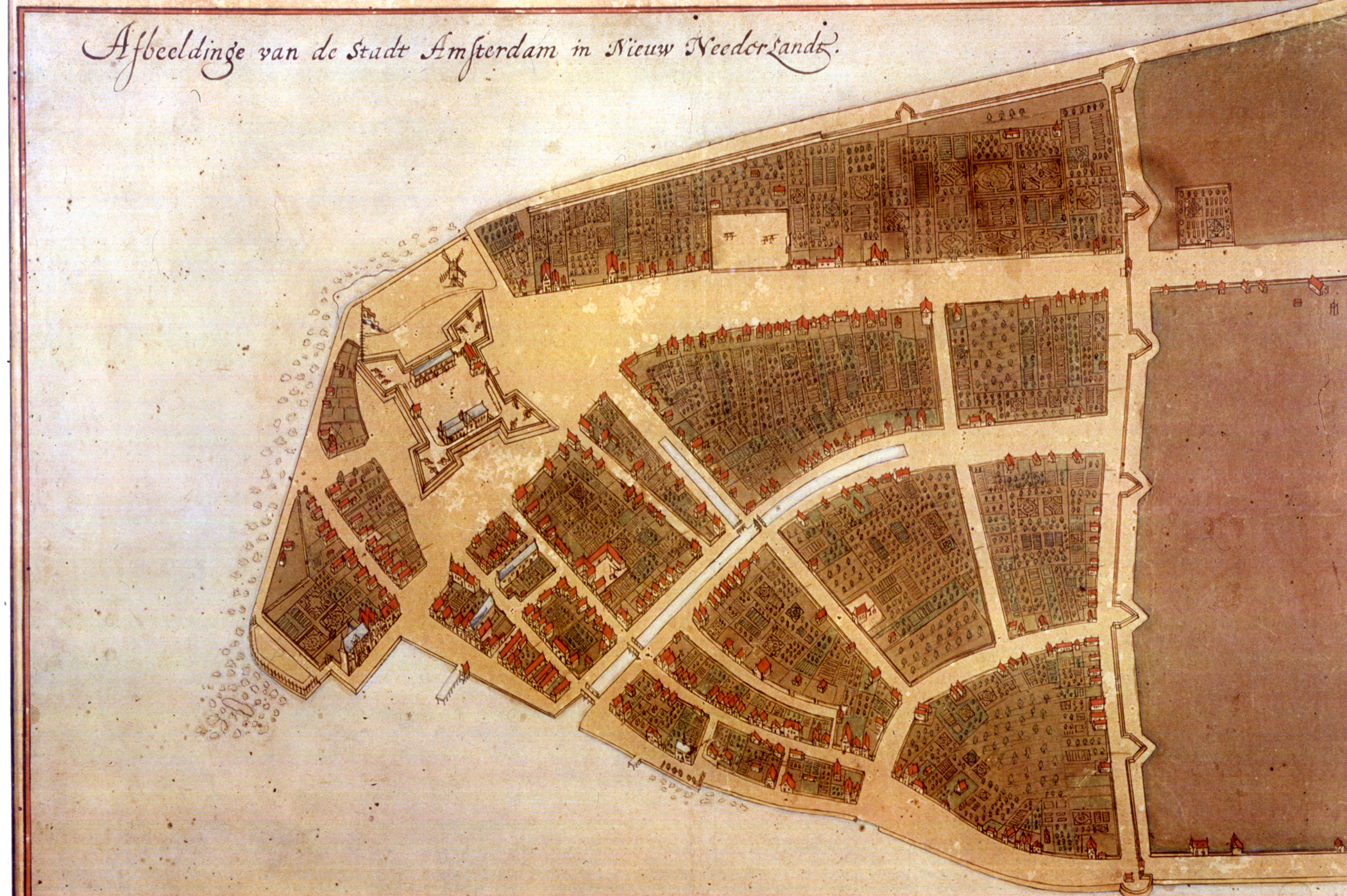
The original en:Castello Plan. Full size photograph of manuscript map in the Biblioteca Medicea-Laurenziana of Florence, Italy. The Castello plan is the earliest known plan of New Amsterdam (not Amsterdam, as you can see on the picture), and the only one dating from the Dutch period. The text at the top of the image states: "Image of the city Amsterdam in New Netherland". |
| תאריך יצירה | |
| מקור | New York Public Library, Digital Gallery. Digital ID: 54682, Digital Record ID: 118555. |
| יוצר | Jacques Cortelyou, General Governor of Nieuw Amsterdam at that time. |
| גרסאות אחרות |
_Castello_Plan_1660.jpg)  |
רישיון
|
עבודת אמנות דו-מימדית זו המוצגת בתמונה שוחררה לרשות הציבור בכל העולם בעקבות תאריך מותו של היוצר, או תאריך פרסום היצירה. לפיכך, תצלום היצירה גם הוא ברשות הציבור.
הודעה זו תקפה לגבי התצלומים שנוצרו בארצות הברית, בגרמניה ובמדינות רבות נוספות.
| ||||
| This image is available from the New York Public Library's Digital Library under the strucID 118555 This tag does not indicate the copyright status of the attached work. A normal copyright tag is still required. See Commons:Licensing for more information. |
.
היסטוריית הקובץ
ניתן ללחוץ על תאריך/שעה כדי לראות את הקובץ כפי שנראה באותו זמן.
| תאריך/שעה | תמונה ממוזערת | ממדים | משתמש | הערה | |
|---|---|---|---|---|---|
| נוכחית | 00:16, 26 באפריל 2012 | | 1,398 × 2,100 (3.28 מ"ב) | Fentener van Vlissingen | higher resolution |
| 20:05, 9 ביולי 2010 |  | 905 × 1,200 (180 ק"ב) | JuTa | higher resolution from de:Datei:Manhattan1.jpg uploaded by de:user:Nikater at 2006-07-13 14:31:26 local time | |
| 02:07, 13 באוקטובר 2007 |  | 569 × 760 (355 ק"ב) | Hu Totya | {{Information |Description=The original en:Castello plan. Full size photograph of manuscript map in the Biblioteca Medicea-Laurenziana of Florence, Italy. The Castello plan is the earliest known plan of New Amsterdam, and the only one dating from the |
שימוש בקובץ
![]() אין בוויקיפדיה דפים המשתמשים בקובץ זה.
אין בוויקיפדיה דפים המשתמשים בקובץ זה.
שימוש גלובלי בקובץ
אתרי הוויקי השונים הבאים משתמשים בקובץ זה:
- שימוש באתר ar.wikipedia.org
- שימוש באתר arz.wikipedia.org
- שימוש באתר azb.wikipedia.org
- שימוש באתר cdo.wikipedia.org
- שימוש באתר en.wikipedia.org
- שימוש באתר fa.wikipedia.org