
קובץ:Central-Eastern-Livingston-Map.png
גודל התצוגה המקדימה הזאת: 798 × 600 פיקסלים. רזולוציות אחרות: 320 × 240 פיקסלים | 639 × 480 פיקסלים | 1,022 × 768 פיקסלים | 1,280 × 962 פיקסלים | 2,560 × 1,924 פיקסלים | 3,928 × 2,952 פיקסלים.
לקובץ המקורי (3,928 × 2,952 פיקסלים, גודל הקובץ: 3.08 מ"ב, סוג MIME: image/png)
| זהו קובץ שמקורו במיזם ויקישיתוף. תיאורו בדף תיאור הקובץ המקורי (בעברית) מוצג למטה. |
תקציר
| תיאור |
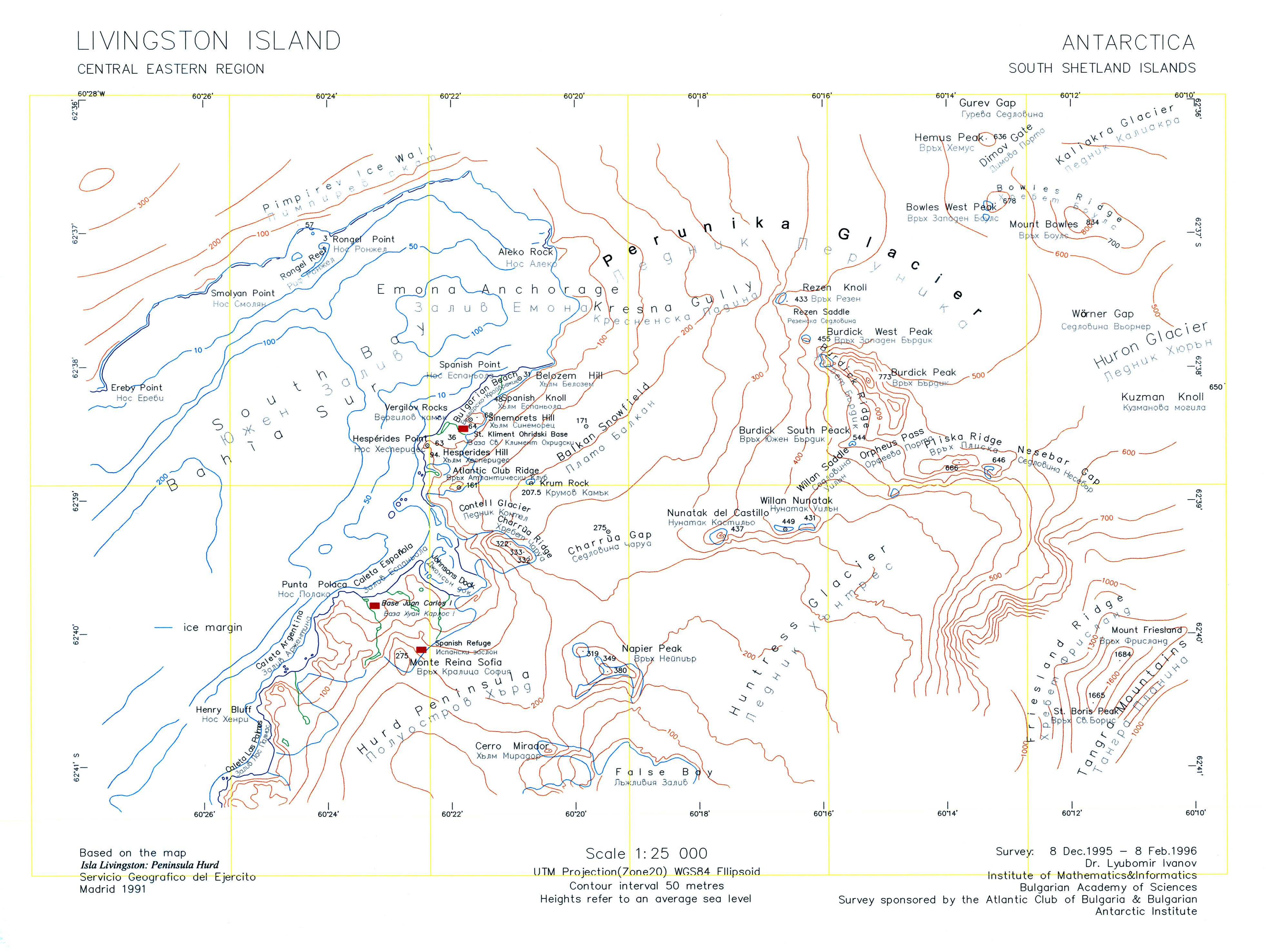
English: A version of the original 1996 map "L.L. Ivanov. Livingston Island: Central-Eastern Region. Scale 1:25000 topographic map. Sofia: Antarctic Place-names Commission of Bulgaria, 1996." uploaded by the author of that map who is also the CEO of the Antarctic Place-names Commission. |
| תאריך יצירה | |
| מקור | נוצר על־ידי מעלה היצירה |
| יוצר | Apcbg |
| גרסאות אחרות | File:Central-Eastern-Livingston-Map-1996.png |
רישיון
אני, בעל זכויות היוצרים על היצירה הזאת, מפרסם אותה בזאת תחת הרישיונות הבאים:
הקובץ הזה מתפרסם לפי תנאי רישיון קריאייטיב קומונז ייחוס-שיתוף זהה 3.0 לא מותאם.
- הנכם רשאים:
- לשתף – להעתיק, להפיץ ולהעביר את העבודה
- לערבב בין עבודות – להתאים את העבודה
- תחת התנאים הבאים:
- ייחוס – יש לתת ייחוס הולם, לתת קישור לרישיון, ולציין אם נעשו שינויים. אפשר לעשות את זה בכל צורה סבירה, אבל לא בשום צורה שמשתמע ממנה שמעניק הרישיון תומך בך או בשימוש שלך.
- שיתוף זהה – אם תיצרו רמיקס, תשנו, או תבנו על החומר, חובה עליכם להפיץ את התרומות שלך לפי תנאי רישיון זהה או תואם למקור.

|
מוענקת בכך הרשות להעתיק, להפיץ או לשנות את המסמך הזה, לפי תנאי הרישיון לשימוש חופשי במסמכים של גנו, גרסה 1.2 או כל גרסה מאוחרת יותר שתפורסם על־ידי המוסד לתוכנה חופשית; ללא פרקים קבועים, ללא טקסט עטיפה קדמית וללא טקסט עטיפה אחורית. עותק של הרישיון כלול בפרק שכותרתו הרישיון לשימוש חופשי במסמכים של גנו. |
הנכם מוזמנים לבחור את הרישיון הרצוי בעיניכם.
היסטוריית הקובץ
ניתן ללחוץ על תאריך/שעה כדי לראות את הקובץ כפי שנראה באותו זמן.
| תאריך/שעה | תמונה ממוזערת | ממדים | משתמש | הערה | |
|---|---|---|---|---|---|
| נוכחית | 13:45, 27 ביולי 2010 | | 2,952 × 3,928 (3.08 מ"ב) | Apcbg | Minor fixes. |
| 11:47, 27 ביולי 2010 |  | 2,952 × 3,928 (33.23 מ"ב) | Apcbg | {{Information |Description={{en|1=A version of the original 1996 map ''L.L. Ivanov. Livingston Island: Central-Eastern Region. Scale 1:25000 topographic map. Sofia: Antarctic Place-names Commission of Bulgaria, 1996.'' uploaded by the author of that map. |
שימוש בקובץ
הדפים הבאים משתמשים בקובץ הזה:
שימוש גלובלי בקובץ
אתרי הוויקי השונים הבאים משתמשים בקובץ זה:
- שימוש באתר ar.wikipedia.org
- שימוש באתר bg.wikipedia.org
- שימוש באתר en.wikipedia.org
- Aleko Point
- Atlantic Club Ridge
- Bowles West Peak
- Bulgarian Beach
- Charrúa Gap
- Dimov Gate
- Emona Anchorage
- Gurev Gap
- Hesperides Hill
- Kresna Gully
- Krum Rock
- Rezen Knoll
- Rezen Saddle
- Rongel Point
- Rongel Reef
- Sea Lion Glacier
- Sea Lion Tarn
- Sinemorets Hill
- Smolyan Point
- Spanish Knoll
- Spanish Point (Antarctica)
- St. Boris Peak
- Vergilov Rocks
- Willan Saddle
- Balkan Snowfield
- Belozem Hill
- Mount Friesland
- Willan Nunatak
- Contell Glacier
- Pimpirev Ice Wall
- שימוש באתר it.wikipedia.org
- שימוש באתר nl.wikipedia.org
- שימוש באתר pt.wikipedia.org
- שימוש באתר uk.wikipedia.org