
קובץ:Corrientes-oceanicas-en.svg

גודל התצוגה המקדימה הזאת מסוג PNG של קובץ ה־SVG הזה: 800 × 404 פיקסלים. רזולוציות אחרות: 320 × 162 פיקסלים | 640 × 323 פיקסלים | 1,024 × 517 פיקסלים | 1,280 × 647 פיקסלים | 2,560 × 1,293 פיקסלים | 976 × 493 פיקסלים.
לקובץ המקורי (קובץ SVG, הגודל המקורי: 976 × 493 פיקסלים, גודל הקובץ: 1.63 מ"ב)
| זהו קובץ שמקורו במיזם ויקישיתוף. תיאורו בדף תיאור הקובץ המקורי (בעברית) מוצג למטה. |
תקציר
| תיאור |
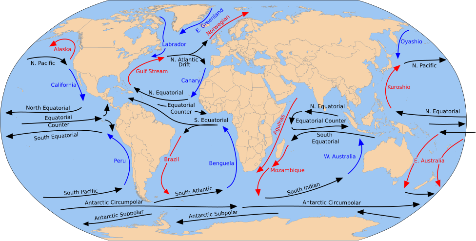
English: A detailed Robinson-projection SVG map with grouping enabled to connect all non-contiguous parts of a country's territory for easy colouring. Smaller countries can also be represented by larger circles to show their data easier. A thorough description of use and other instructions relating to can be found on the instruction page. |
| תאריך יצירה | (UTC) |
| מקור |
קובץ זה הוא יצירה נגזרת של: Blank map of the world (Robinson projection) (10E).svg: קובץ זה הוא יצירה נגזרת של: Corrientes-oceanicas.png: |
| יוצר |
|
_(10E).svg)

|
SVG עושה שימוש בטקסט שניתן לתרגם בקלות לשפתך. לפרטים נוספים. עבור תמונות SVG, ניתן להשתמש ב[toolforge:svgtranslate/File:Corrientes-oceanicas-en.svglink כלי עזר] כדי לתרגם את התמונה לשפתך. |
. Inkscape עם נוצרה ה תמונה
רישיון
אני, בעל זכויות היוצרים על עבודה זו, מפרסם בזאת את העבודה תחת הרישיון הבא:
| ברצוני, בעלי זכויות היוצרים על יצירה זו, לשחרר יצירה זו לנחלת הכלל. זה תקף בכל העולם. יש מדינות שבהן הדבר אינו אפשרי על פי חוק, אם כך: אני מעניק לכל אחד את הזכות להשתמש בעבודה זו לכל מטרה שהיא, ללא תנאים כלשהם, אלא אם כן תנאים כאלה נדרשים על פי חוק. |
יומן העלאה מקורי
This image is a derivative work of the following images:
- File:Blank map of the world (Robinson projection) (10E).svg licensed with PD-self
- 2011-05-16T04:18:31Z Milenioscuro 3100x1600 (2087786 Bytes) {{Information |Description={{en|1=A detailed Robinson-projection [[Help:SVG|SVG]] map with grouping enabled to connect all non-contiguous parts of a country's territory for easy colouring. Smaller countries can also be repres
Uploaded with derivativeFX
היסטוריית הקובץ
ניתן ללחוץ על תאריך/שעה כדי לראות את הקובץ כפי שנראה באותו זמן.
| תאריך/שעה | תמונה ממוזערת | ממדים | משתמש | הערה | |
|---|---|---|---|---|---|
| נוכחית | 20:43, 30 ביולי 2023 | | 493 × 976 (1.63 מ"ב) | Matěj Grabovský | File uploaded using svgtranslate tool (https://svgtranslate.toolforge.org/). Added translation for cs. |
| 21:08, 15 בדצמבר 2014 |  | 493 × 976 (1.67 מ"ב) | RicHard-59 | Guls -> Gulf | |
| 17:20, 28 באפריל 2014 |  | 493 × 976 (1.58 מ"ב) | Moja~commonswiki | Correct "Oyashia" -> "Oyashio" | |
| 17:51, 17 באוגוסט 2012 |  | 493 × 976 (1.66 מ"ב) | Popadius | Reverted to version as of 14:42, 17 August 2012 | |
| 17:49, 17 באוגוסט 2012 |  | 493 × 976 (1.1 מ"ב) | Popadius | small fix | |
| 17:42, 17 באוגוסט 2012 |  | 493 × 976 (1.66 מ"ב) | Popadius | == {{int:filedesc}} == {{Information |Description={{en|1=A detailed Robinson-projection SVG map with grouping enabled to connect all non-contiguous parts of a country's territory for easy colouring. Smaller countries can also be represente... |
שימוש בקובץ
הדף הבא משתמש בקובץ הזה:
שימוש גלובלי בקובץ
אתרי הוויקי השונים הבאים משתמשים בקובץ זה:
- שימוש באתר ca.wikipedia.org
- שימוש באתר cs.wikipedia.org
- שימוש באתר de.wikipedia.org
- שימוש באתר en.wikipedia.org
- שימוש באתר eo.wikipedia.org
- שימוש באתר es.wikipedia.org
- שימוש באתר eu.wikipedia.org
- Ozeano Australa
- Golkoko itsaslasterra
- Humboldt itsaslasterra
- Agulhasko itsaslasterra
- Alaskako itsaslasterra
- Itsaslaster Zirkunpolar Antartikoa
- Antilletako itsaslasterra
- Benguelako itsaslasterra
- Brasilgo itsaslasterra
- Kaliforniako itsaslasterra
- Kanarietako itsaslasterra
- Floridako itsaslasterra
- Azoreetako itsaslasterra
- Karibeko itsaslasterra
- Cromwell itsaslasterra
- Ekialdeko Australiako itsaslasterra
- Groenlandiako ekialdeko itsaslasterra
- Madagaskarko ekialdeko itsaslasterra
- Malvinetako itsaslasterra
- Gineako itsaslasterra
- Irminger itsaslasterra
- Kuroshio itsaslasterra
- Oyashio itsaslasterra
- Labradorko itsaslasterra
- Leeuwingo itsaslasterra
- Lomonosov itsaslasterra
- Madagaskarko itsaslasterra
- Mindanaoko itsaslasterra
- Mozambikeko itsaslasterra
- Ipar Atlantikoko itsaslasterra
- Iparraldeko itsaslaster ekuatoriala
- Kontralaster Ekuatoriala
- Ipar Pazifikoko itsaslasterra
- Norvegiako itsaslasterra
- Portugalgo itsaslasterra