
קובץ:Deepwater Horizon oil spill - May 24, 2010.jpg

לקובץ המקורי (2,118 × 1,628 פיקסלים, גודל הקובץ: 369 ק"ב, סוג MIME: image/jpeg)
| זהו קובץ שמקורו במיזם ויקישיתוף. תיאורו בדף תיאור הקובץ המקורי (בעברית) מוצג למטה. |
תקציר
| תיאור |
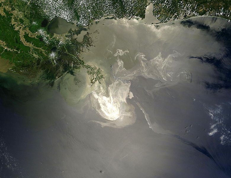
English: Description from NASA (source):
"NASA's Terra Satellites Sees Spill on May 24
Français : Traduction partielle de la description par la NASA(source): La marée noire causée par l'incendie de la plateforme pétrolière Deepwater Horizon vue par le satellite Terra, de la NASA, le 24 mai 2010.
Cette image a été acquise par le Moderate-Resolution Imaging Spectroradiometer (MODIS, pour Spectroradiomètre d'imagerie à résolution moyenne), embarqué sur le satellite Terra. Le pétrole lisse la surface de l'océan, ce qui la rend plus claire là où elle réfléchit le soleil (par exemple, au centre de la photo) et plus sombre ailleurs (par exemple en bas à droite). Le delta du Mississippi est visible en haut, entouré d'eaux saumâtres et boueuses qui apparaissent en brun, rayé de rubans argentés de pétrole. |
| תאריך יצירה | |
| מקור | Original image, here cropped on left and at top |
| יוצר | NASA/GSFC, MODIS Rapid Response |
| גרסאות אחרות |
|

|

רישיון
| קובץ זה נמצא ברשות הציבור מכיוון שהוא נוצר על ידי נאס"א. מדיניות זכויות היוצרים של נאס"א קובעת ש"חומרים של NASA אינם מוגנים בזכויות יוצרים אלא אם צוין אחרת". (דף מדיניות זכויות היוצרים ב-NASA או מדיניות שימוש בתמונות ב-JPL). | ||
 |
אזהרות:
|
היסטוריית הקובץ
ניתן ללחוץ על תאריך/שעה כדי לראות את הקובץ כפי שנראה באותו זמן.
| תאריך/שעה | תמונה ממוזערת | ממדים | משתמש | הערה | |
|---|---|---|---|---|---|
| נוכחית | 08:26, 26 במאי 2010 | | 1,628 × 2,118 (369 ק"ב) | APK | == Summary == {{Information |Description={{en|"Sunlight illuminated the lingering oil slick off the Mississippi Delta on May 24, 2010. The Moderate Resolution Imaging Spectroradiometer (MODIS) on NASA’s Terra satellit |
שימוש בקובץ
הדף הבא משתמש בקובץ הזה:
שימוש גלובלי בקובץ
אתרי הוויקי השונים הבאים משתמשים בקובץ זה:
- שימוש באתר af.wikipedia.org
- שימוש באתר be.wikipedia.org
- שימוש באתר ca.wikipedia.org
- שימוש באתר cs.wikipedia.org
- שימוש באתר da.wikipedia.org
- שימוש באתר de.wikipedia.org
- שימוש באתר el.wikipedia.org
- שימוש באתר en.wikipedia.org
- Marine conservation
- Portal:Marine life
- Wikipedia:Featured pictures/Space/Looking back
- Wikipedia:Featured picture candidates/delist/2010
- Wikipedia:Featured pictures thumbs/23
- Wikipedia:Featured picture candidates/June-2010
- Wikipedia:ITN archives/2010/May
- Talk:Deepwater Horizon oil spill/Archive 4
- Wikipedia:Featured picture candidates/Deepwater Horizon oil spill - May 24, 2010.jpg
- Wikipedia:Wikipedia Signpost/2010-06-28/Features and admins
- User talk:APK/Archive 22
- Wikipedia:Featured picture candidates/delist/Deepwater oil spill 5-24-10
- Talk:Deepwater Horizon oil spill/Archive 10
- Wikipedia:Picture of the day/April 2012
- Template:POTD/2012-04-20
- Wikipedia:Main Page history/2012 April 20
- User talk:APK/Archive 25
- Research and Development Institute of Ecology and the Sustainable Use of Natural Resources
- Wikipedia:Wikipedia Signpost/Single/2010-06-28
- Flash-gas (petroleum)
- שימוש באתר en.wikinews.org
- שימוש באתר et.wikipedia.org
- שימוש באתר fa.wikipedia.org
- שימוש באתר fr.wikibooks.org
- שימוש באתר hr.wikipedia.org
- שימוש באתר hu.wikinews.org
- שימוש באתר hy.wikipedia.org
- שימוש באתר lv.wikipedia.org
- שימוש באתר ms.wikipedia.org
- שימוש באתר nl.wikipedia.org