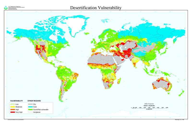
קובץ:Desertification map.png

גודל התצוגה המקדימה הזאת: 800 × 518 פיקסלים. רזולוציות אחרות: 320 × 207 פיקסלים | 640 × 414 פיקסלים | 1,024 × 663 פיקסלים | 1,280 × 828 פיקסלים | 2,560 × 1,656 פיקסלים | 6,800 × 4,400 פיקסלים.
לקובץ המקורי (6,800 × 4,400 פיקסלים, גודל הקובץ: 1.04 מ"ב, סוג MIME: image/png)
היסטוריית הקובץ
ניתן ללחוץ על תאריך/שעה כדי לראות את הקובץ כפי שנראה באותו זמן.
| תאריך/שעה | תמונה ממוזערת | ממדים | משתמש | הערה | |
|---|---|---|---|---|---|
| נוכחית | 14:01, 27 במרץ 2022 |  | 4,400 × 6,800 (1.04 מ"ב) | No.cilepogača | Reverted to version as of 00:12, 8 November 2006 (UTC) |
| 08:11, 8 בנובמבר 2006 |  | 1,100 × 1,700 (558 ק"ב) | Paleorthid | {{Information |Description=Global Desertification Vulnerability Map |Source=http://soils.usda.gov/use/worldsoils/mapindex/desert-map.zip |Date=1998 |Author=USDA employee |Permission=This image is a work of a United States Department of Agriculture employe | |
| 03:12, 8 בנובמבר 2006 |  | 4,400 × 6,800 (1.04 מ"ב) | Paleorthid | {{Information |Description=Global Desertification Vulnerability Map |Source=http://soils.usda.gov/use/worldsoils/mapindex/desert-map.zip |Date=1998 |Author=USDA employee |Permission=This image is a work of a United States Department of Agriculture employe |
שימוש בקובץ
הדף הבא משתמש בקובץ הזה:
שימוש גלובלי בקובץ
אתרי הוויקי השונים הבאים משתמשים בקובץ זה:
- שימוש באתר ar.wikipedia.org
- שימוש באתר az.wikipedia.org
- שימוש באתר bg.wikipedia.org
- שימוש באתר bn.wikipedia.org
- שימוש באתר bo.wikipedia.org
- שימוש באתר ca.wikinews.org
- שימוש באתר ckb.wikipedia.org
- שימוש באתר cs.wikipedia.org
- שימוש באתר da.wikipedia.org
- שימוש באתר de.wikipedia.org
- שימוש באתר de.wiktionary.org
- שימוש באתר el.wikipedia.org
- שימוש באתר en.wikipedia.org
- שימוש באתר eo.wikipedia.org
- שימוש באתר es.wikipedia.org
- שימוש באתר eu.wikipedia.org
- שימוש באתר fa.wikipedia.org
- שימוש באתר fi.wikipedia.org
- שימוש באתר fr.wikipedia.org
- שימוש באתר fr.wikinews.org
- שימוש באתר ga.wikipedia.org
- שימוש באתר hu.wikipedia.org
- שימוש באתר hy.wikipedia.org
- שימוש באתר id.wikipedia.org
- שימוש באתר is.wikipedia.org
- שימוש באתר it.wikipedia.org
- שימוש באתר ja.wikipedia.org

