קובץ:Fort-Jefferson Dry-Tortugas.jpg

תוכן הדף אינו נתמך בשפות אחרות.
מתוך ויקיפדיה, האנציקלופדיה החופשית

לקובץ המקורי(1,200 × 796 פיקסלים, גודל הקובץ: 1.03 מ"ב, סוג MIME‏: image/jpeg)

ויקישיתוף זהו קובץ שמקורו במיזם ויקישיתוף. תיאורו בדף תיאור הקובץ המקורי (בעברית) מוצג למטה.

This is an image of a place or building that is listed on the National Register of Historic Places in the United States of America. Its reference number is 70000069.

ויקיפדיה

 This is a featured picture on the אנגלית language Wikipedia (Featured pictures) and is considered one of the finest images.

אם לדעתכם ראוי שקובץ זה יהיה מומלץ גם בוויקישיתוף, הרגישו חופשיים להציע אותו.

אם יש ברשותכם תמונה עם איכות דומה שניתן לפרסמה תחת רישיון זכויות יוצרים מתאים, אנא העלו אותה, תייגו אותה, והציעו אותה להמלצה.

תקציר

תיאור

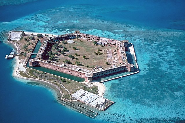
Fort Jefferson at the Dry Tortugas. The clear waters in shallow areas surrounding the fort, seen easily in the photo, are popular for snorkeling and scuba diving. Visible on the right side of the image is a breach of the sea wall caused by the direct strike of Hurricane Charley in August 2004.

מיקום המצלמה24° 37′ 55″ N, 82° 52′ 03″ W  Heading=236.25° Kartographer map based on OpenStreetMap.תמונה זו ותמונות נוספות במיקום: OpenStreetMapinfo
תאריך יצירה
מקור U.S. National Park Service [1]; English Wikipedia, original upload 2 March 2005 by Brian0918
יוצר U.S. National Park Service

רישיון

Public domain This image or media file contains material based on a work of a National Park Service employee, created as part of that person's official duties. As a work of the U.S. federal government, such work is in the public domain in the United States. See the NPS website and NPS copyright policy for more information.


Desktop wallpaper icon
This English Wikipedia featured picture is fairly large and has an aspect ratio of approximately 8:5 or 16:9, making it suitable as a widescreen computer wallpaper.

See the gallery of such images, or the gallery of non-widescreen images.

כיתובים

נא להוסיף משפט שמסביר מה הקובץ מייצג
Fort Jefferson (Florida)

פריטים שמוצגים בקובץ הזה

מוצג

24°37'54.998"N, 82°52'3.000"W

אזימוט: 236.25 מעלה

היסטוריית הקובץ

ניתן ללחוץ על תאריך/שעה כדי לראות את הקובץ כפי שנראה באותו זמן.

תאריך/שעהתמונה ממוזערתממדיםמשתמשהערה
נוכחית18:07, 22 באפריל 2017תמונה ממוזערת לגרסה מ־18:07, 22 באפריל 2017‪796 × 1,200‬ (1.03 מ"ב)Bubba73Color correction and remove some haze
20:57, 8 בדצמבר 2006תמונה ממוזערת לגרסה מ־20:57, 8 בדצמבר 2006‪796 × 1,200‬ (1.01 מ"ב)Holly ChengReverted to earlier revision
08:40, 8 בדצמבר 2006תמונה ממוזערת לגרסה מ־08:40, 8 בדצמבר 2006‪2,048 × 3,072‬ (4.89 מ"ב)Keeleysam
10:50, 16 בספטמבר 2005תמונה ממוזערת לגרסה מ־10:50, 16 בספטמבר 2005‪796 × 1,200‬ (1.01 מ"ב)Saperaud~commonswikiFort Jefferson at the Dry Tortugas. As seen easily in the photo, the clear waters in shallow areas surrounding the fort are popular for snorkeling and SCUBA. Visible on the right side of the image is a breach of the sea wall caused by the direct strik

שימוש גלובלי בקובץ

אתרי הוויקי השונים הבאים משתמשים בקובץ זה:

צפו בשימושים בקובץ זה במיזמי ויקימדיה נוספים.

מטא־נתונים