
קובץ:GolanHights-UNDOF.jpg

גודל התצוגה המקדימה הזאת: 488 × 599 פיקסלים. רזולוציות אחרות: 195 × 240 פיקסלים | 391 × 480 פיקסלים | 974 × 1,196 פיקסלים.
לקובץ המקורי (974 × 1,196 פיקסלים, גודל הקובץ: 246 ק"ב, סוג MIME: image/jpeg)
| זהו קובץ שמקורו במיזם ויקישיתוף. תיאורו בדף תיאור הקובץ המקורי (בעברית) מוצג למטה. |
source: http://de.wikipedia.org/wiki/Bild:GolanHights.JPG
תקציר
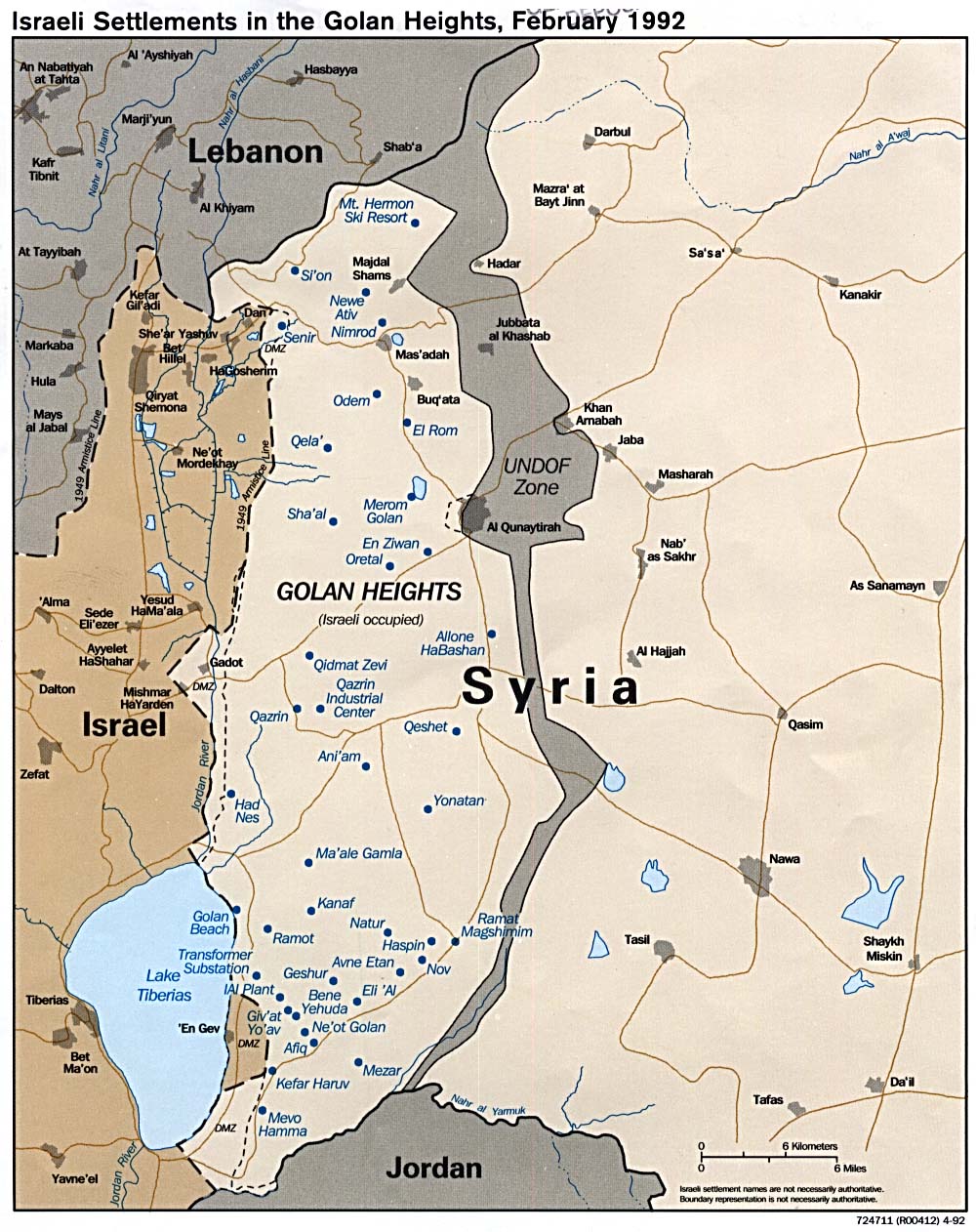
Die Golanhöhen damals und heute, nach den Eroberungen von 1967 und 1973.
Als Basis diente folgende Karte, die sich laut en.wiki unter public domain befindet.
רישיון
אני, בעל זכויות היוצרים על עבודה זו, מפרסם בזאת את העבודה תחת הרישיון הבא:

|
מוענקת בכך הרשות להעתיק, להפיץ או לשנות את המסמך הזה, לפי תנאי הרישיון לשימוש חופשי במסמכים של גנו, גרסה 1.2 או כל גרסה מאוחרת יותר שתפורסם על־ידי המוסד לתוכנה חופשית; ללא פרקים קבועים, ללא טקסט עטיפה קדמית וללא טקסט עטיפה אחורית. עותק של הרישיון כלול בפרק שכותרתו הרישיון לשימוש חופשי במסמכים של גנו. |
| הקובץ הזה מתפרסם לפי תנאי רישיון קריאייטיב קומונז ייחוס-שיתוף זהה 3.0 לא מותאם. | ||
| ||
| תבנית רישוי זו הוספה לקובץ כחלק מעדכון רישיון GFDL. |
22 Jan 2006
de:Benutzer:Hoheit
היסטוריית הקובץ
ניתן ללחוץ על תאריך/שעה כדי לראות את הקובץ כפי שנראה באותו זמן.
| תאריך/שעה | תמונה ממוזערת | ממדים | משתמש | הערה | |
|---|---|---|---|---|---|
| נוכחית | 17:56, 10 במאי 2008 | | 1,196 × 974 (246 ק"ב) | Ori~ | |
| 17:55, 10 במאי 2008 |  | 1,282 × 980 (240 ק"ב) | Ori~ | source: http://de.wikipedia.org/wiki/Bild:GolanHights.JPG == Beschreibung, Quelle == Die Golanhöhen damals und heute, nach den Eroberungen von 1967 und 1973. Als Basis diente folgende [http://www.lib.utexas.edu/maps/middle_east_and_asia/golan_92.jpg Ka |
שימוש בקובץ
הדפים הבאים משתמשים בקובץ הזה:
שימוש גלובלי בקובץ
אתרי הוויקי השונים הבאים משתמשים בקובץ זה:
- שימוש באתר ar.wikipedia.org
- שימוש באתר ca.wikipedia.org
- Resolució 350 del Consell de Seguretat de les Nacions Unides
- Resolució 363 del Consell de Seguretat de les Nacions Unides
- Resolució 557 del Consell de Seguretat de les Nacions Unides
- Resolució 695 del Consell de Seguretat de les Nacions Unides
- Resolució 722 del Consell de Seguretat de les Nacions Unides
- Resolució 996 del Consell de Seguretat de les Nacions Unides
- Resolució 1211 del Consell de Seguretat de les Nacions Unides
- Resolució 1788 del Consell de Seguretat de les Nacions Unides
- Resolució 1994 del Consell de Seguretat de les Nacions Unides
- Resolució 2294 del Consell de Seguretat de les Nacions Unides
- שימוש באתר ckb.wikipedia.org
- שימוש באתר cs.wikipedia.org
- שימוש באתר en.wikipedia.org
- שימוש באתר es.wikipedia.org
- שימוש באתר fa.wikipedia.org
- שימוש באתר id.wikipedia.org
- שימוש באתר mzn.wikipedia.org
- שימוש באתר nl.wikipedia.org
- שימוש באתר tg.wikipedia.org
- שימוש באתר www.wikidata.org