
קובץ:Italy 1000 AD-he.svg

גודל התצוגה המקדימה הזאת מסוג PNG של קובץ ה־SVG הזה: 418 × 600 פיקסלים. רזולוציות אחרות: 167 × 240 פיקסלים | 334 × 480 פיקסלים | 535 × 768 פיקסלים | 713 × 1,024 פיקסלים | 1,427 × 2,048 פיקסלים | 565 × 811 פיקסלים.
לקובץ המקורי (קובץ SVG, הגודל המקורי: 565 × 811 פיקסלים, גודל הקובץ: 481 ק"ב)
| זהו קובץ שמקורו במיזם ויקישיתוף. תיאורו בדף תיאור הקובץ המקורי (בעברית) מוצג למטה. |
| תיאור |
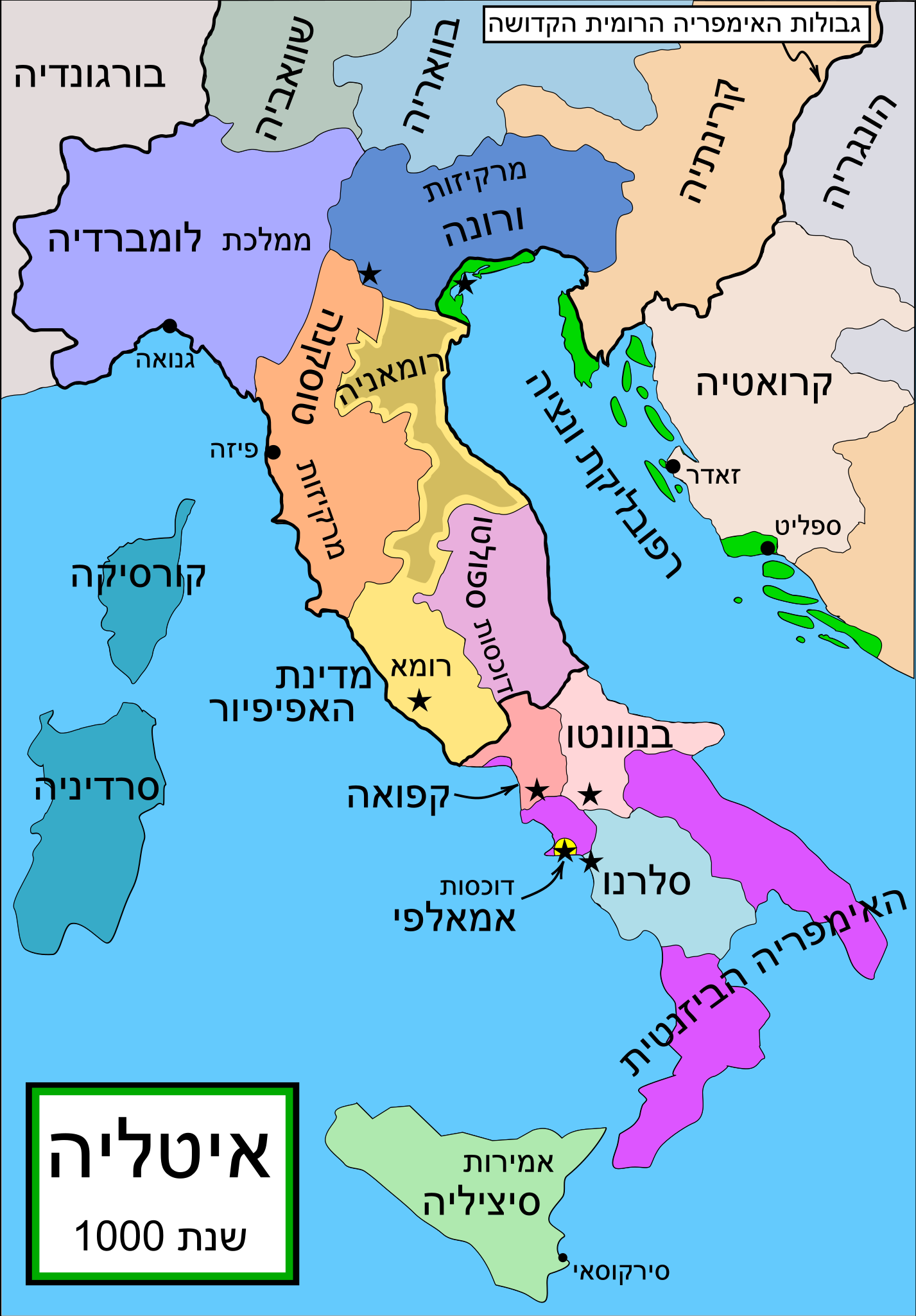
English: Political map of Italy in 1000 AD (CE). Created by MapMaster. |
| תאריך יצירה | (UTC) |
| מקור | |
| יוצר |
|
| גרסאות אחרות |
Part of a series of maps on the history of Italy:
[]
SVG:
PNG:
|


|
SVG עושה שימוש בטקסט שניתן לתרגם בקלות לשפתך. לפרטים נוספים. עבור תמונות SVG, ניתן להשתמש ב[toolforge:svgtranslate/File:Italy_1000_AD-he.svglink כלי עזר] כדי לתרגם את התמונה לשפתך. |
References
- Bjorklund, Oddvar; Holmboe, Haakon; Rohr, Anders (1970) Historical Atlas of the World, Barnes & Noble, NY, SBN: 389-00253-4.
- This map from Allyn & Bacon, Longman, textbook publishers. * This map of the w:en:Holy Roman Empire *A map from Attilios
- This map of 1050 AD Italy, from the 1923 The Historical Atlas by William R. Shepherd
- This map of 1000 AD Italy from Fordham University, adapted from Muir's Historical Atlas, (1911).
In addition, a number of other sources were consulted in an effort to determine the following matters:
- The extent of Venetian control over the cities of Dalmatia such as Zara and Spalato. Although the Venetians had been pushed off the mainland earlier, in the period around the year 1000, the Venetians made an effort to recover these cities.
- The extent of Saracen control over Corsica and Sardinia. Information is sparse. The apparent situation is that the Muslims had several bases on the coasts of these islands, but did not control the countryside (such as they did in Sicily).
- Whether or not the principalities of Capua and Benevento were separate states in the year 1000. Based on lists of their rulers (various Pandulfs and Landulfs), the answer seems to be "yes".
- Who controlled the Balkans on the southeastern border of the Kingdom of Croatia. Candidates include Bulgaria, the Byzantine Empire, Croatia, and Serbia. As noted, there is significant disagreement among sources on these questions.
This map was commissioned by Attilios, and there is also a discussion to be found on MapMaster's English talk page.
| זוהי תמונה מרוטשת, זאת אומרת שהתמונה שונתה בצורה דיגיטלית מהמקור. Modifications: Translated to Hebrew. את התמונה המקורית ניתן לראות ב: Italy 1000 AD.svg. השינוי בוצע על ידי Odedee.
|
אני, בעל זכויות היוצרים על עבודה זו, מפרסם בזאת את העבודה תחת הרישיון הבא:

|
מוענקת בכך הרשות להעתיק, להפיץ או לשנות את המסמך הזה, לפי תנאי הרישיון לשימוש חופשי במסמכים של גנו, גרסה 1.2 או כל גרסה מאוחרת יותר שתפורסם על־ידי המוסד לתוכנה חופשית; ללא פרקים קבועים, ללא טקסט עטיפה קדמית וללא טקסט עטיפה אחורית. עותק של הרישיון כלול בפרק שכותרתו הרישיון לשימוש חופשי במסמכים של גנו. |
| הקובץ הזה מתפרסם לפי תנאי רישיון קריאייטיב קומונז ייחוס-שיתוף זהה 3.0 לא מותאם. | ||
| ||
| תבנית רישוי זו הוספה לקובץ כחלק מעדכון רישיון GFDL. |
יומן העלאה מקורי
This image is a derivative work of the following images:
- File:Italy_1000_AD.svg licensed with GFDL
- 2007-04-17T19:50:51Z MapMaster 565x811 (881823 Bytes) Some further changes
- 2007-02-19T05:10:41Z MapMaster 565x811 (843586 Bytes) changes to ensure consistency with my other Italy maps
- 2006-11-25T05:39:26Z MapMaster 565x811 (842813 Bytes) Improved map.
- 2006-11-18T14:44:51Z MapMaster 565x811 (847000 Bytes) Improved (I hope) version based on recommendations from Attilios.
- 2006-11-17T21:50:24Z MapMaster 565x811 (786867 Bytes) Political map of Italy in 1000 AD (CE).
Uploaded with derivativeFX
היסטוריית הקובץ
ניתן ללחוץ על תאריך/שעה כדי לראות את הקובץ כפי שנראה באותו זמן.
| תאריך/שעה | תמונה ממוזערת | ממדים | משתמש | הערה | |
|---|---|---|---|---|---|
| נוכחית | 02:05, 5 במאי 2009 | | 811 × 565 (481 ק"ב) | Odedee | {{Information |Description='''en:''' Political map of Italy in 1000 AD (CE). Created by MapMaster. Part of a series of maps on the history of Italy: <gallery> Image:Italy and Illyria 1084 v2.svg|1084 AD Image:Italy 1494 v2.png|1494 AD Image:Italy 1796.p |
שימוש בקובץ
הדפים הבאים משתמשים בקובץ הזה: