
קובץ:Karte Cook Seereise nr1.png
גודל התצוגה המקדימה הזאת: 800 × 400 פיקסלים. רזולוציות אחרות: 320 × 160 פיקסלים | 640 × 320 פיקסלים | 1,263 × 632 פיקסלים.
לקובץ המקורי (1,263 × 632 פיקסלים, גודל הקובץ: 97 ק"ב, סוג MIME: image/png)
| זהו קובץ שמקורו במיזם ויקישיתוף. תיאורו בדף תיאור הקובץ המקורי (בעברית) מוצג למטה. |
תקציר
| תיאור |
Deutsch:
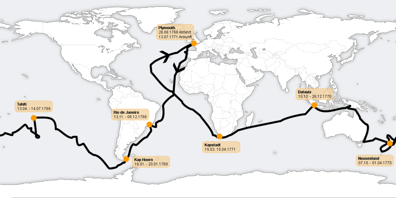
English: The Route of Captain James Cook's first voyage, 1768 -1771. Map labelled in German, so Cape town written as Kapstadt and New Zealand as Neuseeland using current German spelling. Abfahrt is departure, ankunft is arrival.
|
| תאריך יצירה | 2 בספטמבר 2005 (תאריך העלאה מקורי) |
| מקור | הועבר מ- de.wikipedia לוויקישיתוף. |
| יוצר |
מעלה היצירה המקורי היה C.lingg מוויקיפדיה הגרמנית |
רישיון
הקובץ הזה מתפרסם לפי תנאי רישיון קריאייטיב קומונז ייחוס-שיתוף זהה 2.0 גרמניה.
- הנכם רשאים:
- לשתף – להעתיק, להפיץ ולהעביר את העבודה
- לערבב בין עבודות – להתאים את העבודה
- תחת התנאים הבאים:
- ייחוס – יש לתת ייחוס הולם, לתת קישור לרישיון, ולציין אם נעשו שינויים. אפשר לעשות את זה בכל צורה סבירה, אבל לא בשום צורה שמשתמע ממנה שמעניק הרישיון תומך בך או בשימוש שלך.
- שיתוף זהה – אם תיצרו רמיקס, תשנו, או תבנו על החומר, חובה עליכם להפיץ את התרומות שלך לפי תנאי רישיון זהה או תואם למקור.

יומן העלאה מקורי
תיאור הקובץ המקורי נמצא כאן. כל שמות המשתמשים הבאים מתייחסים ל-de.wikipedia.
- 2005-09-24 13:13 C.lingg 1263×632×8 (98819 bytes) * Beschreibung: Verlauf der ersten Südseereise von James Cook, 1768 - 1771. * Quelle: selbst gezeichnet, [[http://www.demis.nl/home/pages/wms/demiswms.htm Weltkarte]], [[http://southseas.nla.gov.au/journals/maps/01_world.html Verlauf]]. Überarbeitet und
- 2005-09-02 19:48 C.lingg 1227×613×8 (268796 bytes) *Beschreibung: Verlauf der ersten Südseereise von James Cook, 1768 - 1771. Den Verlauf konnte ich nicht bis ins letzte Detail übernehmen. *Quelle: selbst gezeichnet, Weltkarte entnommen von http://www.demis.nl/home/pages/wms/demiswms.htm, der Verlauf wu
היסטוריית הקובץ
ניתן ללחוץ על תאריך/שעה כדי לראות את הקובץ כפי שנראה באותו זמן.
| תאריך/שעה | תמונה ממוזערת | ממדים | משתמש | הערה | |
|---|---|---|---|---|---|
| נוכחית | 16:35, 14 בפברואר 2007 | | 632 × 1,263 (97 ק"ב) | Friman | {{Information |Description= *Beschreibung: Verlauf der ersten Südseereise von James Cook, 1768 - 1771. Den Verlauf konnte ich nicht bis ins letzte Detail übernehmen. *Quelle: selbst gezeichnet, Weltkarte entnommen von http://www.demis.nl/home/pages/wms/ |
שימוש בקובץ
הדפים הבאים משתמשים בקובץ הזה:
שימוש גלובלי בקובץ
אתרי הוויקי השונים הבאים משתמשים בקובץ זה:
- שימוש באתר als.wikipedia.org
- שימוש באתר ar.wikipedia.org
- שימוש באתר bs.wikipedia.org
- שימוש באתר ca.wikipedia.org
- שימוש באתר de.wikipedia.org
- שימוש באתר en.wikipedia.org
- שימוש באתר es.wikipedia.org
- שימוש באתר eu.wikipedia.org
- שימוש באתר fr.wikipedia.org
- שימוש באתר gl.wikipedia.org
- שימוש באתר ia.wikipedia.org
- שימוש באתר ja.wikipedia.org
- שימוש באתר lmo.wikipedia.org
- שימוש באתר mg.wikipedia.org
- שימוש באתר mk.wikipedia.org
- שימוש באתר no.wikipedia.org
- שימוש באתר oc.wikipedia.org
- שימוש באתר sv.wikipedia.org