
קובץ:Limes5.png

גודל התצוגה המקדימה הזאת: 800 × 377 פיקסלים. רזולוציות אחרות: 320 × 151 פיקסלים | 640 × 301 פיקסלים | 1,024 × 482 פיקסלים | 1,280 × 603 פיקסלים | 2,509 × 1,181 פיקסלים.
לקובץ המקורי (2,509 × 1,181 פיקסלים, גודל הקובץ: 908 ק"ב, סוג MIME: image/png)
| זהו קובץ שמקורו במיזם ויקישיתוף. תיאורו בדף תיאור הקובץ המקורי (בעברית) מוצג למטה. |
תקציר
| תיאור |
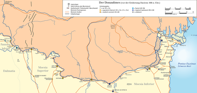
English: Map of Limes in Serbia, Romania and Bulgaria (Donaulimes/system of fortifications representing the boundary of Roman control ; shoreline of the time since Liviu Giosan, et al., “Young Danube delta documents stable Black Sea level since the middle Holocene: Morphodynamic, paleogeographic, and archaeological implications.” Geology 34.9 (2006), 757-760 and “Early Anthropogenic Transformation of the Danube-Black Sea System”, Scientific Reports 2 (2012), 10.1038/srep00582; Luminiţa Preoteasa, et al., “Coastal changes from open coast to present lagoon system in Histria region (Danube Delta).” Journal of Coastal Research 65 (2013), 564-569; Filip Florin, Liviu Giosan, “Evolution of Chilia lobes of the Danube delta: Reorganization of deltaic processes under cultural pressures”. Anthropocene 5 (2014), 65–70; Guénaëlle Bony, et al., “History and influence of the Danube delta lobes on the evolution of the ancient harbour of Orgame (Dobrogea, Romania)”. Journal of Archaeological Science 61 (2015), 186-203; Luminiţa Preoteasa, et al., “The evolution of an asymmetric deltaic lobe (Sf. Gheorghe, Danube) in association with cyclic development of the river-mouth bar: Long-term pattern and present adaptations to human-induced sediment depletion”, Geomorphology 253 (2016), 59–73.
Deutsch: Karte des Donaulimes in Serbien, Rumänien und Bulgarien. Suchbegriffe (Auswahl): Partiscum (Szeged), Tisia (Theiss), Tibiscus (Timis), Mures, Bassiana, Pannonia Inferior, Acumincum, Rittium, Burgenae, Taurunum (Zemun), Sigidunum (Belgrad), Octavum, Tricornium, Aureus Mons, Dalmatia, Viminatium, Lederata, Cuppae, Novae, Taliatae, Moesia Superior, Horreum Magri (Cuprijaa), Novae, Taliatae, Tekija, Sip, Karatas, Pontes, Egeta, Aquae (Prahovo), Bononia (Widin), Castra Martis (Kula), Ratiaria, Romuliana (Gamzigrad), Rabon (Jiu), Alutus (Olt), Oescus, Augustae, Oescus (Iskar), Dimum, Novae (Swishtow), Jairus (Yantra), Naparis (Ialomita), Moesia Inferior, Durostorum (Silistra), Sucidava (Celei), Pontus Euxinus (Schwarzes Meer), Tropaeum Traiani (Adamclisi), Parthenopolis (Movila), Callatis (Mangalia), Civitas Ausdecensium, Histria, Axiopolis (Cernavoda), Ulmetum, Argamum (Iancina), Troesmis, Cius, Carsium (Hârsova), Topalu, Noviodunum, Aegyssus (Tulcea), Salsovia (Mahmudia), Halmyris (Fundeni), Buzau, Hyerasus (Sereth), Pyretus (Pruth), Moldavia (Moldau) |
| תאריך יצירה | |
| מקור | נוצר על־ידי מעלה היצירה/Source of Information: Putzger – Historischer Weltatlas, 89. Auflage, 1965; Westermanns Großer Atlas zur Weltgeschichte, 1978; |
| יוצר | Ziegelbrenner |
רישיון
אני, בעל זכויות היוצרים על היצירה הזאת, מפרסם אותה בזאת תחת הרישיונות הבאים:

|
מוענקת בכך הרשות להעתיק, להפיץ או לשנות את המסמך הזה, לפי תנאי הרישיון לשימוש חופשי במסמכים של גנו, גרסה 1.2 או כל גרסה מאוחרת יותר שתפורסם על־ידי המוסד לתוכנה חופשית; ללא פרקים קבועים, ללא טקסט עטיפה קדמית וללא טקסט עטיפה אחורית. עותק של הרישיון כלול בפרק שכותרתו הרישיון לשימוש חופשי במסמכים של גנו. |
הקובץ הזה מתפרסם לפי תנאי רישיונות קריאייטיב קומונז ייחוס-שיתוף זהה 3.0 לא מותאם, 2.5 כללי, 2.0 כללי ו־1.0 כללי.
- הנכם רשאים:
- לשתף – להעתיק, להפיץ ולהעביר את העבודה
- לערבב בין עבודות – להתאים את העבודה
- תחת התנאים הבאים:
- ייחוס – יש לתת ייחוס הולם, לתת קישור לרישיון, ולציין אם נעשו שינויים. אפשר לעשות את זה בכל צורה סבירה, אבל לא בשום צורה שמשתמע ממנה שמעניק הרישיון תומך בך או בשימוש שלך.
- שיתוף זהה – אם תיצרו רמיקס, תשנו, או תבנו על החומר, חובה עליכם להפיץ את התרומות שלך לפי תנאי רישיון זהה או תואם למקור.
הנכם מוזמנים לבחור את הרישיון הרצוי בעיניכם.

|
This map has been made or improved in the German Kartenwerkstatt (Map Lab). You can propose maps to improve as well.
|
היסטוריית הקובץ
ניתן ללחוץ על תאריך/שעה כדי לראות את הקובץ כפי שנראה באותו זמן.
| תאריך/שעה | תמונה ממוזערת | ממדים | משתמש | הערה | |
|---|---|---|---|---|---|
| נוכחית | 17:12, 13 באפריל 2018 | | 1,181 × 2,509 (908 ק"ב) | Julieta39 | Little anachronism about Ialomita : Herodotus said Naparis (Helibacia is cited by Simocatta, centuries later) |
| 15:00, 13 באפריל 2018 |  | 1,181 × 2,509 (908 ק"ב) | Julieta39 | See discussion page please. | |
| 17:37, 28 באפריל 2014 |  | 1,181 × 2,509 (853 ק"ב) | Ziegelbrenner | 2014-04-28 | |
| 17:13, 6 בפברואר 2013 |  | 1,390 × 2,953 (579 ק"ב) | Ziegelbrenner | 2013-02-06 | |
| 15:32, 14 בנובמבר 2011 |  | 787 × 1,575 (269 ק"ב) | Ziegelbrenner | 2011-11-14 | |
| 14:13, 28 בינואר 2011 |  | 1,181 × 2,510 (838 ק"ב) | Ziegelbrenner | 2011-01-28 | |
| 14:43, 26 בינואר 2011 |  | 1,113 × 2,363 (769 ק"ב) | Ziegelbrenner | 2011-01-26 | |
| 14:41, 26 בינואר 2011 |  | 1,772 × 3,765 (1.44 מ"ב) | Ziegelbrenner | Reverted to version as of 14:17, 20 January 2011 | |
| 14:38, 26 בינואר 2011 |  | 3,414 × 7,252 (2.12 מ"ב) | Ziegelbrenner | 2011-01-26 | |
| 17:17, 20 בינואר 2011 |  | 1,772 × 3,765 (1.44 מ"ב) | Ziegelbrenner | 2011-01-20 |
שימוש בקובץ
הדף הבא משתמש בקובץ הזה:
שימוש גלובלי בקובץ
אתרי הוויקי השונים הבאים משתמשים בקובץ זה:
- שימוש באתר bg.wikipedia.org
- שימוש באתר ca.wikipedia.org
- שימוש באתר cs.wikipedia.org
- שימוש באתר cy.wikipedia.org
- שימוש באתר de.wikipedia.org
- Abrittus
- Moesia
- Limes (Grenzwall)
- Donaulimes
- Moesia inferior
- Kastell Iatrus
- Wikipedia:Redaktion Altertum/Römischer Limes
- Wikipedia:Redaktion Altertum/Römischer Limes/Pictothek
- Wikipedia Diskussion:Redaktion Altertum/Römischer Limes/Archiv/2010
- Classis Pannonica
- Wikipedia:Kartenwerkstatt/Archiv/2011-01
- Benutzer Diskussion:Ziegelbrenner/Archiv 2011
- Benutzer:Ziegelbrenner/Meine Bilder auf Commons
- Welterbe in Rumänien
- Dux Moesiae primae
- Dux Daciae ripensis
- Dux Moesiae secundae
- Benutzer:Drekamu/Antike Geographie
- Liste der Kastelle am moesischen Limes
- שימוש באתר en.wikipedia.org
- שימוש באתר eo.wikipedia.org
- שימוש באתר es.wikipedia.org
- שימוש באתר eu.wikipedia.org
- שימוש באתר fa.wikipedia.org
- שימוש באתר fr.wikipedia.org
- שימוש באתר gl.wikipedia.org
- שימוש באתר hr.wikipedia.org
- שימוש באתר it.wikipedia.org