
קובץ:MSH80 mudline muddy river with USGS scientist 10-23-80.jpg

גודל התצוגה המקדימה הזאת: 800 × 536 פיקסלים. רזולוציות אחרות: 320 × 215 פיקסלים | 640 × 429 פיקסלים | 1,024 × 687 פיקסלים | 1,280 × 858 פיקסלים | 2,904 × 1,947 פיקסלים.
לקובץ המקורי (2,904 × 1,947 פיקסלים, גודל הקובץ: 2.64 מ"ב, סוג MIME: image/jpeg)
| זהו קובץ שמקורו במיזם ויקישיתוף. תיאורו בדף תיאור הקובץ המקורי (בעברית) מוצג למטה. |
תקציר
| תיאור |
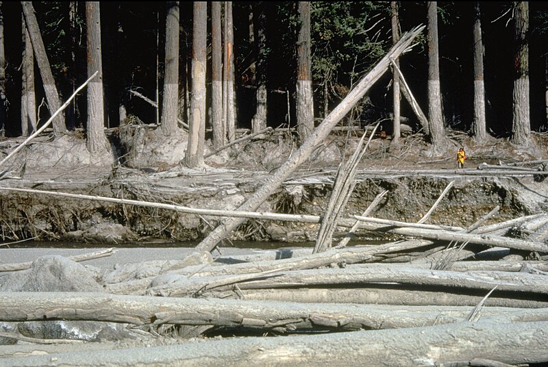
English: (copied description from USGS site): Nearly 135 miles (220 kilometers) of river channels surrounding the volcano [Mt. St. Helens] were affected by the lahars of May 18, 1980. A mudline left behind on trees shows depths reached by the mud. A scientist (middle right) gives scale. This view is along the Muddy River, southeast of Mount St. Helens. |
| תאריך יצירה | צולם ב- 23 באוקטובר 1980 |
| מקור | http://vulcan.wr.usgs.gov/Glossary/Lahars/description_lahars.html |
| יוצר | Lyn Topinka, USGS |
רישיון
This image is in the public domain in the United States because it only contains materials that originally came from the United States Geological Survey, an agency of the United States Department of the Interior. For more information, see the official USGS copyright policy.
|
היסטוריית הקובץ
ניתן ללחוץ על תאריך/שעה כדי לראות את הקובץ כפי שנראה באותו זמן.
| תאריך/שעה | תמונה ממוזערת | ממדים | משתמש | הערה | |
|---|---|---|---|---|---|
| נוכחית | 06:35, 12 בדצמבר 2022 | | 1,947 × 2,904 (2.64 מ"ב) | Hike395 | less jpeg compression, re-crop from original |
| 05:32, 10 באוקטובר 2011 |  | 1,948 × 2,916 (1.21 מ"ב) | Materialscientist | crop frame | |
| 18:02, 2 בספטמבר 2010 |  | 2,048 × 3,072 (4.07 מ"ב) | Awickert | {{Information |Description={{en|1=(copied description from USGS site): Nearly 135 miles (220 kilometers) of river channels surrounding the volcano [Mt. St. Helens] were affected by the lahars of May 18, 1980. A mudline left behind on trees shows depths re |
שימוש בקובץ
הדף הבא משתמש בקובץ הזה:
שימוש גלובלי בקובץ
אתרי הוויקי השונים הבאים משתמשים בקובץ זה:
- שימוש באתר bg.wikipedia.org
- שימוש באתר bn.wikipedia.org
- שימוש באתר cs.wikipedia.org
- שימוש באתר de.wikipedia.org
- שימוש באתר en.wikipedia.org
- שימוש באתר es.wikipedia.org
- שימוש באתר fr.wikipedia.org
- שימוש באתר id.wikipedia.org
- שימוש באתר it.wikipedia.org
- שימוש באתר nl.wikipedia.org
- שימוש באתר oc.wikipedia.org
- שימוש באתר ro.wikipedia.org
- שימוש באתר sk.wikipedia.org
- שימוש באתר sv.wikipedia.org
- שימוש באתר tr.wikipedia.org
- שימוש באתר uk.wikipedia.org
- שימוש באתר vi.wikipedia.org
- שימוש באתר www.wikidata.org
- שימוש באתר zh.wikipedia.org