
קובץ:Manchester Free Trade Hall (Radisson Edwardian Hotel).jpg
לקובץ המקורי (640 × 640 פיקסלים, גודל הקובץ: 604 ק"ב, סוג MIME: image/jpeg)
| זהו קובץ שמקורו במיזם ויקישיתוף. תיאורו בדף תיאור הקובץ המקורי (בעברית) מוצג למטה. |
.jpg)
.jpg?uselang=he)
תקציר
| תיאור |
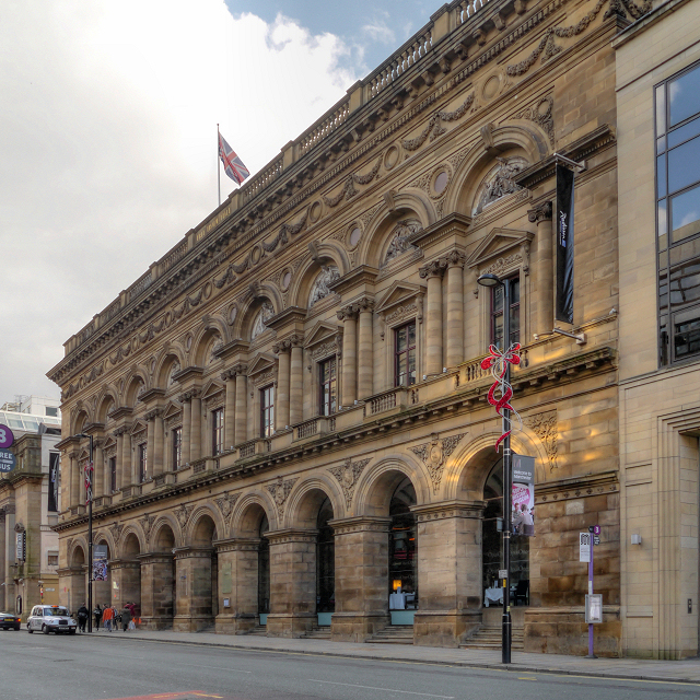
English: The Peter Street frontage of the Radisson Edwardian Hotel, originally built as the Free Trade Hall.
The Free Trade Hall was a public hall constructed in 1853–6 to commemorate the repeal of the Corn Laws in 1846. The hall was funded by public subscription and became a concert hall and home of the Hallé Orchestra in 1858. The interior of the hall had to be rebuilt after bombing during the Manchester Blitz left it an empty shell; it re-opened in 1951. As well as housing the Hallé Orchestra, it was used for pop and rock concerts; it was Manchester's premier concert venue until the construction of the Bridgewater Hall in 1996. When the Hallé Orchestra moved to the Bridgewater Hall in 1996, the Free Trade Hall was closed by Manchester City Council. In 1997, the building was sold to private developers and, despite much opposition because of its historical significance, planning approval was eventually granted to convert it to a hotel, retaining the original facade was, the main staircase and the 1950s statues that were formerly attached to its rear wall. The hotel opened in 2004. The hall is designated as a Grade II* listed building. A red plaque on the wall records that it was built on St Peter's Fields, the site of the (in)famous Peterloo Massacre in 1819. |
| תאריך יצירה | |
| מקור | https://www.geograph.org.uk/photo/3178858 |
| יוצר | David Dixon |
| ייחוס (required by the license) | David Dixon / Manchester Free Trade Hall (Radisson Edwardian Hotel) / |
| מיקום המצלמה | | תמונה זו ותמונות נוספות במיקום: OpenStreetMap |
|---|
.jpg¶ms=053.478060_N_-002.247600_E_globe:Earth_type:camera_source:geograph-osgb36(SJ83669795)_heading:112.00&language=he)
| מיקום האובייקט | | תמונה זו ותמונות נוספות במיקום: OpenStreetMap |
|---|
.jpg¶ms=053.477880_N_-002.247100_E_globe:Earth_class:object_type:object_source:geograph-osgb36(SJ83699793)_heading:112.00&language=he)
רישיון

|
This image was taken from the Geograph project collection. See this photograph's page on the Geograph website for the photographer's contact details. The copyright on this image is owned by David Dixon and is licensed for reuse under the Creative Commons Attribution-ShareAlike 2.0 license.
|
- הנכם רשאים:
- לשתף – להעתיק, להפיץ ולהעביר את העבודה
- לערבב בין עבודות – להתאים את העבודה
- תחת התנאים הבאים:
- ייחוס – יש לתת ייחוס הולם, לתת קישור לרישיון, ולציין אם נעשו שינויים. אפשר לעשות את זה בכל צורה סבירה, אבל לא בשום צורה שמשתמע ממנה שמעניק הרישיון תומך בך או בשימוש שלך.
- שיתוף זהה – אם תיצרו רמיקס, תשנו, או תבנו על החומר, חובה עליכם להפיץ את התרומות שלך לפי תנאי רישיון זהה או תואם למקור.
היסטוריית הקובץ
ניתן ללחוץ על תאריך/שעה כדי לראות את הקובץ כפי שנראה באותו זמן.
| תאריך/שעה | תמונה ממוזערת | ממדים | משתמש | הערה | |
|---|---|---|---|---|---|
| נוכחית | 14:22, 21 בינואר 2014 | | 640 × 640 (604 ק"ב) | Ham II | User created page with UploadWizard |
שימוש בקובץ
הדף הבא משתמש בקובץ הזה:
שימוש גלובלי בקובץ
אתרי הוויקי השונים הבאים משתמשים בקובץ זה:
- שימוש באתר azb.wikipedia.org
- שימוש באתר az.wikipedia.org
- שימוש באתר en.wikipedia.org
- שימוש באתר ru.wikipedia.org
- שימוש באתר zh.wikipedia.org
.jpg)