
קובץ:Map Cleomenean War-en.svg

גודל התצוגה המקדימה הזאת מסוג PNG של קובץ ה־SVG הזה: 431 × 542 פיקסלים. רזולוציות אחרות: 191 × 240 פיקסלים | 382 × 480 פיקסלים | 611 × 768 פיקסלים | 814 × 1,024 פיקסלים | 1,628 × 2,048 פיקסלים.
לקובץ המקורי (קובץ SVG, הגודל המקורי: 431 × 542 פיקסלים, גודל הקובץ: 982 ק"ב)
| זהו קובץ שמקורו במיזם ויקישיתוף. תיאורו בדף תיאור הקובץ המקורי (בעברית) מוצג למטה. |
תקציר
| תיאור |
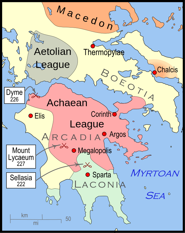
English: Mainland Greece during the time of the Cleomenean War, ca. 228 BCE |
| תאריך יצירה | |
| מקור | נוצר על־ידי מעלה היצירה |
| יוצר | MapMaster |
| גרסאות אחרות |
[]
|


-pt.svg)


References
The map itself was built using File:Greece map blank.svg, adding the now-drained Lake Copais. Towns were placed using geographic coordinates.
The borders of the various political entities were taken from several sources:
- Chamoux, François (2002) Hellenistic civilization, Wiley-Blackwell, ISBN 9780631222422, p. 206, for the Achaean League. I did not use this for the Aetolian League, since this map shows the later and larger borders of the Aetolian League, after the Cleomenean War.
- Gabbert, Janice J. (1997) Antigonus II Gonatas: a political biography, Routledge, ISBN 9780415018999 , p. 33, for the area under the control of Macedon.
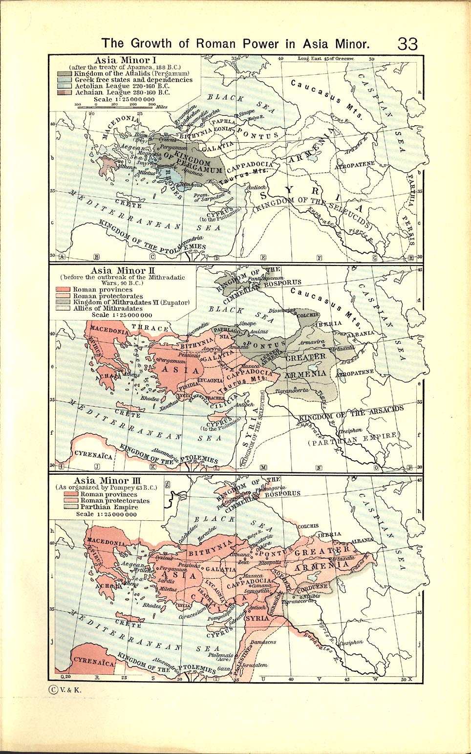
- Shepherd, William (1911) "The Growth of Roman Power in Asia Minor", Historical Atlas, Henry Holt and Company. p. 33, was used as the primary reference for the Aetolian League.
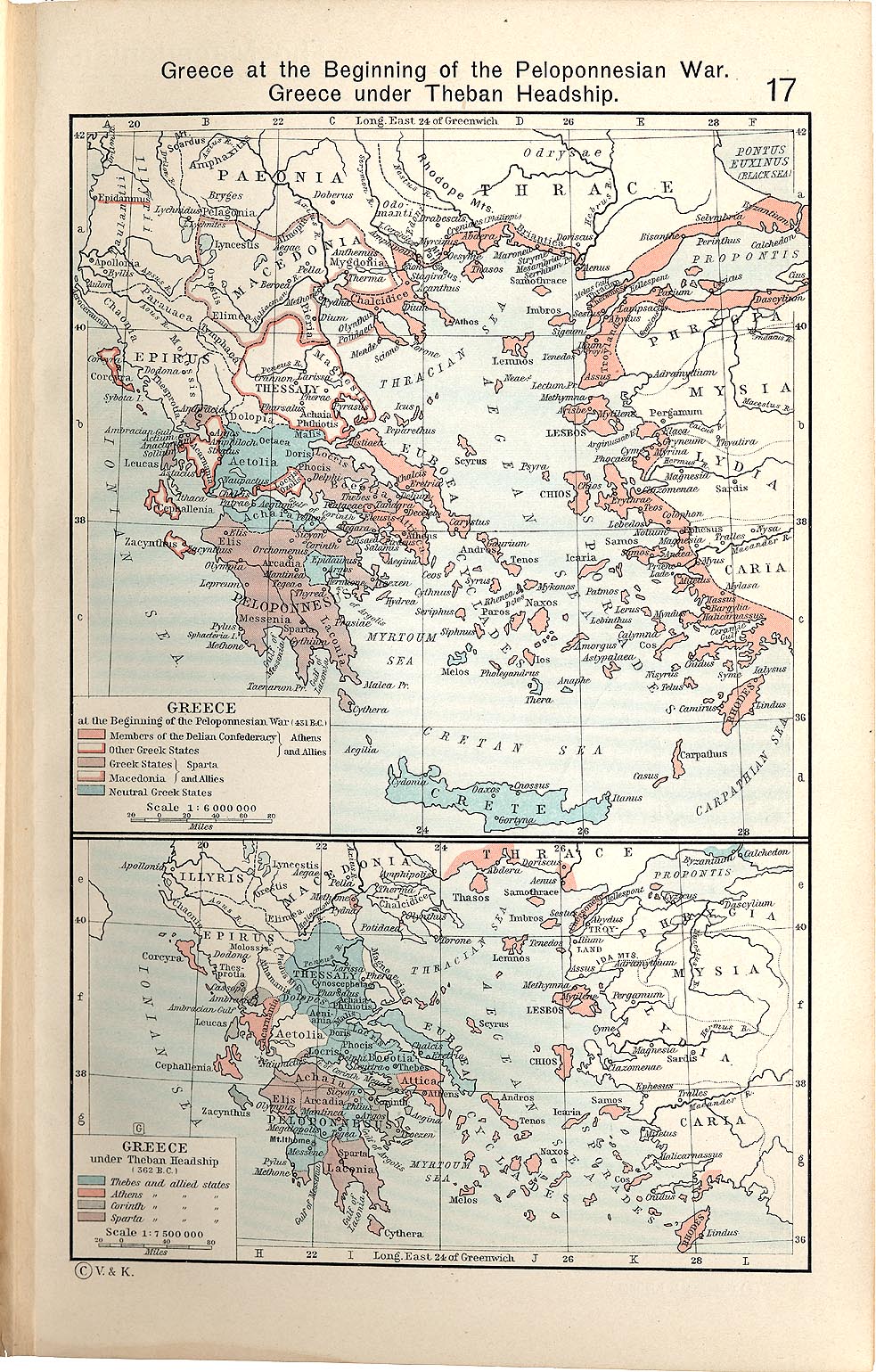
- Shepherd, William (1911) "Greece under Theban Headship", Historical Atlas, Henry Holt and Company. p. 17, was used as the primary reference for the Spartan borders. When there was a conflict with the Chamoux map, I used the Chamoux map.
Any additional information on borders and areas under control would be very welcome.
Similar maps

רישיון
אני, בעל זכויות היוצרים על עבודה זו, מפרסם בזאת את העבודה תחת הרישיון הבא:
הקובץ הזה מתפרסם לפי תנאי רישיון קריאייטיב קומונז ייחוס-שיתוף זהה 3.0 לא מותאם.
- הנכם רשאים:
- לשתף – להעתיק, להפיץ ולהעביר את העבודה
- לערבב בין עבודות – להתאים את העבודה
- תחת התנאים הבאים:
- ייחוס – יש לתת ייחוס הולם, לתת קישור לרישיון, ולציין אם נעשו שינויים. אפשר לעשות את זה בכל צורה סבירה, אבל לא בשום צורה שמשתמע ממנה שמעניק הרישיון תומך בך או בשימוש שלך.
- שיתוף זהה – אם תיצרו רמיקס, תשנו, או תבנו על החומר, חובה עליכם להפיץ את התרומות שלך לפי תנאי רישיון זהה או תואם למקור.
היסטוריית הקובץ
ניתן ללחוץ על תאריך/שעה כדי לראות את הקובץ כפי שנראה באותו זמן.
| תאריך/שעה | תמונה ממוזערת | ממדים | משתמש | הערה | |
|---|---|---|---|---|---|
| נוכחית | 07:57, 12 בינואר 2010 | | 542 × 431 (982 ק"ב) | MapMaster | {{Information |Description={{en|1=A map of Greece during the Cleomenean War}} |Source={{own}} |Author=MapMaster |Date=11 January 2010 |Permission= |other_versions= }} Category:Maps of the history of Greece |
שימוש בקובץ
הדפים הבאים משתמשים בקובץ הזה:
שימוש גלובלי בקובץ
אתרי הוויקי השונים הבאים משתמשים בקובץ זה:
- שימוש באתר ar.wikipedia.org
- שימוש באתר bg.wikipedia.org
- שימוש באתר ca.wikipedia.org
- שימוש באתר el.wikipedia.org
- שימוש באתר en.wikipedia.org
- שימוש באתר et.wikipedia.org
- שימוש באתר it.wikipedia.org
- שימוש באתר ja.wikipedia.org
- שימוש באתר ko.wikipedia.org
- שימוש באתר nl.wikipedia.org
- שימוש באתר sh.wikipedia.org
- שימוש באתר tr.wikipedia.org
- שימוש באתר uk.wikipedia.org
- שימוש באתר vi.wikipedia.org
- שימוש באתר www.wikidata.org
- שימוש באתר zh.wikipedia.org