
קובץ:Mexico City ESA412648.jpg

לקובץ המקורי (7,288 × 4,599 פיקסלים, גודל הקובץ: 9.14 מ"ב, סוג MIME: image/jpeg)
| זהו קובץ שמקורו במיזם ויקישיתוף. תיאורו בדף תיאור הקובץ המקורי (בעברית) מוצג למטה. |
תקציר
| תיאור |
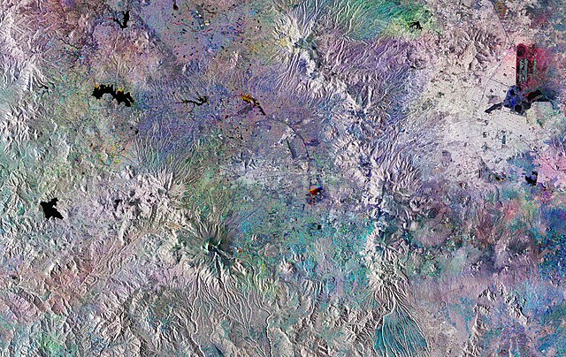
English: The Copernicus Sentinel-1 mission takes us over Mexico City. This huge, densely-populated capital can be seen in the top right of the image. It is home to almost nine million people, with the Greater Mexico City area recording a population of over 21 million. This makes it the largest Spanish-speaking city in the world.
This striking image has been created using three Copernicus Sentinel-1 acquisitions from 28 July, 27 August and 26 September 2018, overlaid in red, green and blue, respectively. Where we see explosions of colour, changes have occurred between the different acquisitions. In the left of the image, three bodies of water are shown in black: Villa Victoria, Valle de Bravo, and Tepetitlán. Water is significant to the development of Mexico City, which is thought to have been built over a lake by the Aztecs around 1325. Today, the city finds itself in a precarious situation in terms of water supply in spite of the regular flash floods and heavy rainfall it experiences during the wet season from June and September. In the top right, we can see the round structure of El Caracol meaning ‘the snail’ in Spanish. Currently used as a reservoir for industrial facilities within Mexico City, there are plans for this to become a wastewater treatment plant. A 62 km-long sewer tunnel is also due to begin operating this year. The Cumbres del Ajusco national park is shown to the southwest of the capital, in an area of the image that shows colourful dots forming a circle. Famous for being up to almost 4000 m above sea level at its highest elevation, it is one of many national parks surrounding the capital. Volcanoes are also dotted around this area. Popocatépetl, to the south east of Mexico City, last erupted in September 2018. Sentinel-1 is a two-satellite mission to supply the coverage and data delivery needed for Europe’s Copernicus environmental monitoring programme. The satellites each carry an advanced radar instrument to provide an all-weather, day-and-night supply of imagery of Earth’s surface. This image is also featured on theEarth from Space video programme. |
| תאריך יצירה | צולם ב־ 2018 |
| מקור | http://www.esa.int/spaceinimages/Images/2018/11/Mexico_City |
| יוצר | European Space Agency |
| אישורים והיתרים (שימוש חוזר בקובץ זה) |
contains modified Copernicus Sentinel data (2018), processed by ESA,CC BY-SA 3.0 IGO |
| גרסאות אחרות |
|
| Title | Mexico City |
| System | Copernicus |
| Set | Earth observation image of the week |
| Mission | Sentinel-1 |
| Activity | Observing the Earth |

רישיון
This media was created by the European Space Agency (ESA).
Where expressly so stated, images or videos are covered by the Creative Commons Attribution-ShareAlike 3.0 IGO (CC BY-SA 3.0 IGO) licence, ESA being an Intergovernmental Organisation (IGO), as defined by the CC BY-SA 3.0 IGO licence. The user is allowed under the terms and conditions of the CC BY-SA 3.0 IGO license to Reproduce, Distribute and Publicly Perform the ESA images and videos released under CC BY-SA 3.0 IGO licence and the Adaptations thereof, without further explicit permission being necessary, for as long as the user complies with the conditions and restrictions set forth in the CC BY-SA 3.0 IGO licence, these including that:
See the ESA Creative Commons copyright notice for complete information, and this article for additional details.
|
 | |
הקובץ הזה מתפרסם לפי תנאי רישיון קריאייטיב קומונז ייחוס-שיתוף זהה 3.0 ארגון ממשלתי בין־לאומי. ייחוס: ESA, CC BY-SA IGO 3.0
| ||

|
This image contains data from a satellite in the Copernicus Programme, such as Sentinel-1, Sentinel-2 or Sentinel-3. Attribution is required when using this image.
ייחוס: Contains modified Copernicus Sentinel data 2018
The use of Copernicus Sentinel Data is regulated under EU law (Commission Delegated Regulation (EU) No 1159/2013 and Regulation (EU) No 377/2014). Relevant excerpts:
Free access shall be given to GMES dedicated data [...] made available through GMES dissemination platforms [...].
Access to GMES dedicated data [...] shall be given for the purpose of the following use in so far as it is lawful:
GMES dedicated data [...] may be used worldwide without limitations in time.
GMES dedicated data and GMES service information are provided to users without any express or implied warranty, including as regards quality and suitability for any purpose. |
היסטוריית הקובץ
ניתן ללחוץ על תאריך/שעה כדי לראות את הקובץ כפי שנראה באותו זמן.
| תאריך/שעה | תמונה ממוזערת | ממדים | משתמש | הערה | |
|---|---|---|---|---|---|
| נוכחית | 16:14, 3 באפריל 2019 | | 4,599 × 7,288 (9.14 מ"ב) | Fæ | European Space Agency, Id 412648, http://www.esa.int/spaceinimages/Images/2018/11/Mexico_City, User:Fæ/Project_list/ESA |
שימוש בקובץ
הדף הבא משתמש בקובץ הזה:
שימוש גלובלי בקובץ
אתרי הוויקי השונים הבאים משתמשים בקובץ זה:
- שימוש באתר ar.wikipedia.org
- שימוש באתר arz.wikipedia.org
- שימוש באתר ast.wikipedia.org
- שימוש באתר ca.wikipedia.org
- שימוש באתר ceb.wikipedia.org
- שימוש באתר ce.wikipedia.org
- שימוש באתר cy.wikipedia.org
- שימוש באתר da.wikipedia.org
- שימוש באתר de.wikivoyage.org
- שימוש באתר el.wikipedia.org
- שימוש באתר eo.wikipedia.org
- שימוש באתר fi.wikipedia.org
- שימוש באתר fr.wikivoyage.org
- שימוש באתר ga.wikipedia.org
- שימוש באתר gl.wikipedia.org
- שימוש באתר hy.wikipedia.org
- שימוש באתר ia.wikipedia.org
- שימוש באתר ilo.wikipedia.org
- שימוש באתר mzn.wikipedia.org
- שימוש באתר nn.wikipedia.org
- שימוש באתר no.wikipedia.org
- שימוש באתר pl.wikipedia.org
- שימוש באתר pt.wikipedia.org
- שימוש באתר ro.wikipedia.org
- שימוש באתר ru.wikipedia.org
- שימוש באתר sk.wikipedia.org
- שימוש באתר sr.wikipedia.org
- שימוש באתר tt.wikipedia.org
- שימוש באתר uk.wikipedia.org
- שימוש באתר vec.wikipedia.org
- שימוש באתר vi.wikipedia.org
- שימוש באתר www.wikidata.org