
קובץ:Missouri River basin map.png

גודל התצוגה המקדימה הזאת: 800 × 575 פיקסלים. רזולוציות אחרות: 320 × 230 פיקסלים | 640 × 460 פיקסלים | 1,024 × 736 פיקסלים | 1,280 × 920 פיקסלים | 1,496 × 1,075 פיקסלים.
לקובץ המקורי (1,496 × 1,075 פיקסלים, גודל הקובץ: 2.63 מ"ב, סוג MIME: image/png)
| זהו קובץ שמקורו במיזם ויקישיתוף. תיאורו בדף תיאור הקובץ המקורי (בעברית) מוצג למטה. |
תקציר
| תיאור |
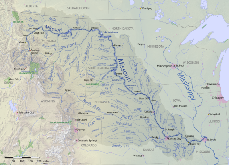
English: Map of the Missouri River drainage basin in the US and Canada. made using USGS and Natural Earth data. Replacement for File:Missouririvermap.jpg. |
| תאריך יצירה | |
| מקור | נוצר על־ידי מעלה היצירה |
| יוצר | Shannon1 |
.png)
רישיון
אני, בעל זכויות היוצרים על היצירה הזאת, מפרסם אותה בזאת תחת הרישיונות הבאים:

|
מוענקת בכך הרשות להעתיק, להפיץ או לשנות את המסמך הזה, לפי תנאי הרישיון לשימוש חופשי במסמכים של גנו, גרסה 1.2 או כל גרסה מאוחרת יותר שתפורסם על־ידי המוסד לתוכנה חופשית; ללא פרקים קבועים, ללא טקסט עטיפה קדמית וללא טקסט עטיפה אחורית. עותק של הרישיון כלול בפרק שכותרתו הרישיון לשימוש חופשי במסמכים של גנו. |
This file is licensed under the Creative Commons Attribution-Share Alike 4.0 International, 3.0 Unported, 2.5 Generic, 2.0 Generic and 1.0 Generic license.
- הנכם רשאים:
- לשתף – להעתיק, להפיץ ולהעביר את העבודה
- לערבב בין עבודות – להתאים את העבודה
- תחת התנאים הבאים:
- ייחוס – יש לתת ייחוס הולם, לתת קישור לרישיון, ולציין אם נעשו שינויים. אפשר לעשות את זה בכל צורה סבירה, אבל לא בשום צורה שמשתמע ממנה שמעניק הרישיון תומך בך או בשימוש שלך.
- שיתוף זהה – אם תיצרו רמיקס, תשנו, או תבנו על החומר, חובה עליכם להפיץ את התרומות שלך לפי תנאי רישיון זהה או תואם למקור.
הנכם מוזמנים לבחור את הרישיון הרצוי בעיניכם.
היסטוריית הקובץ
ניתן ללחוץ על תאריך/שעה כדי לראות את הקובץ כפי שנראה באותו זמן.
| תאריך/שעה | תמונה ממוזערת | ממדים | משתמש | הערה | |
|---|---|---|---|---|---|
| נוכחית | 03:15, 9 באפריל 2018 | | 1,075 × 1,496 (2.63 מ"ב) | Shannon1 | missing label |
| 00:56, 31 במרץ 2018 |  | 1,080 × 1,500 (2.8 מ"ב) | Shannon1 | slight fixes | |
| 22:30, 30 במרץ 2018 |  | 1,078 × 1,500 (2.78 מ"ב) | Shannon1 | {{Information |description ={{en|1=Map of the Missouri River drainage basin in the US and Canada. made using USGS and Natural Earth data. Replacement for File:Missouririvermap.jpg.}} |source =Own work |author =Shannon1 |date =2018-03-21 }} Category:Missouri River |
שימוש בקובץ
הדף הבא משתמש בקובץ הזה:
שימוש גלובלי בקובץ
אתרי הוויקי השונים הבאים משתמשים בקובץ זה:
- שימוש באתר af.wikipedia.org
- שימוש באתר azb.wikipedia.org
- שימוש באתר az.wiktionary.org
- שימוש באתר ba.wikipedia.org
- שימוש באתר be.wikipedia.org
- שימוש באתר bh.wikipedia.org
- שימוש באתר bn.wikipedia.org
- שימוש באתר ca.wikipedia.org
- שימוש באתר cv.wikipedia.org
- שימוש באתר da.wikipedia.org
- שימוש באתר en.wikipedia.org
- Missouri River
- Grand River (South Dakota)
- User:Shannon1/Sandbox 5
- User:Shannon1/Maps
- Yellowstone expedition
- List of longest rivers of the United States (by main stem)
- List of tributaries of the Missouri River
- Wikipedia:Graphics Lab/Map workshop/Archive/Jul 2011
- List of dams in the Missouri River watershed
- User:Shannon1/Maps/to-do
- Joseph LaBarge
- Spread Eagle (steamboat)
- Emilie (steamboat)
- שימוש באתר es.wikipedia.org
- Iowa
- Dakota del Norte
- Dakota del Sur
- Denver
- Río Misuri
- Bismarck (Dakota del Norte)
- Misuri
- Río Yellowstone
- Lincoln (Nebraska)
- Omaha (Nebraska)
- Columbia (Misuri)
- Kansas City (Misuri)
- Topeka
- Río Marías
- Kansas City (Kansas)
- Río Cheyenne
- Río Gallatin
- Great Falls (Montana)
- Río Platte
- Río Milk
- Río James (Dakotas)
- Río Smoky Hill
- Río Saline (Kansas)
- Río Niobrara