
קובץ:Morrison Formation Brachiosauridae map.png

גודל התצוגה המקדימה הזאת: 627 × 600 פיקסלים. רזולוציות אחרות: 251 × 240 פיקסלים | 502 × 480 פיקסלים | 803 × 768 פיקסלים | 1,071 × 1,024 פיקסלים | 2,540 × 2,429 פיקסלים.
לקובץ המקורי (2,540 × 2,429 פיקסלים, גודל הקובץ: 73 ק"ב, סוג MIME: image/png)
| זהו קובץ שמקורו במיזם ויקישיתוף. תיאורו בדף תיאור הקובץ המקורי (בעברית) מוצג למטה. |
תקציר
| תיאור |
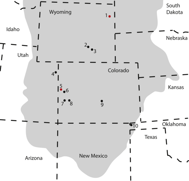
Map of occurrences of Brachiosauridae in the Upper Jurassic Morrison Formation. The locality of the pes described herein (1) and the type locality of Brachiosaurus altithorax (5) are highlighted in red. The gray area indicates the distribution of the Morrison Formation. 1, Bobcat Pit, Weston County, WY; 2, Freezeout Hills general, Carbon Co., WY; 3, Reed’s Quarry 13, Albany Co., WY; 4, Jensen/Jensen Quarry, Uintah Co., UT; 5, Fruita Paleontological Area general, Mesa Co., CO; 6, Riggs Quarry 13, Mesa Co., CO; 7, Dry Mesa Quarry, Mesa Co., CO; 8, Potter Creek Quarry, Montrose Co., CO; 9, Felch Quarry 1, Fremont Co., CO; 10, Kenton Pit 1, Cimarron Co., OK. Modified from Bonnan & Wedel (2004: fig. 2). |
| תאריך יצירה | |
| מקור | https://peerj.com/articles/5250/ |
| יוצר | Anthony Maltese, Emanuel Tschopp, Femke Holwerda, David Burnham |
| אישורים והיתרים (שימוש חוזר בקובץ זה) |
https://peerj.com/articles/5250.pdf |
רישיון
הקובץ הזה מתפרסם לפי תנאי רישיון קריאייטיב קומונז ייחוס 4.0 בין־לאומי.
- הנכם רשאים:
- לשתף – להעתיק, להפיץ ולהעביר את העבודה
- לערבב בין עבודות – להתאים את העבודה
- תחת התנאים הבאים:
- ייחוס – יש לתת ייחוס הולם, לתת קישור לרישיון, ולציין אם נעשו שינויים. אפשר לעשות את זה בכל צורה סבירה, אבל לא בשום צורה שמשתמע ממנה שמעניק הרישיון תומך בך או בשימוש שלך.
This file, which was originally posted to
https://peerj.com/articles/5250/, was reviewed on 24 July 2018 by reviewer Guanaco, who confirmed that it was available there under the stated license on that date.
|
היסטוריית הקובץ
ניתן ללחוץ על תאריך/שעה כדי לראות את הקובץ כפי שנראה באותו זמן.
| תאריך/שעה | תמונה ממוזערת | ממדים | משתמש | הערה | |
|---|---|---|---|---|---|
| נוכחית | 20:09, 10 באוגוסט 2018 | | 2,429 × 2,540 (73 ק"ב) | HerrAdams | Cropped 1 % horizontally, 1 % vertically using CropTool with precise mode. Removed border. |
| 23:17, 24 ביולי 2018 |  | 2,460 × 2,571 (111 ק"ב) | FunkMonk | == {{int:filedesc}} == {{Information |description=Map of occurrences of Brachiosauridae in the Upper Jurassic Morrison Formation. The locality of the pes described herein (1) and the type locality of Brachiosaurus altithorax (5) are highlighted in red. The gray area indicates the distribution of the Morrison Formation. 1, Bobcat Pit, Weston County, WY; 2, Freezeout Hills general, Carbon Co., WY; 3, Reed’s Quarry 13, Albany Co., WY; 4, Jensen/Jensen Quarry, Uintah Co., UT; 5, Fruita Paleontolo... |
שימוש בקובץ
הדף הבא משתמש בקובץ הזה:
שימוש גלובלי בקובץ
אתרי הוויקי השונים הבאים משתמשים בקובץ זה:
- שימוש באתר ar.wikipedia.org
- שימוש באתר ast.wikipedia.org
- שימוש באתר bg.wikipedia.org
- שימוש באתר ca.wikipedia.org
- שימוש באתר cs.wikipedia.org
- שימוש באתר en.wikipedia.org
- שימוש באתר eu.wikipedia.org
- שימוש באתר hr.wikipedia.org
- שימוש באתר hu.wikipedia.org
- שימוש באתר mk.wikipedia.org
- שימוש באתר nn.wikipedia.org
- שימוש באתר pl.wikipedia.org
- שימוש באתר sv.wikipedia.org
- שימוש באתר tr.wikipedia.org
- שימוש באתר www.wikidata.org
- שימוש באתר zh.wikipedia.org