
קובץ:NASA - Visible Earth, Lakes of the African Rift Valley.jpg

גודל התצוגה המקדימה הזאת: 800 × 523 פיקסלים. רזולוציות אחרות: 320 × 209 פיקסלים | 640 × 419 פיקסלים | 1,000 × 654 פיקסלים.
לקובץ המקורי (1,000 × 654 פיקסלים, גודל הקובץ: 127 ק"ב, סוג MIME: image/jpeg)
| זהו קובץ שמקורו במיזם ויקישיתוף. תיאורו בדף תיאור הקובץ המקורי (בעברית) מוצג למטה. |
תקציר
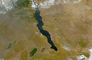
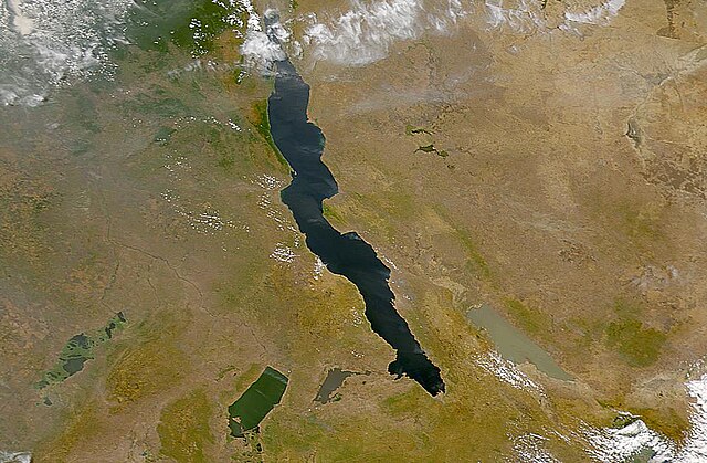
| תיאור | The lakes of the African Rift Valley exhibit wide variations in water color as can be seen in this SeaWiFS image. From left to right the lakes are: Lake Upembe, Lake Mweru, Lake Tanganyika (largest), and Lake Rukwa. This image spans the southeastern corner of the Democratic Republic of the Congo, northeastern Zambia, and southern Tanzania. |
| תאריך יצירה | |
| מקור | http://visibleearth.nasa.gov/view_rec.php?id=757 |
| יוצר | SeaWiFS Project, NASA/Goddard Space Flight Center, and ORBIMAGE |
| This image appeared on English Wikipedia's Main Page in the Did you know? column on 26 March 2004 (see archives). |
רישיון
| This image is from the Sea-viewing Wide Field-of-view Sensor (SeaWiFS) Project and more than 5 years old.
Satellite data captured by the SeaWIFS sensor are released into the public domain 5 years after capture. Data less than five years old can be re-used only for educational or scientific purposes; any commercial use of such images must be coordinated with GeoEye. [1] |
| This work has been released into the public domain by its copyright holder, GeoEye. This applies worldwide. יש מדינות שבהן הדבר אינו אפשרי על פי חוק, אם כך: GeoEye מעניק לכל אחד את הזכות להשתמש ביצירה הזאת לכל מטרה, ללא שום תנאי, אלא אם כן תנאים כאלה נדרשים לפי החוק.
|
היסטוריית הקובץ
ניתן ללחוץ על תאריך/שעה כדי לראות את הקובץ כפי שנראה באותו זמן.
| תאריך/שעה | תמונה ממוזערת | ממדים | משתמש | הערה | |
|---|---|---|---|---|---|
| נוכחית | 21:40, 25 בספטמבר 2005 | | 654 × 1,000 (127 ק"ב) | Moyogo | from NASA [http://visibleearth.nasa.gov/view_rec.php?id=757] Category:Africa |
שימוש בקובץ
הדף הבא משתמש בקובץ הזה:
שימוש גלובלי בקובץ
אתרי הוויקי השונים הבאים משתמשים בקובץ זה:
- שימוש באתר af.wikipedia.org
- שימוש באתר als.wikipedia.org
- שימוש באתר ar.wikipedia.org
- שימוש באתר ast.wiktionary.org
- שימוש באתר be.wikipedia.org
- שימוש באתר bh.wikipedia.org
- שימוש באתר ca.wikipedia.org
- שימוש באתר cs.wikipedia.org
- שימוש באתר de.wikipedia.org
- שימוש באתר de.wiktionary.org
- שימוש באתר en.wikipedia.org
- שימוש באתר eo.wikipedia.org
- שימוש באתר es.wikipedia.org
- שימוש באתר eu.wikipedia.org
- שימוש באתר fa.wikipedia.org
- שימוש באתר fi.wikipedia.org
- שימוש באתר fr.wikipedia.org
- שימוש באתר fr.wiktionary.org
- שימוש באתר ga.wikipedia.org
- שימוש באתר hi.wikipedia.org
- שימוש באתר id.wikipedia.org
- שימוש באתר is.wikipedia.org
- שימוש באתר ka.wikipedia.org
- שימוש באתר ku.wikipedia.org
- שימוש באתר ky.wikipedia.org
- שימוש באתר ln.wikipedia.org
- שימוש באתר lv.wikipedia.org
- שימוש באתר mg.wikipedia.org
- שימוש באתר ms.wikipedia.org