
קובץ:NavassaIsland.jpeg
גודל התצוגה המקדימה הזאת: 757 × 599 פיקסלים. רזולוציות אחרות: 303 × 240 פיקסלים | 606 × 480 פיקסלים | 970 × 768 פיקסלים | 1,280 × 1,013 פיקסלים | 1,829 × 1,448 פיקסלים.
לקובץ המקורי (1,829 × 1,448 פיקסלים, גודל הקובץ: 751 ק"ב, סוג MIME: image/jpeg)
| זהו קובץ שמקורו במיזם ויקישיתוף. תיאורו בדף תיאור הקובץ המקורי (בעברית) מוצג למטה. |


תקציר
| תיאור |
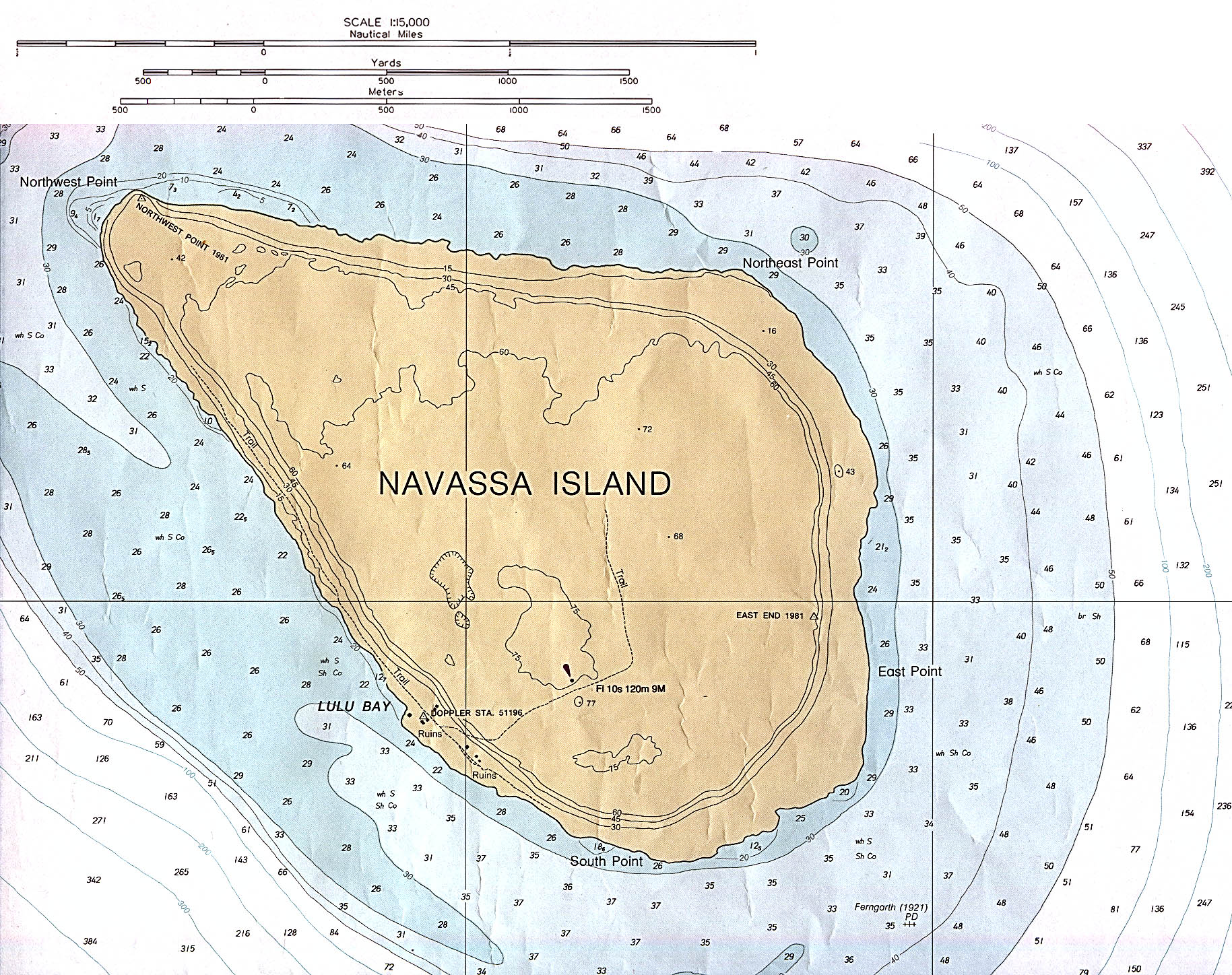
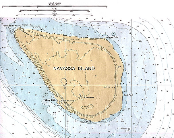
English: Navassa Island (Nautical Chart) original scale 1:15,000 Defense Mapping Agency 1982, revised 1991. |
| תאריך יצירה | 1982, revised 1991 |
| מקור | description source: http://www.lib.utexas.edu/maps/navassa_island.html |
| יוצר | US Government - Defense Mapping Agency |
רישיון
This work is in the public domain in the United States because it is a work prepared by an officer or employee of the United States Government as part of that person’s official duties under the terms of Title 17, Chapter 1, Section 105 of the US Code.
Note: This only applies to original works of the Federal Government and not to the work of any individual U.S. state, territory, commonwealth, county, municipality, or any other subdivision. This template also does not apply to postage stamp designs published by the United States Postal Service since 1978. (See § 313.6(C)(1) of Compendium of U.S. Copyright Office Practices). It also does not apply to certain US coins; see The US Mint Terms of Use.
|
 | |
| הקובץ הזה זוהה כקובץ חופשי מכל מגבלה ידועה תחת חוק זכויות היוצרים, כולל כל הזכויות הקשורות והסמוכות. | ||
היסטוריית הקובץ
ניתן ללחוץ על תאריך/שעה כדי לראות את הקובץ כפי שנראה באותו זמן.
| תאריך/שעה | תמונה ממוזערת | ממדים | משתמש | הערה | |
|---|---|---|---|---|---|
| נוכחית | 02:49, 10 בנובמבר 2012 | | 1,448 × 1,829 (751 ק"ב) | Rd232 | Higher resolution version of file, from original PCL source |
| 03:37, 16 בינואר 2006 |  | 429 × 466 (16 ק"ב) | *drew~commonswiki | *Description: Navassa Island *Source: En Wikipedia {{PD}} Category:Caribbean |
שימוש בקובץ
הדף הבא משתמש בקובץ הזה:
שימוש גלובלי בקובץ
אתרי הוויקי השונים הבאים משתמשים בקובץ זה:
- שימוש באתר cs.wikipedia.org
- שימוש באתר de.wikipedia.org
- שימוש באתר jv.wikipedia.org
- שימוש באתר ms.wikipedia.org