
קובץ:Nevado del Ruiz hazard map, from Wright and Pierson.png
אין גרסה ברזולוציה גבוהה יותר.
Nevado_del_Ruiz_hazard_map,_from_Wright_and_Pierson.png (675 × 450 פיקסלים, גודל הקובץ: 324 ק"ב, סוג MIME: image/png)
| זהו קובץ שמקורו במיזם ויקישיתוף. תיאורו בדף תיאור הקובץ המקורי (בעברית) מוצג למטה. |

|
This image (or all images in this category) uses inside labels or attached captions in a specific script or language and should be converted to a language neutral form. This would allow its use in all Wikimedia projects and, more importantly, all Wikimedia languages.
|

|
יש ליצור מחדש את התמונה map הזו באמצעות גרפיקה וקטורית כדוגמת קובץ SVG. לפעולה זו מספר יתרונות, כפי שניתן לקרוא (באנגלית) בדף Commons:Media for cleanup. אם ברשותכם קובץ SVG, אנא העלו אותו. לאחר מכן, החליפו תבנית זו בתבנית
{{vector version available|שם הקובץ.svg}} |
תקציר
| תיאור |
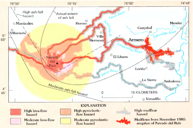
English: Volcanic hazard map for Nevado del Ruiz. Lahars from 1985 eruption (which killed around 23,000 people) shown in red.
Original caption: "Map showing hazards expected from an eruption of Nevado del Ruiz, Colombia. Such a map was prepared by INGEOMINAS (Colombian Institute of Geology and Mines) and circulated 1 month prior to the November 13, 1985, eruption of Nevado del Ruiz. Map shows danger from mudflows in the valley occupied by the town of Armero, Colombia, as well as areas affected by the hazards that resulted from this eruption. Circle denotes 20-kilometer limit." |
| תאריך יצירה | |
| מקור | Page 21 in Wright, Thomas L. and Pierson, Thomas C. (1992). Living with volcanoes (DJVU format), USGS Circular 1073. Bibliographic information and link to DJVU reader are online here. |
| יוצר | Wright, Thomas L. and Pierson, Thomas C. |
| גרסאות אחרות |
|

רישיון
This image is in the public domain in the United States because it only contains materials that originally came from the United States Geological Survey, an agency of the United States Department of the Interior. For more information, see the official USGS copyright policy.
|
היסטוריית הקובץ
ניתן ללחוץ על תאריך/שעה כדי לראות את הקובץ כפי שנראה באותו זמן.
| תאריך/שעה | תמונה ממוזערת | ממדים | משתמש | הערה | |
|---|---|---|---|---|---|
| נוכחית | 18:38, 19 בפברואר 2011 | | 450 × 675 (324 ק"ב) | Lluis tgn | Reverted to version as of 23:46, 31 March 2009. It was in catalan |
| 17:30, 19 בפברואר 2011 |  | 450 × 675 (284 ק"ב) | Jadelllave | ({{Information |Description={{ca|1=Mapa dels perills volcànics de Nevado del Ruiz. Els lahars de l'erupció de 1985 (que va matar al voltant de 23.000 persones) es mostren en vermell.}}}} | |
| 17:26, 19 בפברואר 2011 |  | 450 × 675 (284 ק"ב) | Jadelllave | Translation of the names to catalan. | |
| 02:46, 1 באפריל 2009 |  | 450 × 675 (324 ק"ב) | Avenue | {{Information |Description={{en|1=Volcanic hazard map for Nevado del Ruiz. Lahars from 1985 eruption (which killed around 23,000 people) shown in red. Original caption: "Map showing hazards expected from an eruption of Nevado del Ru |
שימוש בקובץ
הדף הבא משתמש בקובץ הזה:
שימוש גלובלי בקובץ
אתרי הוויקי השונים הבאים משתמשים בקובץ זה:
- שימוש באתר ast.wikipedia.org
- שימוש באתר en.wikipedia.org
- שימוש באתר es.wikipedia.org
- שימוש באתר fr.wikipedia.org
- שימוש באתר ga.wikipedia.org
- שימוש באתר id.wikipedia.org
- שימוש באתר it.wikipedia.org
- שימוש באתר it.wikibooks.org
- שימוש באתר ja.wikipedia.org
- שימוש באתר mk.wikipedia.org
- שימוש באתר nl.wikipedia.org
- שימוש באתר pt.wikipedia.org
- שימוש באתר ru.wikipedia.org
- שימוש באתר sl.wikipedia.org
- שימוש באתר uk.wikipedia.org
- שימוש באתר zh.wikipedia.org