
קובץ:Oslo Areas and barrier projection 2005.png
לקובץ המקורי (3,789 × 7,221 פיקסלים, גודל הקובץ: 268 ק"ב, סוג MIME: image/png)
| זהו קובץ שמקורו במיזם ויקישיתוף. תיאורו בדף תיאור הקובץ המקורי (בעברית) מוצג למטה. |
תקציר
| תיאור |
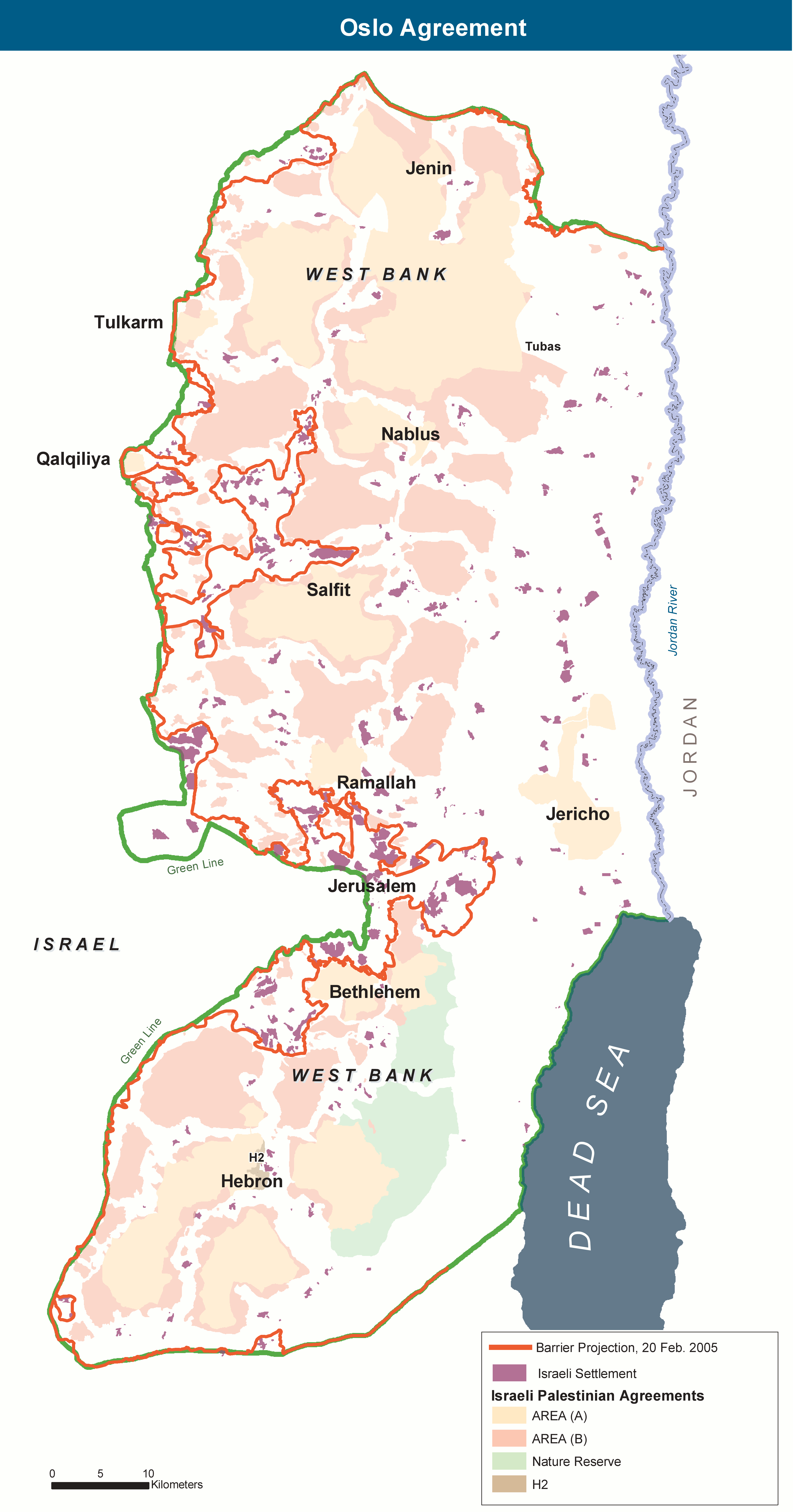
English: The Areas of the West Bank, created by the Oslo II Accord of 1995, and the Israeli Wall project as of 20 February 2005. |
| תאריך יצירה | |
| מקור | נוצר על־ידי מעלה היצירה. Adaptation of http://www.ochaopt.org/documents/WB_OsloGov&Barrier_July05.pdf on OCHAoPt Map Centre. |
| יוצר | Wickey-nl |
רישיון
| This image is a map derived from a United Nations map.
Unless stated otherwise, UN maps are to be considered in the public domain. This applies worldwide. UN maps are, in principle, open source material and you can use them in your work or for making your own map. UN requests however that you delete the UN name, logo and reference number upon any modification to the map. Content of your map will be your responsibility. You can state in your publication, if you wish, something like: based on UN map … (map name, map number, revision number and date). See: Geospatial Information Section. And: Geospatial, location data for a better world. |
 |
היסטוריית הקובץ
ניתן ללחוץ על תאריך/שעה כדי לראות את הקובץ כפי שנראה באותו זמן.
| תאריך/שעה | תמונה ממוזערת | ממדים | משתמש | הערה | |
|---|---|---|---|---|---|
| נוכחית | 15:01, 7 בנובמבר 2013 | | 7,221 × 3,789 (268 ק"ב) | Wickey-nl | User created page with UploadWizard |
שימוש בקובץ
הדפים הבאים משתמשים בקובץ הזה:
שימוש גלובלי בקובץ
אתרי הוויקי השונים הבאים משתמשים בקובץ זה:
- שימוש באתר ar.wikipedia.org
- שימוש באתר ca.wikipedia.org
- שימוש באתר de.wikipedia.org
- שימוש באתר en.wikipedia.org
- שימוש באתר es.wikipedia.org
- שימוש באתר eu.wikipedia.org
- שימוש באתר fr.wikipedia.org
- שימוש באתר it.wikipedia.org
- שימוש באתר ko.wikipedia.org
- שימוש באתר pl.wikipedia.org
- שימוש באתר sh.wikipedia.org
- שימוש באתר sv.wikipedia.org
- שימוש באתר www.wikidata.org
- שימוש באתר zh-yue.wikipedia.org