
קובץ:PIA21144 - Late 2016 Map of NASA's Curiosity Mars Rover Mission.jpg

לקובץ המקורי (1,456 × 1,125 פיקסלים, גודל הקובץ: 281 ק"ב, סוג MIME: image/jpeg)
| זהו קובץ שמקורו במיזם ויקישיתוף. תיאורו בדף תיאור הקובץ המקורי (בעברית) מוצג למטה. |
תקציר
| תיאור |
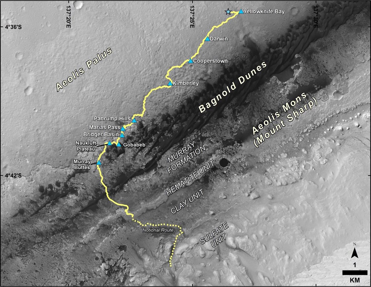
English: This map shows the route driven by NASA's Curiosity Mars rover from the location where it landed in August 2012 to its location in December 2016, which is in the upper half of a geological unit called the Murray formation, on lower Mount Sharp.
Blue triangles mark waypoints investigated by Curiosity during the rover's two-year prime mission and first two-year extended mission. The "Hematite Unit" and "Clay Unit" are key destinations for the second two-year extension, through September 2018. An approximate possible route is indicated for studying those layers of the mountain. The base image for the map is from the High Resolution Imaging Science Experiment (HiRISE) camera on NASA's Mars Reconnaissance Orbiter. North is up. Bagnold Dunes form a band of dark, wind-blown material at the foot of Mount Sharp. The scale bar at lower right represents one kilometer (0.62 mile). For broader-context images of the area, see PIA17355, PIA16064 and PIA16058. Presented at the 2016 AGU Fall Meeting on Dec. 13. in San Francisco, CA. NASA's Jet Propulsion Laboratory, a division of Caltech in Pasadena, California, manages the Mars Science Laboratory Project and Mars Reconnaissance Orbiter Project for NASA's Science Mission Directorate, Washington. For more information about Curiosity, visit http://www.nasa.gov/msl and http://mars.jpl.nasa.gov/msl. |
| תאריך יצירה | 13 December 2016 (published 13 December 2016) |
| מקור | Catalog page · Full-res (JPEG · TIFF) |
| יוצר | NASA/JPL-Caltech/Univ. of Arizona |
This image or video was catalogued by Jet Propulsion Laboratory of the United States National Aeronautics and Space Administration (NASA) under Photo ID: PIA21144. This tag does not indicate the copyright status of the attached work. A normal copyright tag is still required. See Commons:Licensing. Other languages:
|
| This media is a product of the Mars Science Laboratory mission Credit and attribution belongs to the mission team, if not already specified in the "author" row |
רישיון
| קובץ זה נמצא ברשות הציבור מכיוון שהוא נוצר על ידי נאס"א. מדיניות זכויות היוצרים של נאס"א קובעת ש"חומרים של NASA אינם מוגנים בזכויות יוצרים אלא אם צוין אחרת". (דף מדיניות זכויות היוצרים ב-NASA או מדיניות שימוש בתמונות ב-JPL). | ||
 |
אזהרות:
|
היסטוריית הקובץ
ניתן ללחוץ על תאריך/שעה כדי לראות את הקובץ כפי שנראה באותו זמן.
| תאריך/שעה | תמונה ממוזערת | ממדים | משתמש | הערה | |
|---|---|---|---|---|---|
| נוכחית | 21:57, 24 בפברואר 2017 | | 1,125 × 1,456 (281 ק"ב) | PhilipTerryGraham | User created page with UploadWizard |
שימוש בקובץ
הדף הבא משתמש בקובץ הזה: