
קובץ:Palestine-WW1-3.jpg
גודל התצוגה המקדימה הזאת: 416 × 600 פיקסלים. רזולוציות אחרות: 166 × 240 פיקסלים | 588 × 848 פיקסלים.
לקובץ המקורי (588 × 848 פיקסלים, גודל הקובץ: 104 ק"ב, סוג MIME: image/jpeg)
| זהו קובץ שמקורו במיזם ויקישיתוף. תיאורו בדף תיאור הקובץ המקורי (בעברית) מוצג למטה. |
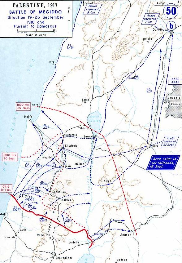
| תיאור | Map showing Allenby's final attack at Megiddo, September 1918. |
| תאריך יצירה | |
| מקור |
This map was created by the Department of Military Art and Engineering, at the U.S. Military Academy (West Point). The initial version was created under the supervision of General Vincent Esposito in 1959. It is now available on the West Point web site at: http://www.dean.usma.edu/history/web03/atlases/great%20war/great%20war%20%20pages/great%20war%20map%2050.htm The map image has been cropped to remove unneeded territory. Originally uploaded to en Wikipedia as en:Image:Palestine-WW1-3.jpg by en:User:Cglassey 25 April 2006. |
| יוצר | Department of Military Art and Engineering, at the U.S. Military Academy (West Point). |
| אישורים והיתרים (שימוש חוזר בקובץ זה) |
US Government agency (military) - no copyright |
| גרסאות אחרות | en:Image:Palestine-WW1-3.jpg |
This work is in the public domain in the United States because it is a work prepared by an officer or employee of the United States Government as part of that person’s official duties under the terms of Title 17, Chapter 1, Section 105 of the US Code.
Note: This only applies to original works of the Federal Government and not to the work of any individual U.S. state, territory, commonwealth, county, municipality, or any other subdivision. This template also does not apply to postage stamp designs published by the United States Postal Service since 1978. (See § 313.6(C)(1) of Compendium of U.S. Copyright Office Practices). It also does not apply to certain US coins; see The US Mint Terms of Use.
|
 | |
| הקובץ הזה זוהה כקובץ חופשי מכל מגבלה ידועה תחת חוק זכויות היוצרים, כולל כל הזכויות הקשורות והסמוכות. | ||

|
יש ליצור מחדש את התמונה battle map הזו באמצעות גרפיקה וקטורית כדוגמת קובץ SVG. לפעולה זו מספר יתרונות, כפי שניתן לקרוא (באנגלית) בדף Commons:Media for cleanup. אם ברשותכם קובץ SVG, אנא העלו אותו. לאחר מכן, החליפו תבנית זו בתבנית
{{vector version available|שם הקובץ.svg}} |


היסטוריית הקובץ
ניתן ללחוץ על תאריך/שעה כדי לראות את הקובץ כפי שנראה באותו זמן.
| תאריך/שעה | תמונה ממוזערת | ממדים | משתמש | הערה | |
|---|---|---|---|---|---|
| נוכחית | 10:00, 20 בפברואר 2008 | | 848 × 588 (104 ק"ב) | Rcbutcher | {{Information |Description=Map showing Allenby's final attack at Megiddo, September 1918. |Source=This map was created by the Department of Military Art and Engineering, at the U.S. Military Academy (West Point). The initial version was created under the |
שימוש בקובץ
הדף הבא משתמש בקובץ הזה:
שימוש גלובלי בקובץ
אתרי הוויקי השונים הבאים משתמשים בקובץ זה:
- שימוש באתר azb.wikipedia.org
- שימוש באתר az.wikipedia.org
- שימוש באתר bn.wikipedia.org
- שימוש באתר ca.wikipedia.org
- שימוש באתר cs.wikipedia.org
- שימוש באתר da.wikipedia.org
- שימוש באתר en.wikipedia.org
- שימוש באתר fa.wikipedia.org
- שימוש באתר fr.wikipedia.org
- שימוש באתר hu.wikipedia.org
- שימוש באתר it.wikipedia.org
- שימוש באתר ja.wikipedia.org
- שימוש באתר ko.wikipedia.org
- שימוש באתר lv.wikipedia.org
- שימוש באתר pl.wikipedia.org
- שימוש באתר pnb.wikipedia.org
- שימוש באתר pt.wikipedia.org
- שימוש באתר ro.wikipedia.org
- שימוש באתר ru.wikipedia.org
- שימוש באתר sh.wikipedia.org
- שימוש באתר sl.wikipedia.org
- שימוש באתר sr.wikipedia.org
- שימוש באתר tr.wikipedia.org
- שימוש באתר ur.wikipedia.org
- שימוש באתר zh.wikipedia.org