
קובץ:Ph locator map palawan.png
אין גרסה ברזולוציה גבוהה יותר.
Ph_locator_map_palawan.png (300 × 440 פיקסלים, גודל הקובץ: 26 ק"ב, סוג MIME: image/png)
| זהו קובץ שמקורו במיזם ויקישיתוף. תיאורו בדף תיאור הקובץ המקורי (בעברית) מוצג למטה. |
תקציר
| תיאור |
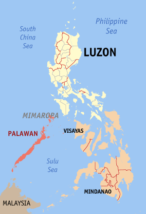
English: Map of the Philippines showing the location of Palawan. Red shade: Palawan Province; Light shade: Luzon Island Group; Orange: Rest of the Philippines |
| תאריך יצירה | |
| מקור | English Wikipedia |
| יוצר | Eugene Alvin Villar (seav) |
רישיון

|
מוענקת בכך הרשות להעתיק, להפיץ או לשנות את המסמך הזה, לפי תנאי הרישיון לשימוש חופשי במסמכים של גנו, גרסה 1.2 או כל גרסה מאוחרת יותר שתפורסם על־ידי המוסד לתוכנה חופשית; ללא פרקים קבועים, ללא טקסט עטיפה קדמית וללא טקסט עטיפה אחורית. עותק של הרישיון כלול בפרק שכותרתו הרישיון לשימוש חופשי במסמכים של גנו. |
| הקובץ הזה מתפרסם לפי תנאי רישיון קריאייטיב קומונז ייחוס-שיתוף זהה 3.0 לא מותאם. | ||
| ||
| תבנית רישוי זו הוספה לקובץ כחלק מעדכון רישיון GFDL. |

|
If you choose to use this work under the Creative Commons license stated on this page, the author, Eugene Alvin Villar (seav), would like you to attribute the work to him (among other requirements such as indicating that the work is licensed under the Creative Commons) with the following text or similar:
© Eugene Alvin Villar, 2003
His name should be a link to his Wikimedia Commons userpage. If a link is not possible, then the url should be placed in parentheses after the name. If the work has been substantially altered by other people (see the File history section below), then this particular attribution requirement is waived, which means you can attribute the work in any reasonable manner. This attribution requirement is provided pursuant to the Creative Commons Attribution mechanism where "you must attribute the work in the manner specified by the author or licensor (but not in any way that suggests that they endorse you or your use of the work)." (See "Attribution" in the Creative Commons website.)
|
היסטוריית הקובץ
ניתן ללחוץ על תאריך/שעה כדי לראות את הקובץ כפי שנראה באותו זמן.
| תאריך/שעה | תמונה ממוזערת | ממדים | משתמש | הערה | |
|---|---|---|---|---|---|
| נוכחית | 16:28, 1 ביולי 2009 | | 440 × 300 (26 ק"ב) | Hariboneagle927 | Palawan is in the MIMAROPA region references: http://en.wikipedia.org/wiki/MIMAROPA |
| 16:53, 30 בדצמבר 2005 |  | 440 × 300 (19 ק"ב) | Magalhães | Map of the Philippines showing the location of Palawan. Created and copyright (2003) by seav. Released under the GNU FDL. | |
| 23:45, 18 באוגוסט 2005 |  | 450 × 300 (15 ק"ב) | Gildemax | Map of the Philippines showing the location of Palawan. Map of the Philippines showing the location of Palawan. Created and copyright (2003) by [[:en:user:]seav]]Released under the GNU FDL. Source: http://en.wikipedia.org/wiki/Image:Ph_locator_map_pal |
שימוש בקובץ
![]() אין בוויקיפדיה דפים המשתמשים בקובץ זה.
אין בוויקיפדיה דפים המשתמשים בקובץ זה.
שימוש גלובלי בקובץ
אתרי הוויקי השונים הבאים משתמשים בקובץ זה:
- שימוש באתר nl.wikipedia.org