
קובץ:Pinatubo evacuation areas.gif

גודל התצוגה המקדימה הזאת: 800 × 575 פיקסלים. רזולוציות אחרות: 320 × 230 פיקסלים | 640 × 460 פיקסלים | 1,000 × 719 פיקסלים.
לקובץ המקורי (1,000 × 719 פיקסלים, גודל הקובץ: 95 ק"ב, סוג MIME: image/gif)
| זהו קובץ שמקורו במיזם ויקישיתוף. תיאורו בדף תיאור הקובץ המקורי (בעברית) מוצג למטה. |
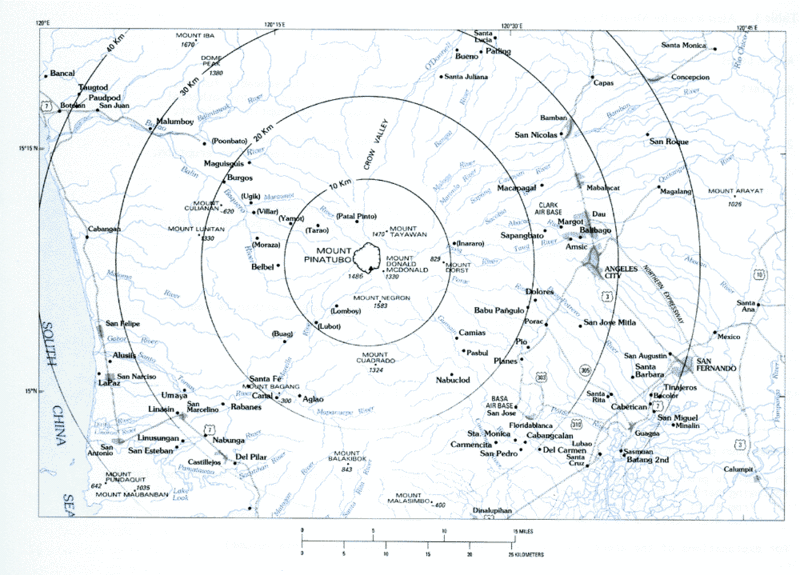
Volcanic hazard areas surrounding Mount Pinatubo.
This image is in the public domain in the United States because it only contains materials that originally came from the United States Geological Survey, an agency of the United States Department of the Interior. For more information, see the official USGS copyright policy.
|
היסטוריית הקובץ
ניתן ללחוץ על תאריך/שעה כדי לראות את הקובץ כפי שנראה באותו זמן.
| תאריך/שעה | תמונה ממוזערת | ממדים | משתמש | הערה | |
|---|---|---|---|---|---|
| נוכחית | 12:59, 8 במרץ 2006 | | 719 × 1,000 (95 ק"ב) | Magalhães | Volcanic hazard areas surrounding Mount Pinatubo. {{PD-USGov-Interior-USGS}} Category:Mount Pinatubo |
שימוש בקובץ
הדף הבא משתמש בקובץ הזה:
שימוש גלובלי בקובץ
אתרי הוויקי השונים הבאים משתמשים בקובץ זה:
- שימוש באתר bg.wikipedia.org
- שימוש באתר cs.wikipedia.org
- שימוש באתר el.wikipedia.org
- שימוש באתר en.wikipedia.org
- שימוש באתר es.wikipedia.org
- שימוש באתר fr.wikipedia.org
- שימוש באתר nl.wikipedia.org
- שימוש באתר pam.wikipedia.org