
קובץ:Pind-Meglen.png
אין גרסה ברזולוציה גבוהה יותר.
Pind-Meglen.png (200 × 204 פיקסלים, גודל הקובץ: 23 ק"ב, סוג MIME: image/png)
| זהו קובץ שמקורו במיזם ויקישיתוף. תיאורו בדף תיאור הקובץ המקורי (בעברית) מוצג למטה. |
תקציר
| תיאור |
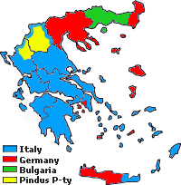
Approximative area (yellow) proposed by Alcibiades Diamandi for an eventual puppet-state called "Principality of the Pindus" in northern Greece under Italian occupation (this name was initially used in 1917 for another similar italian project). Diamandi's attempt of statehood had neither definite territory nor any borders, and never came close to realization; the yellow area in this map is likely to cover the maximalist area of the "Principality". |
| מקור | נוצר על־ידי מעלה היצירה, since a hand-drawn boundary (1942 or 1943) surimposed on a map of the Aromanians areas in Balkans, found & seen in the library of the Military Museum of Bucharest. |
| יוצר | Spiridon MANOLIU |
רישיון
| קובץ זה זמין לפי תנאי הקדשה עולמית לנחלת הכלל CC0 1.0 של Creative Commons. | |
| האדם ששייך יצירה להיתר הזה הקדיש את היצירה לנחלת הכלל על־ידי ויתור על כל הזכויות שלו או שלה על היצירה בכל העולם לפי חוק זכויות יוצרים, לרבות כל הזכויות הקשורות או הסמוכות כקבוע בחוק. באפשרותך להעתיק, לשנות, להפיץ, או להציג את היצירה, אפילו למטרות מסחריות, וכל זה אפילו מבלי לבקש רשות.
|
היסטוריית הקובץ
ניתן ללחוץ על תאריך/שעה כדי לראות את הקובץ כפי שנראה באותו זמן.
| תאריך/שעה | תמונה ממוזערת | ממדים | משתמש | הערה | |
|---|---|---|---|---|---|
| נוכחית | 20:39, 3 במאי 2010 | | 204 × 200 (23 ק"ב) | Spiridon Ion Cepleanu | {{Information |Description={{ro|1=Principatul de Pind si Meglen, 1941-1943}} |Source={{own}} |Author=Spiridon MANOLIU |Date= |Permission= |other_versions= }} Category:Maps of Greece |
שימוש בקובץ
![]() אין בוויקיפדיה דפים המשתמשים בקובץ זה.
אין בוויקיפדיה דפים המשתמשים בקובץ זה.
שימוש גלובלי בקובץ
אתרי הוויקי השונים הבאים משתמשים בקובץ זה:
- שימוש באתר cs.wikipedia.org
- שימוש באתר en.wikipedia.org
- שימוש באתר fa.wikipedia.org
- שימוש באתר it.wikipedia.org
- שימוש באתר ka.wikipedia.org
- שימוש באתר lv.wikipedia.org
- שימוש באתר sq.wikipedia.org
- שימוש באתר zh.wikipedia.org