
קובץ:Portugalliae 1561 (Baseado no primeiro mapa de Portugal)-JM.jpg

לקובץ המקורי (6,048 × 4,120 פיקסלים, גודל הקובץ: 8.4 מ"ב, סוג MIME: image/jpeg)
| זהו קובץ שמקורו במיזם ויקישיתוף. תיאורו בדף תיאור הקובץ המקורי (בעברית) מוצג למטה. |
תקציר
- From portuguese wikipedia José Manuel CH--GE 14:34, 9 Novembro 2005 (UTC)
| תיאור |
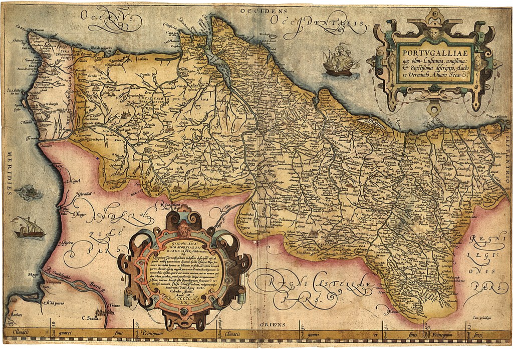
English: Portugalliae que olim Lusitania, novissima & exactissima descriptio. [1] Adaptation in the "Theatrum Orbis Terrarum" (1570) de Abraham Ortelius from the alleged first map of Portugal (1560) by Álvaro Seco. Português: Portugalliae que olim Lusitania, novissima & exactissima descriptio. [2] é provavelmente o primeiro mapa de Portugal. Feito por Álvaro Seco é provavelmente publicado em Roma por volta de 1560 com o título "Tabula Geografica Portugalliae". |
| תאריך יצירה | |
| מקור | נוצר על־ידי מעלה היצירה |
| יוצר | Jose Manuel |
| גרסאות אחרות |
|
-JM_(pormenor_com_Troia).jpg)
_-_Geographicus_-_Portugalliae-ortelius-1587.jpg)


-JM.jpg)
-JM.jpg?uselang=he)
רישיון
|
יצירה זו נמצאת בנחלת הכלל במדינת המקור ובמדינות אחרות בהם תקופת זכויות היוצרים היא משך חיי היוצר ו-70 שנה (או פחות) מפטירתו.
| |
| הקובץ הזה זוהה כקובץ חופשי מכל מגבלה ידועה תחת חוק זכויות היוצרים, כולל כל הזכויות הקשורות והסמוכות. | |
היסטוריית הקובץ
ניתן ללחוץ על תאריך/שעה כדי לראות את הקובץ כפי שנראה באותו זמן.
| תאריך/שעה | תמונה ממוזערת | ממדים | משתמש | הערה | |
|---|---|---|---|---|---|
| נוכחית | 09:01, 13 בדצמבר 2018 | | 4,120 × 6,048 (8.4 מ"ב) | SteinsplitterBot | Bot: Image rotated by 90° |
| 03:34, 11 באוגוסט 2012 |  | 6,054 × 4,120 (8.42 מ"ב) | Jose Manuel | Best vertical photo resolution and sharp | |
| 02:04, 11 באוגוסט 2012 |  | 4,120 × 6,054 (21.47 מ"ב) | Jose Manuel | Best photo resolution and sharp | |
| 18:26, 9 בנובמבר 2005 |  | 600 × 403 (94 ק"ב) | Nuno Tavares | ;'''Description:''' :{{português}}: '' Portugalliae 1561 (Baseado no primeiro mapa de Portugal) " ;'''Source/Credits:''' : {{português}}: Fotografias Imagens ilustrações do usuário registrado. (''Não protegidos por copyright''). <br> :: Igualmente p |
שימוש בקובץ
![]() אין בוויקיפדיה דפים המשתמשים בקובץ זה.
אין בוויקיפדיה דפים המשתמשים בקובץ זה.
שימוש גלובלי בקובץ
אתרי הוויקי השונים הבאים משתמשים בקובץ זה:
- שימוש באתר an.wikipedia.org
- שימוש באתר azb.wikipedia.org
- שימוש באתר be.wikipedia.org
- שימוש באתר ca.wikipedia.org
- שימוש באתר cs.wikipedia.org
- שימוש באתר de.wikipedia.org
- שימוש באתר en.wikipedia.org
- שימוש באתר eo.wikipedia.org
- שימוש באתר es.wikipedia.org
- שימוש באתר eu.wikipedia.org
- שימוש באתר fr.wikipedia.org
- שימוש באתר ga.wikipedia.org
- שימוש באתר gl.wikipedia.org
- שימוש באתר id.wikipedia.org
- שימוש באתר it.wikipedia.org
- שימוש באתר ml.wikipedia.org
- שימוש באתר ms.wikipedia.org
- שימוש באתר nl.wikipedia.org
- שימוש באתר nn.wikipedia.org
- שימוש באתר oc.wikipedia.org
- שימוש באתר pl.wikipedia.org
- שימוש באתר pt.wikipedia.org
- שימוש באתר ru.wikipedia.org
- שימוש באתר sk.wikipedia.org
- שימוש באתר sv.wikipedia.org
- שימוש באתר uk.wikipedia.org
- שימוש באתר vi.wikipedia.org
- שימוש באתר www.wikidata.org
- שימוש באתר zh.wikipedia.org
-JM.jpg)