
קובץ:Provinces of Cambodia loss to Thailand during Franco-Thai War.png

לקובץ המקורי (1,200 × 900 פיקסלים, גודל הקובץ: 187 ק"ב, סוג MIME: image/png)
| זהו קובץ שמקורו במיזם ויקישיתוף. תיאורו בדף תיאור הקובץ המקורי (בעברית) מוצג למטה. |
This file may not have the correct information on its copyright status.
The reason given by the user who added this tag is: File has incomplete source information; it's obviously based on other CC-licensed maps here on Commons.
Notify the uploader with:
Items tagged with this template are sorted into Category:Items with disputed copyright information.
|
תקציר
| תיאור |
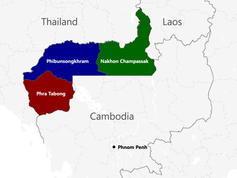
English: The territories of Cambodia and Laos annexed by Thailand in 1941, according to "ประกาศ ใช้อนุสัญญาสันติภาพและบรรดาภาคผนวก ระหว่างไทยและฝรั่งเศส", regrouped as in the map. |
| תאריך יצירה | |
| מקור | נוצר על־ידי מעלה היצירה |
| יוצר | Murashel, edited by: Thanyakij |
רישיון
- הנכם רשאים:
- לשתף – להעתיק, להפיץ ולהעביר את העבודה
- לערבב בין עבודות – להתאים את העבודה
- תחת התנאים הבאים:
- ייחוס – יש לתת ייחוס הולם, לתת קישור לרישיון, ולציין אם נעשו שינויים. אפשר לעשות את זה בכל צורה סבירה, אבל לא בשום צורה שמשתמע ממנה שמעניק הרישיון תומך בך או בשימוש שלך.
- שיתוף זהה – אם תיצרו רמיקס, תשנו, או תבנו על החומר, חובה עליכם להפיץ את התרומות שלך לפי תנאי רישיון זהה או תואם למקור.
היסטוריית הקובץ
ניתן ללחוץ על תאריך/שעה כדי לראות את הקובץ כפי שנראה באותו זמן.
| תאריך/שעה | תמונה ממוזערת | ממדים | משתמש | הערה | |
|---|---|---|---|---|---|
| נוכחית | 07:48, 23 ביולי 2017 | | 900 × 1,200 (187 ק"ב) | Aquapatinth | change - southern border of Phibulsongkhram and Nakhon Champassak Provinces to the 13.5th parallel and - southeastern border of Phibulsongkhram to meridian line from the point which border line between Siem Reap and Battanbang Province met Tonle Sap.... |
| 10:19, 16 בפברואר 2016 |  | 921 × 1,001 (303 ק"ב) | Xufanc | corrected spelling | |
| 08:49, 12 בפברואר 2016 |  | 921 × 1,001 (303 ק"ב) | Xufanc | Added missing part of Nakhon Champassak Province | |
| 20:46, 25 בספטמבר 2014 |  | 903 × 1,000 (308 ק"ב) | RJFF | Somehow the revert did not work. | |
| 20:38, 25 בספטמבר 2014 |  | 903 × 1,000 (308 ק"ב) | RJFF | Reverted to version as of 17:36, 25 September 2014 | |
| 20:37, 25 בספטמבר 2014 |  | 903 × 1,000 (308 ק"ב) | RJFF | Reverted to version as of 18:43, 30 December 2013 | |
| 20:36, 25 בספטמבר 2014 |  | 903 × 1,000 (308 ק"ב) | RJFF | Reverted to version as of 18:43, 30 December 2013: The other version seems to be more accurate, see [http://daravireak.files.wordpress.com/2012/10/map_thailand_3province_indochine.png here], [http://www.websitesrcg.com/border/maps/indochina-1942.jpg he... | |
| 18:32, 9 בפברואר 2014 |  | 903 × 1,000 (321 ק"ב) | Murashel | In Peace treaty in Tokyo Thais gain territory of Koh Kong. | |
| 21:43, 30 בדצמבר 2013 |  | 903 × 1,000 (308 ק"ב) | Derkommander0916 | Thailand never took Koh Kong and Pursat Refer this: http://www.geographicus.com/P/AntiqueMap/Thailand-japanese-1943 | |
| 18:01, 9 ביוני 2013 |  | 903 × 1,000 (321 ק"ב) | Murashel | User created page with UploadWizard |
שימוש בקובץ
הדף הבא משתמש בקובץ הזה:
שימוש גלובלי בקובץ
אתרי הוויקי השונים הבאים משתמשים בקובץ זה:
- שימוש באתר ca.wikipedia.org
- שימוש באתר en.wikipedia.org
- שימוש באתר es.wikipedia.org
- שימוש באתר fa.wikipedia.org
- שימוש באתר fr.wikipedia.org
- שימוש באתר it.wikipedia.org
- שימוש באתר ja.wikipedia.org
- שימוש באתר km.wikipedia.org
- שימוש באתר lo.wikipedia.org
- שימוש באתר nl.wikipedia.org
- שימוש באתר pl.wikipedia.org
- שימוש באתר ru.wikipedia.org
- שימוש באתר th.wikipedia.org
- שימוש באתר vi.wikipedia.org
- שימוש באתר zh.wikipedia.org