
קובץ:Radar-bright-band.png
אין גרסה ברזולוציה גבוהה יותר.
Radar-bright-band.png (791 × 449 פיקסלים, גודל הקובץ: 263 ק"ב, סוג MIME: image/png)
| זהו קובץ שמקורו במיזם ויקישיתוף. תיאורו בדף תיאור הקובץ המקורי (בעברית) מוצג למטה. |
תקציר
| תיאור |
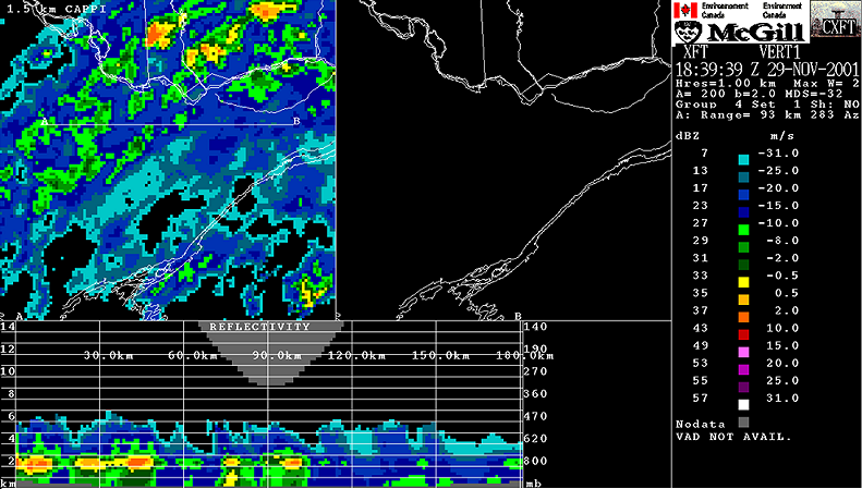
Français : En haut, CAPPI de 1,5km d'altitude montrent de forts échos radar, en jaune, parmi des échos plus faibles en vert. Dans la partie du bas, la coupe verticale à travers les données radar montre que ces intensités sont dues à la présence d'une zone de réflectivité plus intense se situant entre 1,5 km à 2,5 km d'altitude. Cette bande brillante est causée par de la neige fondante.
English: Snow falling through the freezing level will melt and reach the ground as rain. On this image, at the top we can see a CAPPI of precipitations. At the bottom, there is a cross-section of the radar data from ground to 15 km. One can see a level where echos are stronger: the bright-band. The melting begin to occur just above this band and continue until its lower part. This effect is due to the fact that the reflectivity depend on the 6th power of the diameter of targets multiplied by its ability to reflect. Snow flakes are much larger than rain drops but they reflect much less so echos from snow and rain have intensities relatively close. However, when snow melt, it keeps its diameter for a while and get coated with water. The radar beam sees something similar to a very larger water dropplet and the return is producing this very strong band. |
| תאריך יצירה | 1839 UTC |
| מקור |
English: Meteorological Service of Canada (Environment Canada). Redistribution allowed if source mentionned |
| יוצר |
Français : Ce radar est opéré par Environnement Canada. La sortie radar est produite par le logiciel développé par l'Observatoire radar J.S. Marshall de l'Université McGill en collaboration avec EC. |
רישיון

|
בעלי זכויות היוצרים על הקובץ הזה מאשרים לכולם להשתמש בו לכל מטרה, בתנאי שניתן לבעלי הזכויות ייחוס נאות. הפצה, יצירות נגזרות, שימושים מסחריים וכל שימוש אחר מותרים. |
|
|
היסטוריית הקובץ
ניתן ללחוץ על תאריך/שעה כדי לראות את הקובץ כפי שנראה באותו זמן.
| תאריך/שעה | תמונה ממוזערת | ממדים | משתמש | הערה | |
|---|---|---|---|---|---|
| נוכחית | 18:20, 8 במאי 2006 | | 449 × 791 (263 ק"ב) | Pierre cb | Snow falling through the freezing level will melt and reach the ground as rain. On this image, at the top we can see a CAPPI of precipitations. At the bottom, there is a cross-section of the radar data from ground to 15 km. On can see a level where echos |
שימוש בקובץ
הדף הבא משתמש בקובץ הזה:
שימוש גלובלי בקובץ
אתרי הוויקי השונים הבאים משתמשים בקובץ זה:
- שימוש באתר en.wikipedia.org
- שימוש באתר es.wikipedia.org
- שימוש באתר fr.wikipedia.org
- שימוש באתר ja.wikipedia.org